You are here: Home > Network List > XH96 - Bolivian Experiment Stations List
> Station SONI Soniquera > Earthquake Result Viewer
SONI Soniquera - Earthquake Result Viewer
| Earthquake location: |
Near Coast Of Venezuela |
| Earthquake latitude/longitude: |
10.6/-63.5 |
| Earthquake time(UTC): |
1997/07/09 (190) 19:24:13 GMT |
| Earthquake Depth: |
20 km |
| Earthquake Magnitude: |
6.2 MB, 6.8 MS, 7.0 UNKNOWN, 6.6 ME |
| Earthquake Catalog/Contributor: |
WHDF/NEIC |
|
| Network: |
XH Bolivian Experiment |
| Station: |
SONI Soniquera |
| Lat/Lon: |
21.95 S/67.35 W |
| Elevation: |
4165 m |
|
| Distance: |
32.6 deg |
| Az: |
186.674 deg |
| Baz: |
7.07 deg |
| Ray Param: |
0.07857717 |
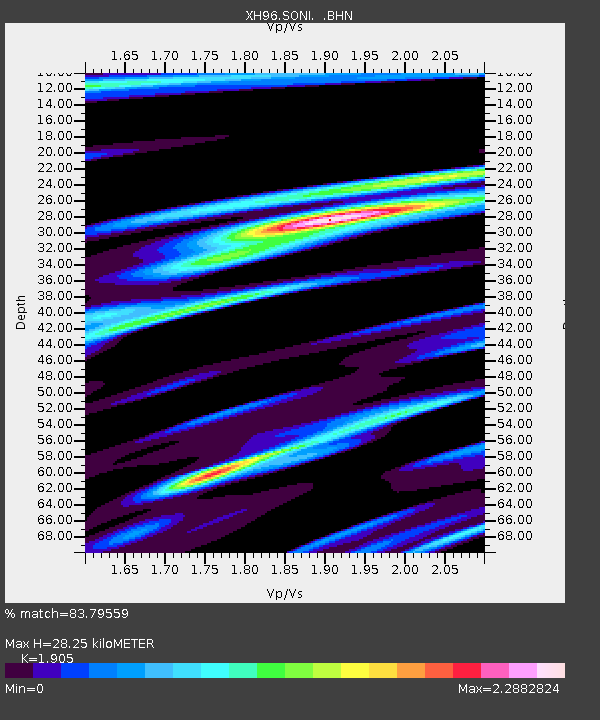
| Estimated Moho Depth: |
28.25 km |
| Estimated Crust Vp/Vs: |
1.90 |
| Assumed Crust Vp: |
6.319 km/s |
| Estimated Crust Vs: |
3.317 km/s |
| Estimated Crust Poisson's Ratio: |
0.31 |
|
| Radial Match: |
83.79559 % |
| Radial Bump: |
400 |
| Transverse Match: |
71.56707 % |
| Transverse Bump: |
400 |
| SOD ConfigId: |
6273 |
| Insert Time: |
2010-03-09 08:24:24.844 +0000 |
| GWidth: |
2.5 |
| Max Bumps: |
400 |
| Tol: |
0.001 |
|

Signal To Noise
| Channel | StoN | STA | LTA |
| XH:SONI: :BHN:19970709T19:30:12.308008Z | 1.1979096 | 5.93448E-5 | 4.9540296E-5 |
| XH:SONI: :BHE:19970709T19:30:12.308008Z | 1.4696242 | 3.8183607E-5 | 2.5981886E-5 |
| XH:SONI: :BHZ:19970709T19:30:12.308008Z | 2.3812623 | 7.332029E-5 | 3.0790514E-5 |
| Arrivals |
| Ps | 4.3 SECOND |
| PpPs | 12 SECOND |
| PsPs/PpSs | 16 SECOND |


