
Station XH SONI - Soniquera
Network: XH96 - Bolivian Experiment
Nearby stations (2 deg radius)
| Station | Name | (Lat, Lon) | Start / End | Elevation |
| SONI | Soniquera | (-21.95, -67.35) | 1996-11-10 / 1997-12-31 | 4165 m |
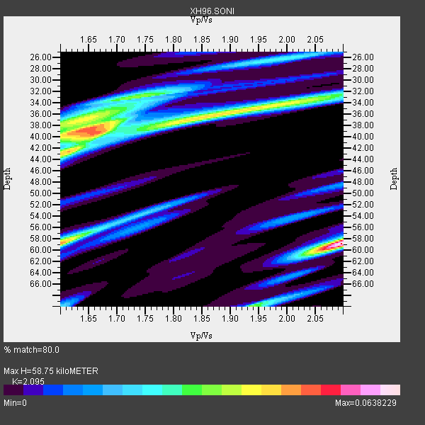
| Crust2 Type: | RC,orogen/65km Tibet, 4.5 km seds. |
| Thickness Estimate: | 59 km |
| Thickness StdDev: | 11 km |
| Vp/Vs Estimate: | 2.10 |
| Vp/Vs StdDev: | 0.20 |
| Vs Estimate: | 3.016 km/s |
| Poisson's Ratio: | 0.35 |
| Peak Value: | 0.06 |
| Assumed Vp: | 6.319 km/s |
| Ps Weight: | 0.33333334 |
| PpPs Weight: | 0.33333334 |
| PsPs Weight: | 0.33333328 |
| Residual Complexity: | 0.938 |
| Nearby stations H: | +- |
| (2.0 deg) Vp/Vs: | +- |
2 with match > 90% ( 20.0 %) and 4 with match > 80% ( 40.0 %) out of 10.
Download stack as xyz text file.
Azimuth Distribution of Events:

Prior Results for this Station
| Study | Thickness | Vp/Vs | Vp | Vs | Poissons Ratio | Extra |
| EARS | 59 km | 2.10 | 6.319 km/s | 3.016 km/s | 0.35 | |
| Crust2.0 | 65 km | 1.76 | 6.319 km/s | 3.593 km/s | 0.26 | RC,orogen/65km Tibet, 4.5 km seds. |
| Global Maxima | 59 km | 2.10 | 6.319 km/s | 3.016 km/s | 0.35 | amp=0.0638229 |
| Local Maxima 1 | 39 km | 1.64 | 6.319 km/s | 3.847 km/s | 0.21 | amp=0.049456604 |
| Local Maxima 2 | 59 km | 1.60 | 6.319 km/s | 3.95 km/s | 0.18 | amp=0.047737107 |
| Local Maxima 3 | 42 km | 1.62 | 6.319 km/s | 3.913 km/s | 0.19 | amp=0.035667177 |
| Local Maxima 4 | 37 km | 1.82 | 6.319 km/s | 3.482 km/s | 0.28 | amp=0.033353455 |
| Predicted Arrivals for vertical incidence (zero ray parameter) | |
| Ps | 10.18 SECOND |
| PpPs | 28.77 SECOND |
| PsPs/PpSs | 38.95 SECOND |
Events Processed for this Station
Download zip of receiver functions as SAC
Plot maxima for each earthquake.
Events Used in the Stack
(4 events)| Radial Match | Distance | Baz | FERegion | Time | Lat/Lon | Depth | Magnitude |
| 96.339325 | 48.6 deg | 318.955 deg | Near Coast Of Guerrero, Mexico | 1997/07/19 14:22:08 GMT | (16.3, -98.2) | 33 km | 5.7 MB, 6.3 MS, 6.8 UNKNOWN, 6.0 ME |
| 93.53678 | 52.5 deg | 317.721 deg | Guerrero, Mexico | 1997/05/22 07:50:53 GMT | (18.7, -101.6) | 70 km | 5.9 MB, 6.0 MS, 6.6 UNKNOWN, 6.5 MW |
| 85.0663 | 52.9 deg | 316.308 deg | Michoacan, Mexico | 1997/01/11 20:28:26 GMT | (18.2, -102.8) | 33 km | 6.5 MB, 6.9 MS, 7.1 UNKNOWN, 7.0 ME |
| 83.79559 | 32.6 deg | 7.07 deg | Near Coast Of Venezuela | 1997/07/09 19:24:13 GMT | (10.6, -63.5) | 20 km | 6.2 MB, 6.8 MS, 7.0 UNKNOWN, 6.6 ME |
Losers
(6 events)| Radial Match | Distance | Baz | FERegion | Time | Lat/Lon | Depth | Magnitude | Reason |
| 88.30311 | 56.4 deg | 313.128 deg | Off Coast Of Jalisco, Mexico | 1997/05/01 11:37:36 GMT | (19.0, -107.3) | 33 km | 6.1 MB, 6.8 MS, 7.1 UNKNOWN, 7.1 ME | |
| 66.67187 | 46.8 deg | 150.631 deg | South Sandwich Islands Region | 1997/06/02 21:24:38 GMT | (-57.8, -25.5) | 33 km | 5.9 MB, 5.8 MS, 6.1 UNKNOWN, 6.1 MW | |
| 65.85211 | 33.4 deg | 11.464 deg | Windward Islands | 1997/04/22 10:11:44 GMT | (11.0, -61.0) | 5.0 km | 5.6 MB | |
| 52.087395 | 42.9 deg | 62.944 deg | Central Mid-Atlantic Ridge | 1996/12/10 08:36:18 GMT | (0.9, -30.0) | 10 km | 6.0 MB, 6.2 MS, 6.6 UNKNOWN, 6.6 MW | |
| 49.987507 | 96.9 deg | 236.104 deg | Kermadec Islands Region | 1997/04/12 09:21:56 GMT | (-28.2, -178.4) | 184 km | 5.8 MB, 6.0 UNKNOWN, 6.0 MW | |
| 45.62053 | 56.6 deg | 25.548 deg | Northern Mid-Atlantic Ridge | 1996/12/09 11:28:48 GMT | (29.9, -42.9) | 10 km | 5.9 MB, 6.1 MS, 6.0 UNKNOWN, 5.9 MW |
