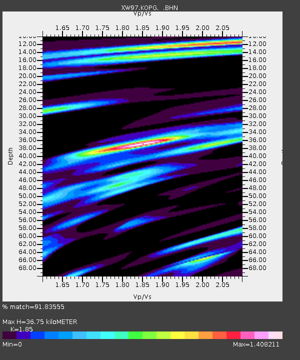
KOPG XW.KOPG - Earthquake Result Viewer
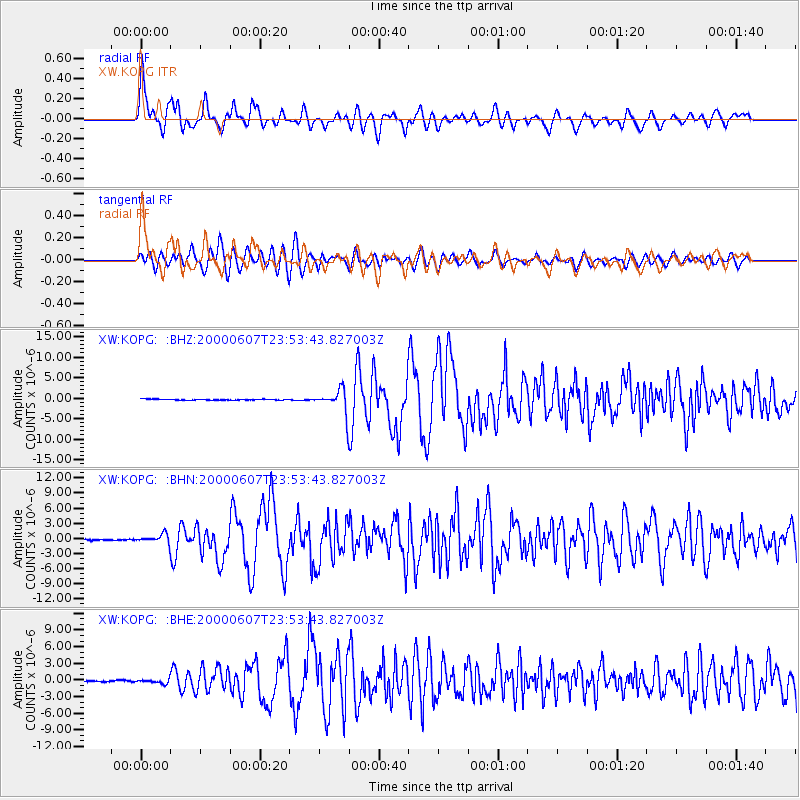
Earthquake location: Southern Sumatra, Indonesia
Earthquake latitude/longitude: -4.6/101.9
Earthquake time(UTC): 2000/06/07 (159) 23:45:26 GMT
Earthquake Depth: 33 km
Earthquake Magnitude: 6.1 MB, 6.7 MS, 6.7 MW, 6.5 MW
Earthquake Catalog/Contributor: WHDF/NEIC
Network: XW Tien Shan Continental Dynamics
Station: KOPG XW.KOPG
Lat/Lon: 40.50 N/79.04 E
Elevation: 1114 m
Distance: 49.6 deg
Az: 337.086 deg
Baz: 149.403 deg
Ray Param: 0.06856064
Estimated Moho Depth: 36.75 km
Estimated Crust Vp/Vs: 1.85
Assumed Crust Vp: 6.353 km/s
Estimated Crust Vs: 3.434 km/s
Estimated Crust Poisson's Ratio: 0.29
Radial Match: 91.83555 %
Radial Bump: 400
Transverse Match: 85.373955 %
Transverse Bump: 400
SOD ConfigId: 20082
Insert Time: 2010-02-26 15:36:25.221 +0000
GWidth: 2.5
Max Bumps: 400
Tol: 0.001

Signal To Noise

ChannelStoNSTALTA
XW:KOPG: :BHN:20000607T23:53:43.827003Z4.5911319.112434E-71.9847904E-7
XW:KOPG: :BHE:20000607T23:53:43.827003Z2.15396144.0586767E-71.8842847E-7
XW:KOPG: :BHZ:20000607T23:53:43.827003Z25.7477252.9605505E-61.14982996E-7
Arrivals
Ps5.2 SECOND
PpPs16 SECOND
PsPs/PpSs21 SECOND