
Station XW KOPG - XW.KOPG
Network: XW97 - Tien Shan Continental Dynamics
Nearby stations (2 deg radius)
| Station | Name | (Lat, Lon) | Start / End | Elevation |
| KOPG | XW.KOPG | (40.50, 79.04) | 1999-06-12 / 2002-01-01 | 1114 m |
| Crust2 Type: | PE,orogen/50km, Tibet, 0.5 km seds. |
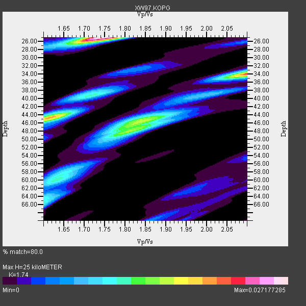
| Thickness Estimate: | 25 km |
| Thickness StdDev: | 8.9 km |
| Vp/Vs Estimate: | 1.74 |
| Vp/Vs StdDev: | 0.14 |
| Vs Estimate: | 3.651 km/s |
| Poisson's Ratio: | 0.25 |
| Peak Value: | 0.03 |
| Assumed Vp: | 6.353 km/s |
| Ps Weight: | 0.33333334 |
| PpPs Weight: | 0.33333334 |
| PsPs Weight: | 0.33333328 |
| Residual Complexity: | 0.877 |
| Nearby stations H: | +- |
| (2.0 deg) Vp/Vs: | +- |
9 with match > 90% ( 31.034483 %) and 29 with match > 80% ( 100.0 %) out of 29.
Download stack as xyz text file.
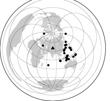
Azimuth Distribution of Events:
Prior Results for this Station
| Study | Thickness | Vp/Vs | Vp | Vs | Poissons Ratio | Extra |
| EARS | 25 km | 1.74 | 6.353 km/s | 3.651 km/s | 0.25 | |
| Crust2.0 | 50 km | 1.76 | 6.353 km/s | 3.612 km/s | 0.26 | PE,orogen/50km, Tibet, 0.5 km seds. |
| Global Maxima | 25 km | 1.74 | 6.353 km/s | 3.651 km/s | 0.25 | amp=0.027177285 |
| Local Maxima 1 | 34 km | 2.10 | 6.353 km/s | 3.029 km/s | 0.35 | amp=0.021344682 |
| Local Maxima 2 | 44 km | 1.62 | 6.353 km/s | 3.928 km/s | 0.19 | amp=0.018868681 |
| Local Maxima 3 | 46 km | 1.84 | 6.353 km/s | 3.462 km/s | 0.29 | amp=0.015209025 |
| Local Maxima 4 | 48 km | 1.80 | 6.353 km/s | 3.525 km/s | 0.28 | amp=0.011192058 |
| Predicted Arrivals for vertical incidence (zero ray parameter) | |
| Ps | 2.91 SECOND |
| PpPs | 10.78 SECOND |
| PsPs/PpSs | 13.69 SECOND |
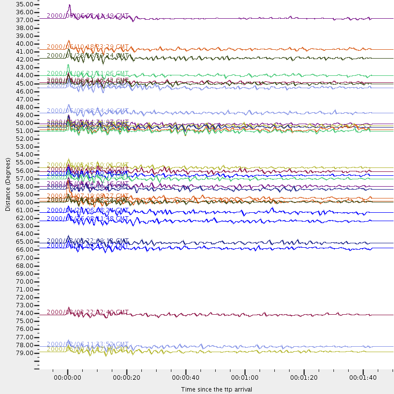
Events Processed for this Station
Download zip of receiver functions as SAC
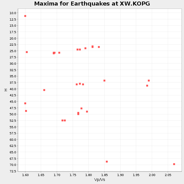
Plot maxima for each earthquake.
Events Used in the Stack
(29 events)| Radial Match | Distance | Baz | FERegion | Time | Lat/Lon | Depth | Magnitude |
| 93.441055 | 49.7 deg | 149.24 deg | Southern Sumatra, Indonesia | 2000/06/04 16:28:26 GMT | (-4.7, 102.1) | 33 km | 6.8 MB, 8.0 MS, 7.9 MW, 7.7 MW |
| 92.77632 | 57.9 deg | 124.151 deg | Sulawesi, Indonesia | 2000/05/04 04:21:16 GMT | (-1.1, 123.6) | 26 km | 6.7 MB, 7.5 MS, 7.6 MW, 7.5 ME |
| 92.45542 | 59.6 deg | 194.945 deg | Mauritius - Reunion Region | 2000/04/07 19:08:27 GMT | (-18.0, 65.5) | 10 km | 5.5 MB, 5.9 MS, 6.3 MW, 6.2 MW |
| 91.88452 | 56.9 deg | 87.804 deg | Volcano Islands, Japan Region | 2000/03/28 11:00:22 GMT | (22.3, 143.7) | 126 km | 6.8 MB, 7.6 MS, 7.6 MW, 7.6 MW |
| 91.83555 | 49.6 deg | 149.403 deg | Southern Sumatra, Indonesia | 2000/06/07 23:45:26 GMT | (-4.6, 101.9) | 33 km | 6.1 MB, 6.7 MS, 6.7 MW, 6.5 MW |
| 91.613335 | 49.4 deg | 63.433 deg | Kuril Islands | 2000/01/28 14:21:07 GMT | (43.0, 146.8) | 61 km | 6.7 MB, 6.6 MS, 6.8 MW, 6.8 ME |
| 90.839 | 34.7 deg | 285.692 deg | Turkey | 2000/06/06 02:41:49 GMT | (40.7, 33.0) | 10 km | 5.5 MB, 6.1 MS, 6.1 MW, 6.0 MW |
| 90.23447 | 60.2 deg | 126.822 deg | Banda Sea | 2000/05/14 20:08:34 GMT | (-4.3, 123.2) | 33 km | 5.9 MB, 5.9 MS, 6.3 MW, 6.2 MW |
| 90.00102 | 56.4 deg | 116.038 deg | Talaud Islands, Indonesia | 2000/06/14 17:00:48 GMT | (4.5, 127.7) | 90 km | 6.1 MB, 5.6 MS, 6.4 MW, 6.3 MW |
| 89.674255 | 40.2 deg | 96.653 deg | Northeast Of Taiwan | 2000/01/28 16:39:24 GMT | (26.1, 124.5) | 194 km | 6.1 MB, 6.0 MW, 6.0 MW |
| 89.62068 | 47.8 deg | 75.21 deg | Near East Coast Of Honshu, Japan | 2000/06/03 08:54:49 GMT | (35.6, 140.5) | 62 km | 5.6 MB, 5.6 MS, 6.1 MW, 6.1 MW |
| 89.269745 | 44.3 deg | 87.329 deg | Southeast Of Shikoku, Japan | 2000/06/15 11:10:46 GMT | (29.4, 132.1) | 10 km | 6.0 MB, 5.6 MS, 6.1 MW, 6.1 MW |
| 89.035324 | 39.0 deg | 102.154 deg | Taiwan | 2000/06/10 18:23:29 GMT | (23.8, 121.2) | 33 km | 6.2 MB, 6.2 MS, 6.4 MW, 6.3 MW |
| 88.5769 | 55.3 deg | 118.278 deg | Talaud Islands, Indonesia | 2000/04/03 15:20:01 GMT | (4.1, 125.6) | 150 km | 5.9 MB, 6.2 MW, 6.0 MW |
| 88.54683 | 43.6 deg | 75.89 deg | Sea Of Japan | 2000/06/06 21:16:42 GMT | (36.8, 135.5) | 10 km | 5.7 MB, 5.3 MS, 5.9 MW, 5.8 MW |
| 88.40303 | 43.8 deg | 87.664 deg | Southeast Of Ryukyu Islands | 2000/06/06 14:57:02 GMT | (29.4, 131.4) | 33 km | 5.8 MB, 6.0 MS, 6.4 MW, 6.4 MW |
| 88.34232 | 80.2 deg | 106.373 deg | New Britain Region, P.N.G. | 2000/02/06 11:33:52 GMT | (-5.8, 150.9) | 33 km | 6.6 MB, 6.8 MS, 6.6 MW, 6.3 ME |
| 86.93057 | 42.6 deg | 112.882 deg | Luzon, Philippines | 2000/01/06 21:31:06 GMT | (16.1, 119.5) | 33 km | 5.8 MB, 5.9 MS, 6.3 MW, 6.2 MW |
| 86.10299 | 80.8 deg | 104.695 deg | New Britain Region, P.N.G. | 2000/06/09 01:27:15 GMT | (-5.1, 152.5) | 33 km | 5.4 MB, 6.3 MS, 6.3 MW, 6.3 MW |
| 86.02249 | 65.8 deg | 124.275 deg | Banda Sea | 2000/03/03 22:09:13 GMT | (-7.3, 128.5) | 142 km | 6.4 MB, 5.8 MS, 6.3 MW, 6.3 MW |
| 85.62907 | 55.9 deg | 124.538 deg | Minahassa Peninsula, Sulawesi | 2000/04/03 08:55:00 GMT | (0.3, 122.1) | 187 km | 5.6 MB, 5.5 MW, 5.4 MW |
| 85.41154 | 50.3 deg | 148.699 deg | Southern Sumatra, Indonesia | 2000/06/06 09:58:06 GMT | (-5.1, 102.7) | 33 km | 5.8 MB, 6.1 MS, 6.2 MW, 6.1 MW |
| 84.22718 | 50.1 deg | 148.655 deg | Southern Sumatra, Indonesia | 2000/06/05 06:34:11 GMT | (-4.9, 102.7) | 33 km | 5.4 MB, 5.5 MS, 5.8 MW |
| 83.32832 | 75.7 deg | 112.045 deg | New Guinea, Papua New Guinea | 2000/03/03 22:22:40 GMT | (-6.8, 143.8) | 10 km | 6.3 MB, 6.7 MS, 6.6 MW, 6.5 MW |
| 82.05037 | 62.8 deg | 95.002 deg | Mariana Islands | 2000/02/26 08:11:48 GMT | (13.8, 144.8) | 132 km | 6.0 MB, 5.4 MS, 6.2 MW, 6.2 MW |
| 81.91054 | 61.6 deg | 131.638 deg | Flores Sea | 2000/01/23 06:08:24 GMT | (-8.0, 120.6) | 47 km | 5.7 MB, 5.2 MS, 5.8 MW, 5.7 MW |
| 80.8675 | 60.1 deg | 89.541 deg | Mariana Islands | 1999/06/23 19:37:22 GMT | (19.3, 145.6) | 103 km | 5.5 MB, 4.9 MS |
| 80.15161 | 66.5 deg | 41.731 deg | Andreanof Islands, Aleutian Is. | 2000/04/21 04:35:17 GMT | (51.4, -178.1) | 33 km | 6.0 MB, 5.7 MS, 6.2 ML, 6.0 MW |
| 80.03763 | 58.3 deg | 329.249 deg | Iceland | 2000/06/17 15:40:41 GMT | (64.0, -20.5) | 10 km | 5.7 MB, 6.6 MS, 6.8 MW, 6.5 MW |
Losers
(0 events)| Radial Match | Distance | Baz | FERegion | Time | Lat/Lon | Depth | Magnitude | Reason |
