You are here: Home > Network List > IC - New China Digital Seismograph Network Stations List
> Station HIA Hailar, Neimenggu Autonomous Region, China > Earthquake Result Viewer
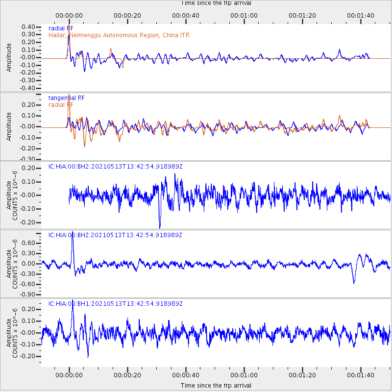
HIA Hailar, Neimenggu Autonomous Region, China - Earthquake Result Viewer
*The percent match for this event was below the threshold and hence no stack was calculated.
| Earthquake location: |
Fiji Islands Region |
| Earthquake latitude/longitude: |
-15.9/-177.4 |
| Earthquake time(UTC): |
2021/05/13 (133) 13:31:35 GMT |
| Earthquake Depth: |
424 km |
| Earthquake Magnitude: |
5.7 Mww |
| Earthquake Catalog/Contributor: |
NEIC PDE/us |
|
| Network: |
IC New China Digital Seismograph Network |
| Station: |
HIA Hailar, Neimenggu Autonomous Region, China |
| Lat/Lon: |
49.27 N/119.74 E |
| Elevation: |
620 m |
|
| Distance: |
85.3 deg |
| Az: |
324.225 deg |
| Baz: |
120.835 deg |
| Ray Param: |
$rayparam |
*The percent match for this event was below the threshold and hence was not used in the summary stack. |
|
| Radial Match: |
63.906 % |
| Radial Bump: |
400 |
| Transverse Match: |
59.663593 % |
| Transverse Bump: |
400 |
| SOD ConfigId: |
25028951 |
| Insert Time: |
2021-06-03 01:20:52.871 +0000 |
| GWidth: |
2.5 |
| Max Bumps: |
400 |
| Tol: |
0.001 |
|
Signal To Noise
| Channel | StoN | STA | LTA |
| IC:HIA:00:BHZ:20210513T13:42:54.918989Z | 4.095407 | 2.9755512E-7 | 7.265581E-8 |
| IC:HIA:00:BH1:20210513T13:42:54.918989Z | 2.7005517 | 9.532424E-8 | 3.529806E-8 |
| IC:HIA:00:BH2:20210513T13:42:54.918989Z | 2.6368454 | 9.1974684E-8 | 3.488058E-8 |
| Arrivals |
| Ps | |
| PpPs | |
| PsPs/PpSs | |


