You are here: Home > Network List > IC - New China Digital Seismograph Network Stations List
> Station HIA Hailar, Neimenggu Autonomous Region, China > Earthquake Result Viewer
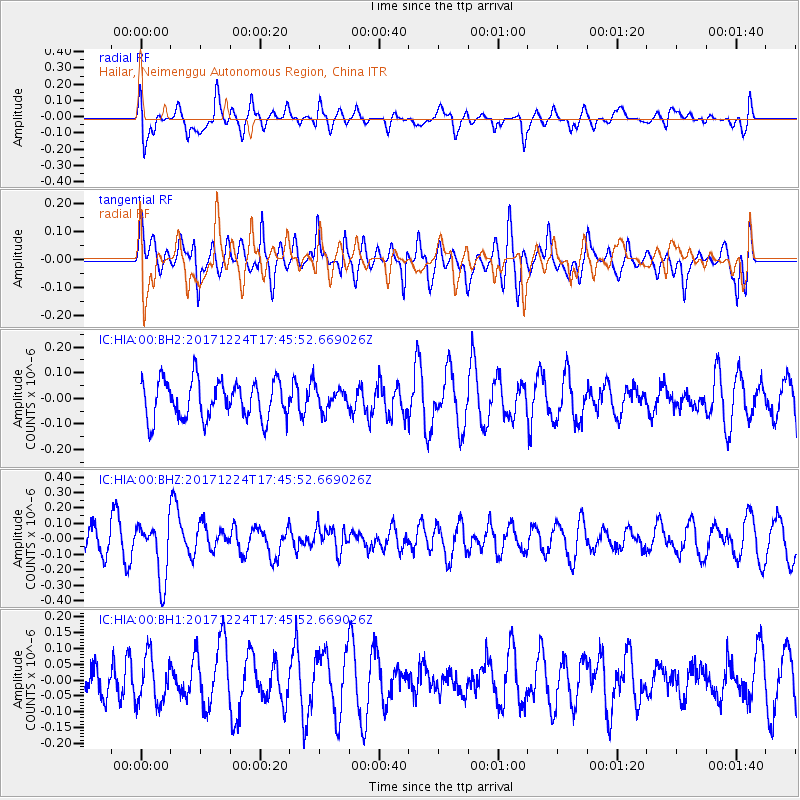
HIA Hailar, Neimenggu Autonomous Region, China - Earthquake Result Viewer
*The percent match for this event was below the threshold and hence no stack was calculated.
| Earthquake location: |
Samoa Islands Region |
| Earthquake latitude/longitude: |
-15.3/-172.9 |
| Earthquake time(UTC): |
2017/12/24 (358) 17:33:36 GMT |
| Earthquake Depth: |
10 km |
| Earthquake Magnitude: |
5.5 Mwb |
| Earthquake Catalog/Contributor: |
NEIC PDE/us |
|
| Network: |
IC New China Digital Seismograph Network |
| Station: |
HIA Hailar, Neimenggu Autonomous Region, China |
| Lat/Lon: |
49.27 N/119.74 E |
| Elevation: |
620 m |
|
| Distance: |
87.4 deg |
| Az: |
322.773 deg |
| Baz: |
116.988 deg |
| Ray Param: |
$rayparam |
*The percent match for this event was below the threshold and hence was not used in the summary stack. |
|
| Radial Match: |
48.139626 % |
| Radial Bump: |
400 |
| Transverse Match: |
51.011723 % |
| Transverse Bump: |
400 |
| SOD ConfigId: |
2429771 |
| Insert Time: |
2018-01-07 17:34:57.933 +0000 |
| GWidth: |
2.5 |
| Max Bumps: |
400 |
| Tol: |
0.001 |
|
Signal To Noise
| Channel | StoN | STA | LTA |
| IC:HIA:00:BHZ:20171224T17:45:52.669026Z | 2.0764718 | 1.8576128E-7 | 8.946006E-8 |
| IC:HIA:00:BH1:20171224T17:45:52.669026Z | 1.0819976 | 7.4855684E-8 | 6.918285E-8 |
| IC:HIA:00:BH2:20171224T17:45:52.669026Z | 0.5968238 | 4.4532737E-8 | 7.461622E-8 |
| Arrivals |
| Ps | |
| PpPs | |
| PsPs/PpSs | |


