You are here: Home > Network List > IC - New China Digital Seismograph Network Stations List
> Station HIA Hailar, Neimenggu Autonomous Region, China > Earthquake Result Viewer
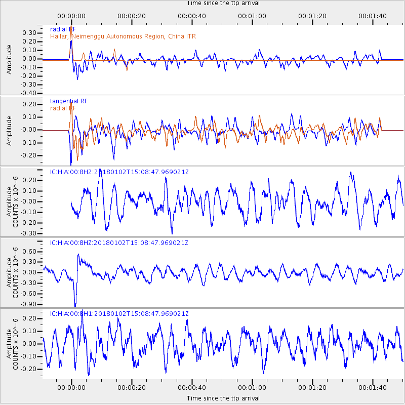
HIA Hailar, Neimenggu Autonomous Region, China - Earthquake Result Viewer
*The percent match for this event was below the threshold and hence no stack was calculated.
| Earthquake location: |
South Of Fiji Islands |
| Earthquake latitude/longitude: |
-24.8/178.5 |
| Earthquake time(UTC): |
2018/01/02 (002) 14:57:18 GMT |
| Earthquake Depth: |
577 km |
| Earthquake Magnitude: |
5.9 Mww |
| Earthquake Catalog/Contributor: |
NEIC PDE/us |
|
| Network: |
IC New China Digital Seismograph Network |
| Station: |
HIA Hailar, Neimenggu Autonomous Region, China |
| Lat/Lon: |
49.27 N/119.74 E |
| Elevation: |
620 m |
|
| Distance: |
90.4 deg |
| Az: |
325.958 deg |
| Baz: |
129.049 deg |
| Ray Param: |
$rayparam |
*The percent match for this event was below the threshold and hence was not used in the summary stack. |
|
| Radial Match: |
58.458305 % |
| Radial Bump: |
377 |
| Transverse Match: |
70.22719 % |
| Transverse Bump: |
400 |
| SOD ConfigId: |
2528331 |
| Insert Time: |
2018-01-16 14:58:20.665 +0000 |
| GWidth: |
2.5 |
| Max Bumps: |
400 |
| Tol: |
0.001 |
|
Signal To Noise
| Channel | StoN | STA | LTA |
| IC:HIA:00:BHZ:20180102T15:08:47.969021Z | 2.956929 | 4.2494676E-7 | 1.437122E-7 |
| IC:HIA:00:BH1:20180102T15:08:47.969021Z | 1.5614623 | 1.2099576E-7 | 7.748876E-8 |
| IC:HIA:00:BH2:20180102T15:08:47.969021Z | 1.0894719 | 1.3218614E-7 | 1.2133046E-7 |
| Arrivals |
| Ps | |
| PpPs | |
| PsPs/PpSs | |


