You are here: Home > Network List > G - GEOSCOPE Stations List
> Station TRIS Tristan da Cunha > Earthquake Result Viewer
TRIS Tristan da Cunha - Earthquake Result Viewer
| Earthquake location: |
Near Coast Of Peru |
| Earthquake latitude/longitude: |
-15.8/-74.7 |
| Earthquake time(UTC): |
2018/01/14 (014) 09:18:45 GMT |
| Earthquake Depth: |
36 km |
| Earthquake Magnitude: |
7.1 mww |
| Earthquake Catalog/Contributor: |
NEIC PDE/us |
|
| Network: |
G GEOSCOPE |
| Station: |
TRIS Tristan da Cunha |
| Lat/Lon: |
37.07 S/12.32 W |
| Elevation: |
60 m |
|
| Distance: |
58.8 deg |
| Az: |
123.977 deg |
| Baz: |
273.443 deg |
| Ray Param: |
0.06256704 |
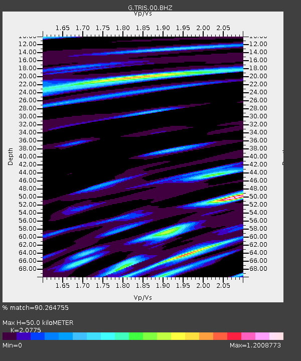
| Estimated Moho Depth: |
50.0 km |
| Estimated Crust Vp/Vs: |
2.08 |
| Assumed Crust Vp: |
4.24 km/s |
| Estimated Crust Vs: |
2.041 km/s |
| Estimated Crust Poisson's Ratio: |
0.35 |
|
| Radial Match: |
90.264755 % |
| Radial Bump: |
384 |
| Transverse Match: |
90.45222 % |
| Transverse Bump: |
394 |
| SOD ConfigId: |
2537391 |
| Insert Time: |
2018-01-28 09:20:17.852 +0000 |
| GWidth: |
2.5 |
| Max Bumps: |
400 |
| Tol: |
0.001 |
|

Signal To Noise
| Channel | StoN | STA | LTA |
| G:TRIS:00:BHZ:20180114T09:28:08.768975Z | 12.813527 | 1.7730765E-5 | 1.3837537E-6 |
| G:TRIS:00:BH1:20180114T09:28:08.768975Z | 1.347139 | 1.8993571E-6 | 1.4099193E-6 |
| G:TRIS:00:BH2:20180114T09:28:08.768975Z | 4.169308 | 8.019454E-6 | 1.9234496E-6 |
| Arrivals |
| Ps | 13 SECOND |
| PpPs | 36 SECOND |
| PsPs/PpSs | 49 SECOND |


