
Station G TRIS - Tristan da Cunha
Network: G - GEOSCOPE
Nearby stations (2 deg radius)
| Station | Name | (Lat, Lon) | Start / End | Elevation |
| TRIS | Tristan da Cunha | (-37.07, -12.32) | 2004-03-03 / 2599-12-31 | 60 m |
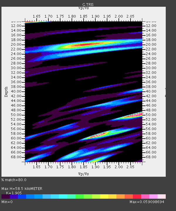
| Crust2 Type: | A0,normal oceanic, 0.07 km seds. |
| Thickness Estimate: | 58 km |
| Thickness StdDev: | 19 km |
| Vp/Vs Estimate: | 1.90 |
| Vp/Vs StdDev: | 0.13 |
| Vs Estimate: | 2.226 km/s |
| Poisson's Ratio: | 0.31 |
| Peak Value: | 0.06 |
| Assumed Vp: | 4.24 km/s |
| Ps Weight: | 0.33333334 |
| PpPs Weight: | 0.33333334 |
| PsPs Weight: | 0.33333328 |
| Residual Complexity: | 0.870 |
| Nearby stations H: | +- |
| (2.0 deg) Vp/Vs: | +- |
2 with match > 90% ( 8.333333 %) and 3 with match > 80% ( 12.5 %) out of 24.
Download stack as xyz text file.
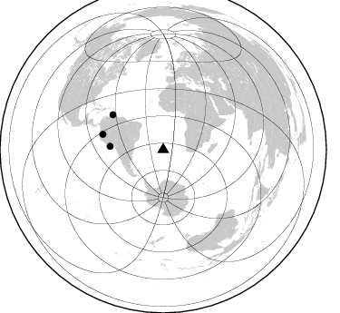
Azimuth Distribution of Events:
Prior Results for this Station
| Study | Thickness | Vp/Vs | Vp | Vs | Poissons Ratio | Extra |
| EARS | 58 km | 1.90 | 4.24 km/s | 2.226 km/s | 0.31 | |
| Crust2.0 | 12 km | 2.19 | 4.24 km/s | 1.94 km/s | 0.37 | A0,normal oceanic, 0.07 km seds. |
| Global Maxima | 58 km | 1.90 | 4.24 km/s | 2.226 km/s | 0.31 | amp=0.059098694 |
| Local Maxima 1 | 10 km | 1.61 | 4.24 km/s | 2.638 km/s | 0.18 | amp=0.04822434 |
| Local Maxima 2 | 20 km | 1.85 | 4.24 km/s | 2.295 km/s | 0.29 | amp=0.04803501 |
| Local Maxima 3 | 50 km | 2.08 | 4.24 km/s | 2.038 km/s | 0.35 | amp=0.04521178 |
| Local Maxima 4 | 70 km | 1.89 | 4.24 km/s | 2.243 km/s | 0.31 | amp=0.03921979 |
| Predicted Arrivals for vertical incidence (zero ray parameter) | |
| Ps | 12.49 SECOND |
| PpPs | 40.08 SECOND |
| PsPs/PpSs | 52.57 SECOND |
Events Processed for this Station
Download zip of receiver functions as SAC
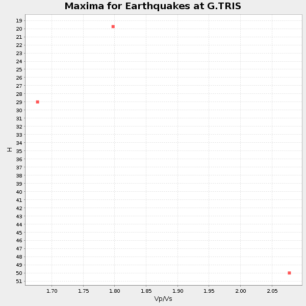
Plot maxima for each earthquake.
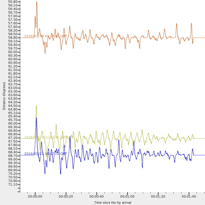
Events Used in the Stack
(3 events)| Radial Match | Distance | Baz | FERegion | Time | Lat/Lon | Depth | Magnitude |
| 90.6768 | 68.6 deg | 284.029 deg | Peru-Ecuador Border Region | 2019/02/22 10:17:22 GMT | (-2.2, -77.0) | 132 km | 7.5 mww |
| 90.264755 | 58.8 deg | 273.443 deg | Near Coast Of Peru | 2018/01/14 09:18:45 GMT | (-15.8, -74.7) | 36 km | 7.1 mww |
| 88.01508 | 67.2 deg | 304.637 deg | Near Coast Of Venezuela | 2018/08/21 21:31:46 GMT | (10.9, -62.9) | 154 km | 7.3 Mww |
Losers
(21 events)| Radial Match | Distance | Baz | FERegion | Time | Lat/Lon | Depth | Magnitude | Reason |
| 96.54745 | 46.9 deg | 242.082 deg | Southern Chile | 2016/12/25 14:22:28 GMT | (-43.3, -74.5) | 15 km | 7.7 Mi | |
| 90.438446 | 86.2 deg | 295.1 deg | North Of Honduras | 2018/01/10 02:51:31 GMT | (17.5, -83.6) | 33 km | 7.8 Mi | |
| 84.508705 | 89.8 deg | 44.352 deg | Iran-Iraq Border Region | 2017/11/12 18:18:17 GMT | (34.9, 46.0) | 19 km | 7.3 Mww | |
| 82.15241 | 41.6 deg | 115.931 deg | Prince Edward Islands Region | 2019/01/22 19:01:43 GMT | (-43.1, 42.3) | 13 km | 6.7 Mww | |
| 77.79657 | 58.4 deg | 280.533 deg | Peru-Brazil Border Region | 2018/08/24 09:04:06 GMT | (-11.0, -70.8) | 609 km | 7.1 Mww | |
| 67.09593 | 89.4 deg | 287.56 deg | Near Coast Of Guatemala | 2017/06/22 12:31:04 GMT | (13.7, -91.1) | 10 km | 6.8 Mi | |
| 65.34032 | 48.3 deg | 251.029 deg | Near Coast Of Central Chile | 2016/11/08 04:55:44 GMT | (-36.6, -73.6) | 17 km | 5.9 MO | |
| 64.535065 | 84.1 deg | 288.337 deg | Off Coast Of Costa Rica | 2018/01/16 15:03:54 GMT | (10.9, -86.3) | 31 km | 5.9 Mww | |
| 64.38695 | 46.3 deg | 259.272 deg | San Juan Province, Argentina | 2016/11/20 20:57:43 GMT | (-31.6, -68.8) | 116 km | 6.4 MWP, 6.5 MWB | |
| 61.983513 | 70.7 deg | 281.93 deg | Near Coast Of Ecuador | 2019/02/04 17:45:47 GMT | (-2.4, -79.9) | 70 km | 5.8 Mww | |
| 61.1748 | 46.8 deg | 275.952 deg | Southern Bolivia | 2018/04/02 13:40:34 GMT | (-20.7, -63.0) | 562 km | 6.8 Mww | |
| 58.80223 | 81.8 deg | 278.292 deg | Galapagos Islands Region | 2018/01/09 00:05:54 GMT | (1.7, -90.8) | 10 km | 5.8 Mww | |
| 57.604187 | 60.7 deg | 282.663 deg | Western Brazil | 2019/01/05 19:25:38 GMT | (-8.1, -71.6) | 575 km | 6.8 Mww | |
| 55.410263 | 81.8 deg | 288.413 deg | Costa Rica | 2017/11/13 02:28:23 GMT | (9.5, -84.5) | 19 km | 6.5 mww | |
| 53.98777 | 73.5 deg | 212.256 deg | Pacific-Antarctic Ridge | 2017/03/05 12:22:16 GMT | (-55.2, -129.2) | 10 km | 5.6 Mwb | |
| 53.096645 | 42.3 deg | 81.464 deg | Mozambique | 2016/09/22 20:06:11 GMT | (-21.5, 33.3) | 10 km | 5.5 MB | |
| 51.67494 | 48.4 deg | 256.157 deg | Off Coast Of Central Chile | 2017/04/24 21:46:04 GMT | (-33.0, -72.0) | 22 km | 5.0 mb | |
| 51.27332 | 70.4 deg | 213.971 deg | Southern East Pacific Rise | 2018/09/13 11:38:04 GMT | (-55.9, -123.2) | 10 km | 5.5 Mww | |
| 50.319893 | 66.5 deg | 281.223 deg | Northern Peru | 2016/09/10 10:08:20 GMT | (-5.6, -77.0) | 114 km | 6.0 MB | |
| 46.192642 | 66.1 deg | 306.374 deg | Windward Islands | 2016/12/06 21:42:21 GMT | (11.1, -60.9) | 35 km | 5.9 Mww | |
| 40.83315 | 72.2 deg | 283.259 deg | Near Coast Of Ecuador | 2017/12/03 11:19:06 GMT | (-0.5, -80.3) | 25 km | 6.0 Mww |

