You are here: Home > Network List > NM - Cooperative New Madrid Seismic Network Stations List
> Station HDBT Mud Island,Memphis,TN(CERI) > Earthquake Result Viewer
HDBT Mud Island,Memphis,TN(CERI) - Earthquake Result Viewer
| Earthquake location: |
Near Coast Of Peru |
| Earthquake latitude/longitude: |
-15.8/-74.7 |
| Earthquake time(UTC): |
2018/01/14 (014) 09:18:45 GMT |
| Earthquake Depth: |
36 km |
| Earthquake Magnitude: |
7.1 mww |
| Earthquake Catalog/Contributor: |
NEIC PDE/us |
|
| Network: |
NM Cooperative New Madrid Seismic Network |
| Station: |
HDBT Mud Island,Memphis,TN(CERI) |
| Lat/Lon: |
35.15 N/90.06 W |
| Elevation: |
66 m |
|
| Distance: |
52.7 deg |
| Az: |
344.212 deg |
| Baz: |
161.356 deg |
| Ray Param: |
0.06652518 |
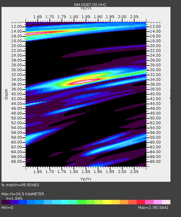
| Estimated Moho Depth: |
34.5 km |
| Estimated Crust Vp/Vs: |
1.85 |
| Assumed Crust Vp: |
6.273 km/s |
| Estimated Crust Vs: |
3.4 km/s |
| Estimated Crust Poisson's Ratio: |
0.29 |
|
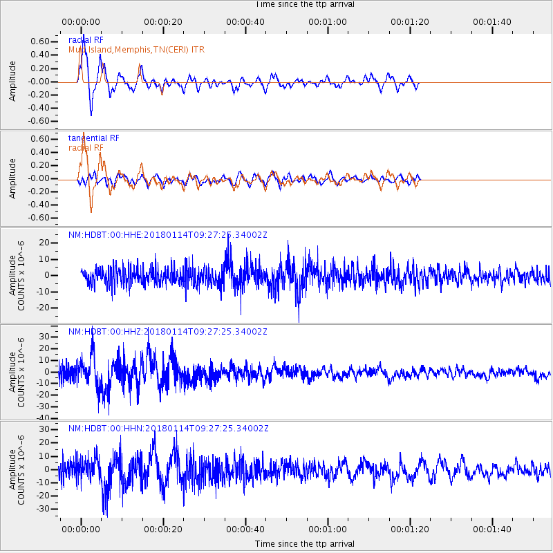
| Radial Match: |
89.90463 % |
| Radial Bump: |
309 |
| Transverse Match: |
56.96313 % |
| Transverse Bump: |
400 |
| SOD ConfigId: |
2537391 |
| Insert Time: |
2018-01-28 09:22:58.177 +0000 |
| GWidth: |
2.5 |
| Max Bumps: |
400 |
| Tol: |
0.001 |
|
Signal To Noise
| Channel | StoN | STA | LTA |
| NM:HDBT:00:HHZ:20180114T09:27:25.34002Z | 2.6335676 | 1.3772954E-5 | 5.2297705E-6 |
| NM:HDBT:00:HHN:20180114T09:27:25.34002Z | 1.2552128 | 8.04666E-6 | 6.4105943E-6 |
| NM:HDBT:00:HHE:20180114T09:27:25.34002Z | 1.0036834 | 4.696194E-6 | 4.6789596E-6 |
| Arrivals |
| Ps | 4.9 SECOND |
| PpPs | 15 SECOND |
| PsPs/PpSs | 20 SECOND |


