You are here: Home > Network List > AK - Alaska Regional Network Stations List
> Station D22K Ayikyak River, AK, USA > Earthquake Result Viewer
D22K Ayikyak River, AK, USA - Earthquake Result Viewer
| Earthquake location: |
Northern Molucca Sea |
| Earthquake latitude/longitude: |
2.9/126.5 |
| Earthquake time(UTC): |
2021/07/10 (191) 00:43:56 GMT |
| Earthquake Depth: |
45 km |
| Earthquake Magnitude: |
6.1 Mww |
| Earthquake Catalog/Contributor: |
NEIC PDE/us |
|
| Network: |
AK Alaska Regional Network |
| Station: |
D22K Ayikyak River, AK, USA |
| Lat/Lon: |
68.88 N/152.68 W |
| Elevation: |
532 m |
|
| Distance: |
84.0 deg |
| Az: |
21.087 deg |
| Baz: |
262.489 deg |
| Ray Param: |
0.045746118 |
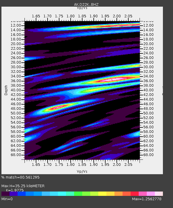
| Estimated Moho Depth: |
35.25 km |
| Estimated Crust Vp/Vs: |
1.98 |
| Assumed Crust Vp: |
6.221 km/s |
| Estimated Crust Vs: |
3.146 km/s |
| Estimated Crust Poisson's Ratio: |
0.33 |
|
| Radial Match: |
80.561295 % |
| Radial Bump: |
400 |
| Transverse Match: |
73.25229 % |
| Transverse Bump: |
400 |
| SOD ConfigId: |
25131211 |
| Insert Time: |
2021-07-24 00:44:54.869 +0000 |
| GWidth: |
2.5 |
| Max Bumps: |
400 |
| Tol: |
0.001 |
|

Signal To Noise
| Channel | StoN | STA | LTA |
| AK:D22K: :BHZ:20210710T00:55:50.300009Z | 15.901394 | 1.3148144E-6 | 8.268549E-8 |
| AK:D22K: :BHN:20210710T00:55:50.300009Z | 2.5858164 | 1.2698332E-7 | 4.9107634E-8 |
| AK:D22K: :BHE:20210710T00:55:50.300009Z | 7.482234 | 3.3697367E-7 | 4.5036504E-8 |
| Arrivals |
| Ps | 5.7 SECOND |
| PpPs | 17 SECOND |
| PsPs/PpSs | 22 SECOND |


