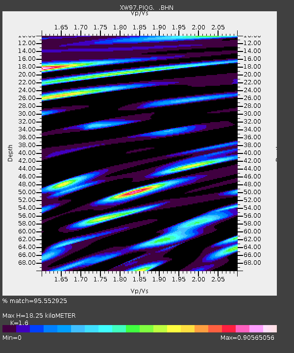
PIQG XW.PIQG - Earthquake Result Viewer

Earthquake location: Southern Sumatra, Indonesia
Earthquake latitude/longitude: -4.6/101.9
Earthquake time(UTC): 2000/06/07 (159) 23:45:26 GMT
Earthquake Depth: 33 km
Earthquake Magnitude: 6.1 MB, 6.7 MS, 6.7 MW, 6.5 MW
Earthquake Catalog/Contributor: WHDF/NEIC
Network: XW Tien Shan Continental Dynamics
Station: PIQG XW.PIQG
Lat/Lon: 40.32 N/77.63 E
Elevation: 1736 m
Distance: 50.0 deg
Az: 335.758 deg
Baz: 147.636 deg
Ray Param: 0.0683032
Estimated Moho Depth: 18.25 km
Estimated Crust Vp/Vs: 1.60
Assumed Crust Vp: 6.491 km/s
Estimated Crust Vs: 4.057 km/s
Estimated Crust Poisson's Ratio: 0.18
Radial Match: 95.552925 %
Radial Bump: 400
Transverse Match: 90.06178 %
Transverse Bump: 400
SOD ConfigId: 20082
Insert Time: 2010-02-26 15:44:38.907 +0000
GWidth: 2.5
Max Bumps: 400
Tol: 0.001

Signal To Noise

ChannelStoNSTALTA
XW:PIQG: :BHN:20000607T23:53:46.905006Z17.2863371.4299997E-68.272427E-8
XW:PIQG: :BHE:20000607T23:53:46.905006Z5.79789927.866919E-71.3568568E-7
XW:PIQG: :BHZ:20000607T23:53:46.905006Z44.117634.301316E-69.749653E-8
Arrivals
Ps1.8 SECOND
PpPs6.8 SECOND
PsPs/PpSs8.6 SECOND