
Station XW PIQG - XW.PIQG
Network: XW97 - Tien Shan Continental Dynamics
Nearby stations (2 deg radius)

| Station | Name | (Lat, Lon) | Start / End | Elevation |
| PIQG | XW.PIQG | (40.32, 77.63) | 1999-06-20 / 2002-01-01 | 1736 m |
| Crust2 Type: | R4,orogen/55km Tibet Transition, 0 km seds. |
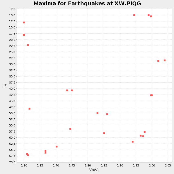
| Thickness Estimate: | 61 km |
| Thickness StdDev: | 14 km |
| Vp/Vs Estimate: | 1.95 |
| Vp/Vs StdDev: | 0.14 |
| Vs Estimate: | 3.329 km/s |
| Poisson's Ratio: | 0.32 |
| Peak Value: | 0.01 |
| Assumed Vp: | 6.491 km/s |
| Ps Weight: | 0.33333334 |
| PpPs Weight: | 0.33333334 |
| PsPs Weight: | 0.33333328 |
| Residual Complexity: | 0.858 |
| Nearby stations H: | +- |
| (2.0 deg) Vp/Vs: | +- |
10 with match > 90% ( 37.037037 %) and 27 with match > 80% ( 100.0 %) out of 27.
Download stack as xyz text file.
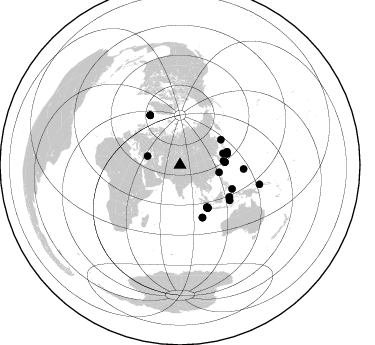
Azimuth Distribution of Events:
Prior Results for this Station
| Study | Thickness | Vp/Vs | Vp | Vs | Poissons Ratio | Extra |
| EARS | 61 km | 1.95 | 6.491 km/s | 3.329 km/s | 0.32 | |
| Crust2.0 | 55 km | 1.76 | 6.491 km/s | 3.696 km/s | 0.26 | R4,orogen/55km Tibet Transition, 0 km seds. |
| Global Maxima | 61 km | 1.95 | 6.491 km/s | 3.329 km/s | 0.32 | amp=0.014235188 |
| Local Maxima 1 | 25 km | 1.60 | 6.491 km/s | 4.057 km/s | 0.18 | amp=0.01262217 |
| Local Maxima 2 | 57 km | 1.74 | 6.491 km/s | 3.73 km/s | 0.25 | amp=0.011998393 |
| Local Maxima 3 | 51 km | 1.85 | 6.491 km/s | 3.504 km/s | 0.29 | amp=0.010641768 |
| Local Maxima 4 | 70 km | 1.86 | 6.491 km/s | 3.499 km/s | 0.30 | amp=0.00852303 |
| Predicted Arrivals for vertical incidence (zero ray parameter) | |
| Ps | 8.93 SECOND |
| PpPs | 27.72 SECOND |
| PsPs/PpSs | 36.65 SECOND |
Events Processed for this Station
Download zip of receiver functions as SAC
Plot maxima for each earthquake.
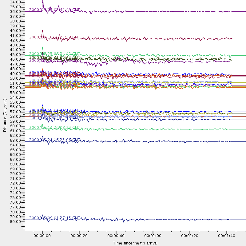
Events Used in the Stack
(27 events)| Radial Match | Distance | Baz | FERegion | Time | Lat/Lon | Depth | Magnitude |
| 95.910255 | 50.1 deg | 147.479 deg | Southern Sumatra, Indonesia | 2000/06/04 16:28:26 GMT | (-4.7, 102.1) | 33 km | 6.8 MB, 8.0 MS, 7.9 MW, 7.7 MW |
| 95.63491 | 56.9 deg | 156.841 deg | South Indian Ocean | 2000/06/18 14:44:13 GMT | (-13.8, 97.5) | 10 km | 6.8 MB, 7.8 MS, 7.8 MW, 7.6 MW |
| 95.552925 | 50.0 deg | 147.636 deg | Southern Sumatra, Indonesia | 2000/06/07 23:45:26 GMT | (-4.6, 101.9) | 33 km | 6.1 MB, 6.7 MS, 6.7 MW, 6.5 MW |
| 95.39994 | 50.7 deg | 146.958 deg | Southern Sumatra, Indonesia | 2000/06/06 09:58:06 GMT | (-5.1, 102.7) | 33 km | 5.8 MB, 6.1 MS, 6.2 MW, 6.1 MW |
| 93.5681 | 33.7 deg | 285.468 deg | Turkey | 2000/06/06 02:41:49 GMT | (40.7, 33.0) | 10 km | 5.5 MB, 6.1 MS, 6.1 MW, 6.0 MW |
| 93.09649 | 51.1 deg | 147.225 deg | Southern Sumatra, Indonesia | 2000/06/09 08:00:24 GMT | (-5.5, 102.7) | 33 km | 5.8 MB, 5.8 MS, 6.0 MW, 6.0 MW |
| 91.10201 | 48.2 deg | 58.563 deg | Sea Of Okhotsk | 2000/07/10 09:58:18 GMT | (46.8, 145.4) | 360 km | 6.1 MB, 5.9 MW, 5.8 MW |
| 90.898445 | 51.0 deg | 147.126 deg | Southern Sumatra, Indonesia | 2000/07/08 04:52:55 GMT | (-5.4, 102.7) | 33 km | 5.7 MB, 5.7 MS, 5.9 MW, 5.8 MW |
| 90.707344 | 48.5 deg | 76.621 deg | Near S. Coast Of Honshu, Japan | 2000/07/01 07:01:55 GMT | (34.2, 139.1) | 10 km | 6.0 MB, 6.1 MS, 6.2 MW, 6.2 MW |
| 90.16089 | 58.7 deg | 122.781 deg | Sulawesi, Indonesia | 2000/05/04 04:21:16 GMT | (-1.1, 123.6) | 26 km | 6.7 MB, 7.5 MS, 7.6 MW, 7.5 ME |
| 89.44583 | 48.9 deg | 74.394 deg | Near East Coast Of Honshu, Japan | 2000/06/03 08:54:49 GMT | (35.6, 140.5) | 62 km | 5.6 MB, 5.6 MS, 6.1 MW, 6.1 MW |
| 89.022415 | 44.7 deg | 75.075 deg | Sea Of Japan | 2000/06/06 21:16:42 GMT | (36.8, 135.5) | 10 km | 5.7 MB, 5.3 MS, 5.9 MW, 5.8 MW |
| 88.68859 | 48.5 deg | 76.824 deg | Near S. Coast Of Honshu, Japan | 2000/07/08 18:57:44 GMT | (34.1, 139.1) | 10 km | 5.9 MB, 5.6 MS, 6.0 MW, 5.9 MW |
| 88.67409 | 57.9 deg | 328.971 deg | Iceland | 2000/06/17 15:40:41 GMT | (64.0, -20.5) | 10 km | 5.7 MB, 6.6 MS, 6.8 MW, 6.5 MW |
| 88.48832 | 58.0 deg | 329.05 deg | Iceland | 2000/06/21 00:51:46 GMT | (64.0, -20.8) | 10 km | 6.1 MB, 6.6 MS, 6.5 MW, 6.4 MW |
| 88.22506 | 57.2 deg | 156.815 deg | South Indian Ocean | 2000/06/20 11:34:00 GMT | (-14.1, 97.6) | 10 km | 5.6 MB, 5.6 MS, 6.1 MW, 5.8 MW |
| 88.16761 | 40.0 deg | 100.766 deg | Taiwan | 2000/06/10 18:23:29 GMT | (23.8, 121.2) | 33 km | 6.2 MB, 6.2 MS, 6.4 MW, 6.3 MW |
| 87.98336 | 60.9 deg | 125.47 deg | Banda Sea | 2000/05/14 20:08:34 GMT | (-4.3, 123.2) | 33 km | 5.9 MB, 5.9 MS, 6.3 MW, 6.2 MW |
| 87.63543 | 51.3 deg | 147.014 deg | Southern Sumatra, Indonesia | 2000/06/05 03:00:26 GMT | (-5.6, 102.9) | 33 km | 5.5 MB, 5.5 MS, 5.8 MW, 5.8 MW |
| 86.2131 | 58.0 deg | 329.004 deg | Iceland | 2000/06/17 15:42:52 GMT | (64.0, -20.6) | 10 km | 5.7 MB |
| 86.20122 | 50.5 deg | 146.91 deg | Southern Sumatra, Indonesia | 2000/06/05 06:34:11 GMT | (-4.9, 102.7) | 33 km | 5.4 MB, 5.5 MS, 5.8 MW |
| 85.533714 | 43.9 deg | 84.536 deg | Kyushu, Japan | 2000/06/25 06:34:42 GMT | (31.2, 131.2) | 10 km | 5.8 MB, 5.7 MS, 6.2 MW, 5.9 MW |
| 84.1289 | 57.3 deg | 114.72 deg | Talaud Islands, Indonesia | 2000/06/14 17:00:48 GMT | (4.5, 127.7) | 90 km | 6.1 MB, 5.6 MS, 6.4 MW, 6.3 MW |
| 83.48257 | 63.8 deg | 93.562 deg | Mariana Islands | 2000/06/21 16:25:06 GMT | (14.1, 145.0) | 112 km | 5.7 MB, 6.0 MW, 5.9 MW |
| 83.47962 | 81.8 deg | 103.718 deg | New Britain Region, P.N.G. | 2000/06/09 01:27:15 GMT | (-5.1, 152.5) | 33 km | 5.4 MB, 6.3 MS, 6.3 MW, 6.3 MW |
| 80.41645 | 45.4 deg | 86.296 deg | Southeast Of Shikoku, Japan | 2000/06/15 11:10:46 GMT | (29.4, 132.1) | 10 km | 6.0 MB, 5.6 MS, 6.1 MW, 6.1 MW |
| 80.17497 | 44.8 deg | 86.622 deg | Southeast Of Ryukyu Islands | 2000/06/06 14:57:02 GMT | (29.4, 131.4) | 33 km | 5.8 MB, 6.0 MS, 6.4 MW, 6.4 MW |
Losers
(0 events)| Radial Match | Distance | Baz | FERegion | Time | Lat/Lon | Depth | Magnitude | Reason |
