You are here: Home > Network List > XW97 - Tien Shan Continental Dynamics Stations List
> Station TERE XW.TERE > Earthquake Result Viewer
TERE XW.TERE - Earthquake Result Viewer

| Earthquake location: |
Southern Sumatra, Indonesia |
| Earthquake latitude/longitude: |
-4.1/102.4 |
| Earthquake time(UTC): |
2000/07/22 (204) 20:56:12 GMT |
| Earthquake Depth: |
69 km |
| Earthquake Magnitude: |
5.8 MB, 5.8 MW, 5.7 MW |
| Earthquake Catalog/Contributor: |
WHDF/NEIC |
|
| Network: |
XW Tien Shan Continental Dynamics |
| Station: |
TERE XW.TERE |
| Lat/Lon: |
40.48 N/75.77 E |
| Elevation: |
3684 m |
|
| Distance: |
50.6 deg |
| Az: |
333.766 deg |
| Baz: |
144.689 deg |
| Ray Param: |
0.06774851 |
| Estimated Moho Depth: |
66.25 km |
| Estimated Crust Vp/Vs: |
1.60 |
| Assumed Crust Vp: |
6.491 km/s |
| Estimated Crust Vs: |
4.057 km/s |
| Estimated Crust Poisson's Ratio: |
0.18 |
|
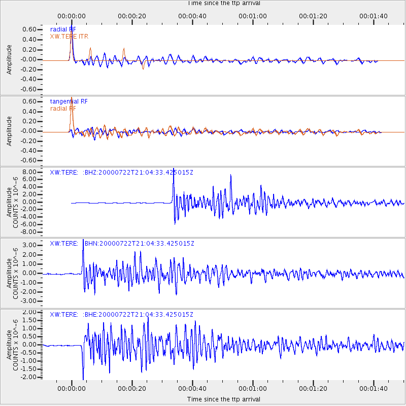
| Radial Match: |
96.392006 % |
| Radial Bump: |
400 |
| Transverse Match: |
93.37979 % |
| Transverse Bump: |
400 |
| SOD ConfigId: |
20082 |
| Insert Time: |
2010-02-26 15:46:08.254 +0000 |
| GWidth: |
2.5 |
| Max Bumps: |
400 |
| Tol: |
0.001 |
|
Signal To Noise
| Channel | StoN | STA | LTA |
| XW:TERE: :BHN:20000722T21:04:33.425015Z | 41.400528 | 9.31546E-7 | 2.2500824E-8 |
| XW:TERE: :BHE:20000722T21:04:33.425015Z | 18.369278 | 5.123127E-7 | 2.7889646E-8 |
| XW:TERE: :BHZ:20000722T21:04:33.425015Z | 59.414257 | 2.3663083E-6 | 3.9827285E-8 |
| Arrivals |
| Ps | 6.5 SECOND |
| PpPs | 25 SECOND |
| PsPs/PpSs | 31 SECOND |


