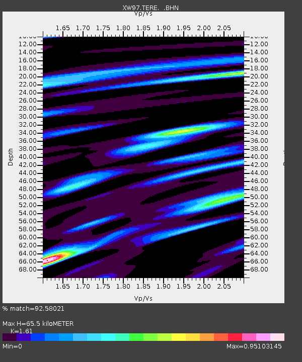
TERE XW.TERE - Earthquake Result Viewer

Earthquake location: Southern Sumatra, Indonesia
Earthquake latitude/longitude: -5.4/102.7
Earthquake time(UTC): 2000/07/08 (190) 04:52:55 GMT
Earthquake Depth: 33 km
Earthquake Magnitude: 5.7 MB, 5.7 MS, 5.9 MW, 5.8 MW
Earthquake Catalog/Contributor: WHDF/NEIC
Network: XW Tien Shan Continental Dynamics
Station: TERE XW.TERE
Lat/Lon: 40.48 N/75.77 E
Elevation: 3684 m
Distance: 51.9 deg
Az: 333.972 deg
Baz: 145.06 deg
Ray Param: 0.06702476
Estimated Moho Depth: 65.5 km
Estimated Crust Vp/Vs: 1.61
Assumed Crust Vp: 6.491 km/s
Estimated Crust Vs: 4.032 km/s
Estimated Crust Poisson's Ratio: 0.19
Radial Match: 92.58021 %
Radial Bump: 387
Transverse Match: 88.53125 %
Transverse Bump: 400
SOD ConfigId: 20082
Insert Time: 2010-02-26 15:46:17.608 +0000
GWidth: 2.5
Max Bumps: 400
Tol: 0.001

Signal To Noise

ChannelStoNSTALTA
XW:TERE: :BHN:20000708T05:01:30.399014Z7.77544.943094E-76.35735E-8
XW:TERE: :BHE:20000708T05:01:30.399014Z11.4603233.7980743E-73.3141074E-8
XW:TERE: :BHZ:20000708T05:01:30.399014Z18.9794711.2246375E-66.452432E-8
Arrivals
Ps6.6 SECOND
PpPs25 SECOND
PsPs/PpSs31 SECOND