You are here: Home > Network List > XW97 - Tien Shan Continental Dynamics Stations List
> Station TERE XW.TERE > Earthquake Result Viewer
TERE XW.TERE - Earthquake Result Viewer
| Earthquake location: |
Mariana Islands |
| Earthquake latitude/longitude: |
14.1/145.0 |
| Earthquake time(UTC): |
2000/06/21 (173) 16:25:06 GMT |
| Earthquake Depth: |
112 km |
| Earthquake Magnitude: |
5.7 MB, 6.0 MW, 5.9 MW |
| Earthquake Catalog/Contributor: |
WHDF/NEIC |
|
| Network: |
XW Tien Shan Continental Dynamics |
| Station: |
TERE XW.TERE |
| Lat/Lon: |
40.48 N/75.77 E |
| Elevation: |
3684 m |
|
| Distance: |
65.2 deg |
| Az: |
308.227 deg |
| Baz: |
92.403 deg |
| Ray Param: |
0.058128543 |
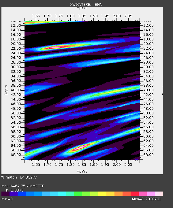
| Estimated Moho Depth: |
64.75 km |
| Estimated Crust Vp/Vs: |
1.84 |
| Assumed Crust Vp: |
6.491 km/s |
| Estimated Crust Vs: |
3.532 km/s |
| Estimated Crust Poisson's Ratio: |
0.29 |
|
| Radial Match: |
84.83277 % |
| Radial Bump: |
400 |
| Transverse Match: |
69.72948 % |
| Transverse Bump: |
400 |
| SOD ConfigId: |
20082 |
| Insert Time: |
2010-02-26 15:46:22.743 +0000 |
| GWidth: |
2.5 |
| Max Bumps: |
400 |
| Tol: |
0.001 |
|

Signal To Noise
| Channel | StoN | STA | LTA |
| XW:TERE: :BHN:20000621T16:35:04.824009Z | 0.99164134 | 3.993022E-8 | 4.0266798E-8 |
| XW:TERE: :BHE:20000621T16:35:04.824009Z | 2.4068913 | 3.9326643E-8 | 1.6339186E-8 |
| XW:TERE: :BHZ:20000621T16:35:04.824009Z | 1.9719528 | 1.10676304E-7 | 5.612523E-8 |
| Arrivals |
| Ps | 8.7 SECOND |
| PpPs | 27 SECOND |
| PsPs/PpSs | 36 SECOND |


