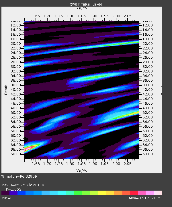
TERE XW.TERE - Earthquake Result Viewer
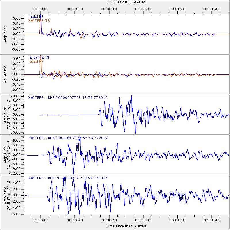
Earthquake location: Southern Sumatra, Indonesia
Earthquake latitude/longitude: -4.6/101.9
Earthquake time(UTC): 2000/06/07 (159) 23:45:26 GMT
Earthquake Depth: 33 km
Earthquake Magnitude: 6.1 MB, 6.7 MS, 6.7 MW, 6.5 MW
Earthquake Catalog/Contributor: WHDF/NEIC
Network: XW Tien Shan Continental Dynamics
Station: TERE XW.TERE
Lat/Lon: 40.48 N/75.77 E
Elevation: 3684 m
Distance: 50.9 deg
Az: 334.335 deg
Baz: 145.531 deg
Ray Param: 0.067705505
Estimated Moho Depth: 65.75 km
Estimated Crust Vp/Vs: 1.61
Assumed Crust Vp: 6.491 km/s
Estimated Crust Vs: 4.044 km/s
Estimated Crust Poisson's Ratio: 0.18
Radial Match: 96.62909 %
Radial Bump: 370
Transverse Match: 89.51404 %
Transverse Bump: 400
SOD ConfigId: 20082
Insert Time: 2010-02-26 15:46:35.477 +0000
GWidth: 2.5
Max Bumps: 400
Tol: 0.001

Signal To Noise

ChannelStoNSTALTA
XW:TERE: :BHN:20000607T23:53:53.77201Z14.6461226.480297E-74.4245823E-8
XW:TERE: :BHE:20000607T23:53:53.77201Z5.30286034.0097294E-77.5614466E-8
XW:TERE: :BHZ:20000607T23:53:53.77201Z23.5190221.4227959E-66.049554E-8
Arrivals
Ps6.5 SECOND
PpPs25 SECOND
PsPs/PpSs31 SECOND