You are here: Home > Network List > XW97 - Tien Shan Continental Dynamics Stations List
> Station TERE XW.TERE > Earthquake Result Viewer
TERE XW.TERE - Earthquake Result Viewer
| Earthquake location: |
Southern Sumatra, Indonesia |
| Earthquake latitude/longitude: |
-4.9/102.7 |
| Earthquake time(UTC): |
2000/06/05 (157) 06:34:11 GMT |
| Earthquake Depth: |
33 km |
| Earthquake Magnitude: |
5.4 MB, 5.5 MS, 5.8 MW |
| Earthquake Catalog/Contributor: |
WHDF/NEIC |
|
| Network: |
XW Tien Shan Continental Dynamics |
| Station: |
TERE XW.TERE |
| Lat/Lon: |
40.48 N/75.77 E |
| Elevation: |
3684 m |
|
| Distance: |
51.5 deg |
| Az: |
333.835 deg |
| Baz: |
144.833 deg |
| Ray Param: |
0.06733324 |
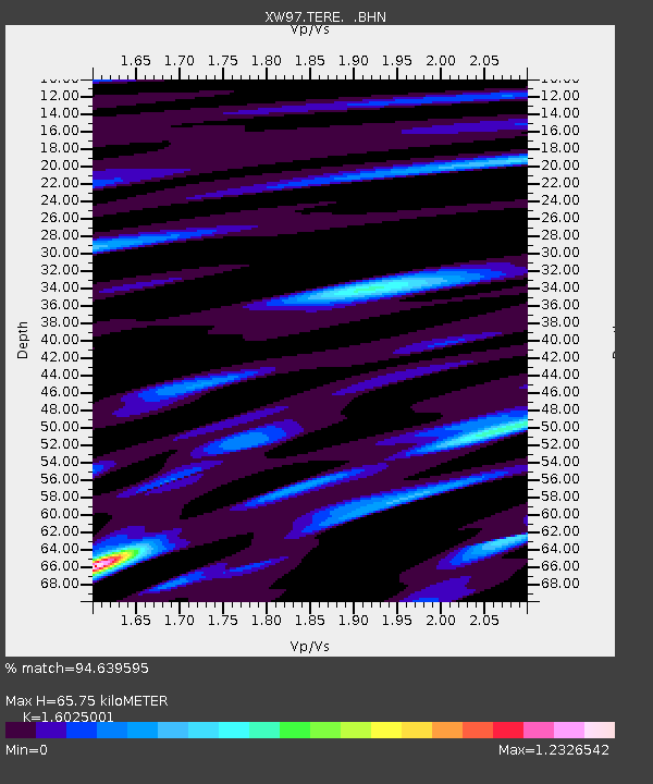
| Estimated Moho Depth: |
65.75 km |
| Estimated Crust Vp/Vs: |
1.60 |
| Assumed Crust Vp: |
6.491 km/s |
| Estimated Crust Vs: |
4.05 km/s |
| Estimated Crust Poisson's Ratio: |
0.18 |
|
| Radial Match: |
94.639595 % |
| Radial Bump: |
335 |
| Transverse Match: |
89.41555 % |
| Transverse Bump: |
400 |
| SOD ConfigId: |
20082 |
| Insert Time: |
2010-02-26 15:46:39.912 +0000 |
| GWidth: |
2.5 |
| Max Bumps: |
400 |
| Tol: |
0.001 |
|

Signal To Noise
| Channel | StoN | STA | LTA |
| XW:TERE: :BHN:20000605T06:42:43.348015Z | 11.343782 | 2.9073783E-7 | 2.5629708E-8 |
| XW:TERE: :BHE:20000605T06:42:43.348015Z | 9.706605 | 2.0676787E-7 | 2.130177E-8 |
| XW:TERE: :BHZ:20000605T06:42:43.348015Z | 14.093519 | 6.0953886E-7 | 4.3249585E-8 |
| Arrivals |
| Ps | 6.5 SECOND |
| PpPs | 25 SECOND |
| PsPs/PpSs | 31 SECOND |


