You are here: Home > Network List > XW97 - Tien Shan Continental Dynamics Stations List
> Station TERE XW.TERE > Earthquake Result Viewer
TERE XW.TERE - Earthquake Result Viewer
| Earthquake location: |
Southern Alaska |
| Earthquake latitude/longitude: |
59.2/-153.1 |
| Earthquake time(UTC): |
2000/05/19 (140) 20:34:26 GMT |
| Earthquake Depth: |
80 km |
| Earthquake Magnitude: |
5.6 MB, 5.9 MW, 5.9 MW |
| Earthquake Catalog/Contributor: |
WHDF/NEIC |
|
| Network: |
XW Tien Shan Continental Dynamics |
| Station: |
TERE XW.TERE |
| Lat/Lon: |
40.48 N/75.77 E |
| Elevation: |
3684 m |
|
| Distance: |
72.8 deg |
| Az: |
322.987 deg |
| Baz: |
23.957 deg |
| Ray Param: |
0.053274292 |
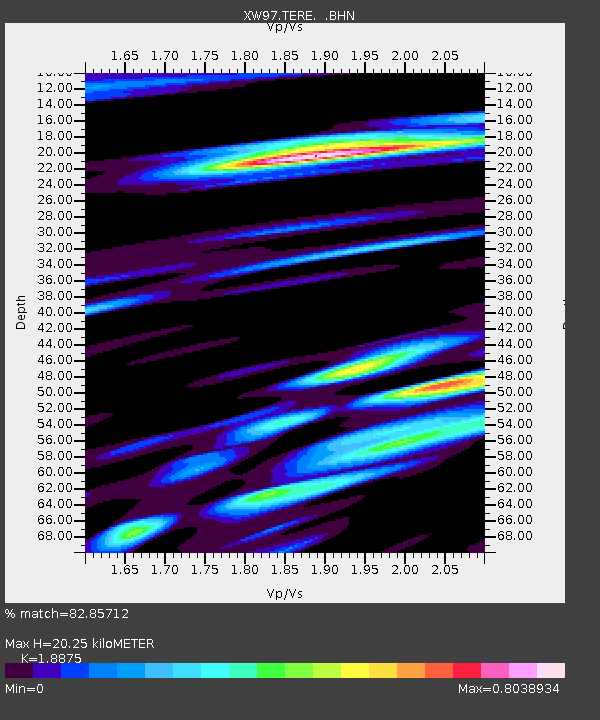
| Estimated Moho Depth: |
20.25 km |
| Estimated Crust Vp/Vs: |
1.89 |
| Assumed Crust Vp: |
6.491 km/s |
| Estimated Crust Vs: |
3.439 km/s |
| Estimated Crust Poisson's Ratio: |
0.30 |
|
| Radial Match: |
82.85712 % |
| Radial Bump: |
400 |
| Transverse Match: |
80.66098 % |
| Transverse Bump: |
400 |
| SOD ConfigId: |
20082 |
| Insert Time: |
2010-02-26 15:46:49.263 +0000 |
| GWidth: |
2.5 |
| Max Bumps: |
400 |
| Tol: |
0.001 |
|

Signal To Noise
| Channel | StoN | STA | LTA |
| XW:TERE: :BHN:20000519T20:45:14.82302Z | 3.9611247 | 1.5874735E-7 | 4.0076333E-8 |
| XW:TERE: :BHE:20000519T20:45:14.82302Z | 1.6207416 | 6.104068E-8 | 3.7662193E-8 |
| XW:TERE: :BHZ:20000519T20:45:14.82302Z | 8.915412 | 4.121295E-7 | 4.6226635E-8 |
| Arrivals |
| Ps | 2.9 SECOND |
| PpPs | 8.7 SECOND |
| PsPs/PpSs | 12 SECOND |


