You are here: Home > Network List > XW97 - Tien Shan Continental Dynamics Stations List
> Station TERE XW.TERE > Earthquake Result Viewer
TERE XW.TERE - Earthquake Result Viewer
| Earthquake location: |
Banda Sea |
| Earthquake latitude/longitude: |
-7.0/128.9 |
| Earthquake time(UTC): |
2000/07/15 (197) 07:13:44 GMT |
| Earthquake Depth: |
218 km |
| Earthquake Magnitude: |
5.6 MB, 5.9 MW, 5.9 MW |
| Earthquake Catalog/Contributor: |
WHDF/NEIC |
|
| Network: |
XW Tien Shan Continental Dynamics |
| Station: |
TERE XW.TERE |
| Lat/Lon: |
40.48 N/75.77 E |
| Elevation: |
3684 m |
|
| Distance: |
67.9 deg |
| Az: |
318.801 deg |
| Baz: |
121.012 deg |
| Ray Param: |
0.055992655 |
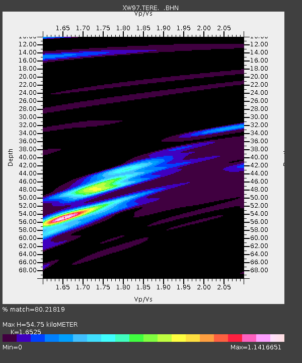
| Estimated Moho Depth: |
54.75 km |
| Estimated Crust Vp/Vs: |
1.65 |
| Assumed Crust Vp: |
6.491 km/s |
| Estimated Crust Vs: |
3.928 km/s |
| Estimated Crust Poisson's Ratio: |
0.21 |
|
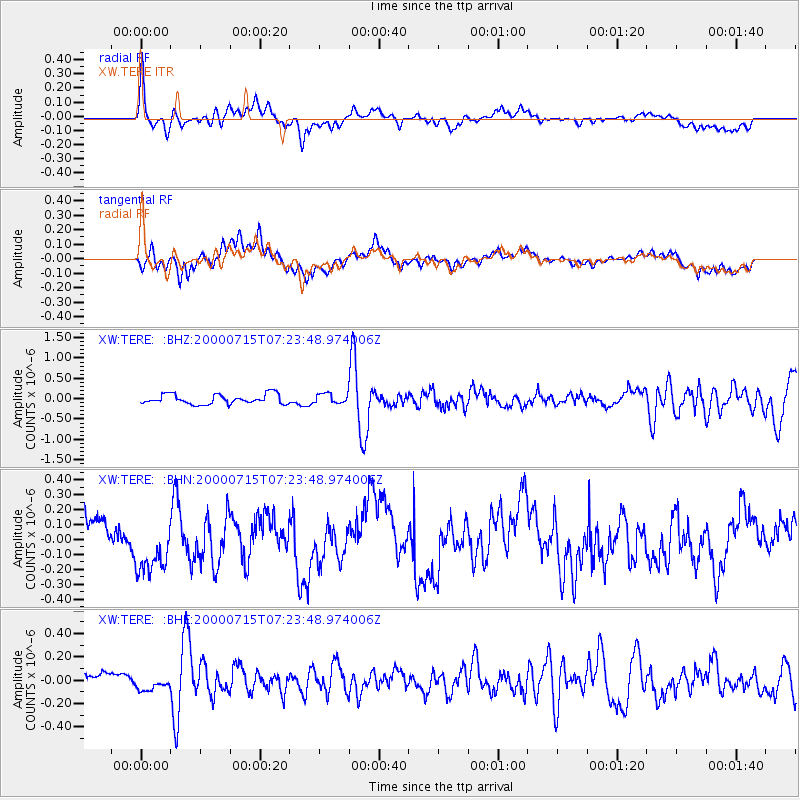
| Radial Match: |
80.21819 % |
| Radial Bump: |
400 |
| Transverse Match: |
58.881626 % |
| Transverse Bump: |
400 |
| SOD ConfigId: |
16820 |
| Insert Time: |
2010-02-26 15:47:10.553 +0000 |
| GWidth: |
2.5 |
| Max Bumps: |
400 |
| Tol: |
0.001 |
|
Signal To Noise
| Channel | StoN | STA | LTA |
| XW:TERE: :BHN:20000715T07:23:48.974006Z | 1.4056469 | 1.5321116E-7 | 1.089969E-7 |
| XW:TERE: :BHE:20000715T07:23:48.974006Z | 1.4399924 | 6.4674694E-8 | 4.4913218E-8 |
| XW:TERE: :BHZ:20000715T07:23:48.974006Z | 1.0135711 | 1.2198848E-7 | 1.2035511E-7 |
| Arrivals |
| Ps | 5.7 SECOND |
| PpPs | 21 SECOND |
| PsPs/PpSs | 27 SECOND |


