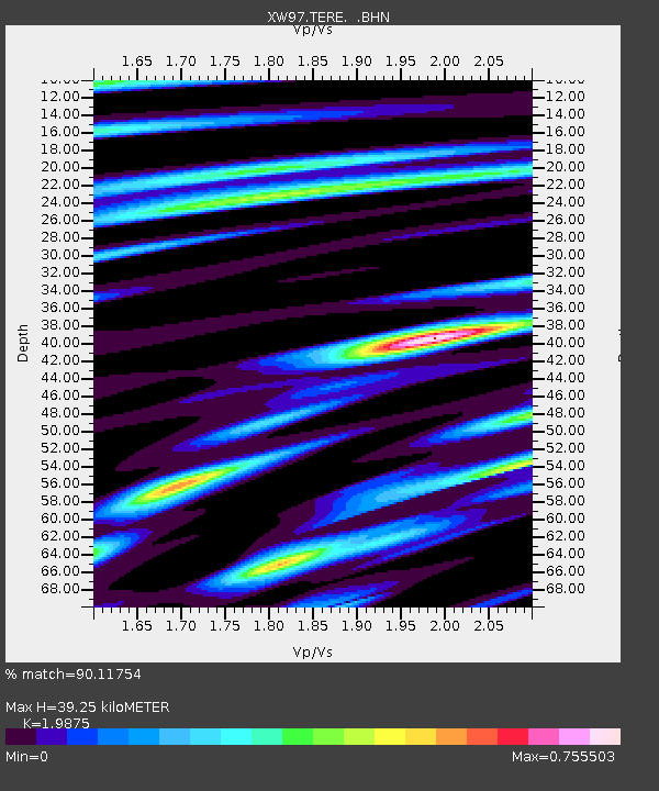
TERE XW.TERE - Earthquake Result Viewer
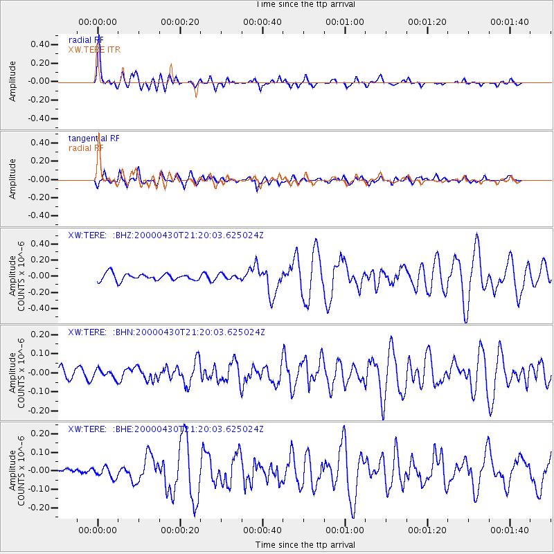
Earthquake location: Bismarck Sea
Earthquake latitude/longitude: -4.0/146.6
Earthquake time(UTC): 2000/04/30 (121) 21:08:35 GMT
Earthquake Depth: 10 km
Earthquake Magnitude: 5.3 MB, 5.7 MS, 5.9 MW, 5.9 MW
Earthquake Catalog/Contributor: WHDF/NEIC
Network: XW Tien Shan Continental Dynamics
Station: TERE XW.TERE
Lat/Lon: 40.48 N/75.77 E
Elevation: 3684 m
Distance: 78.1 deg
Az: 312.601 deg
Baz: 105.71 deg
Ray Param: 0.049856458
Estimated Moho Depth: 39.25 km
Estimated Crust Vp/Vs: 1.99
Assumed Crust Vp: 6.491 km/s
Estimated Crust Vs: 3.266 km/s
Estimated Crust Poisson's Ratio: 0.33
Radial Match: 90.11754 %
Radial Bump: 400
Transverse Match: 77.40814 %
Transverse Bump: 400
SOD ConfigId: 16820
Insert Time: 2010-02-26 15:47:16.360 +0000
GWidth: 2.5
Max Bumps: 400
Tol: 0.001

Signal To Noise

ChannelStoNSTALTA
XW:TERE: :BHN:20000430T21:20:03.625024Z0.95882562.200392E-82.2948825E-8
XW:TERE: :BHE:20000430T21:20:03.625024Z2.10656672.9737144E-81.4116403E-8
XW:TERE: :BHZ:20000430T21:20:03.625024Z0.69136563.0114975E-84.3558682E-8
Arrivals
Ps6.1 SECOND
PpPs18 SECOND
PsPs/PpSs24 SECOND