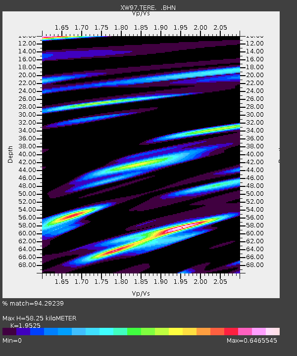
TERE XW.TERE - Earthquake Result Viewer

Earthquake location: North Of Halmahera, Indonesia
Earthquake latitude/longitude: 3.2/128.0
Earthquake time(UTC): 2000/03/21 (081) 05:26:07 GMT
Earthquake Depth: 103 km
Earthquake Magnitude: 6.1 MB, 5.3 MS, 6.0 MW, 5.9 MW
Earthquake Catalog/Contributor: WHDF/NEIC
Network: XW Tien Shan Continental Dynamics
Station: TERE XW.TERE
Lat/Lon: 40.48 N/75.77 E
Elevation: 3684 m
Distance: 59.9 deg
Az: 315.789 deg
Baz: 114.114 deg
Ray Param: 0.061591767
Estimated Moho Depth: 58.25 km
Estimated Crust Vp/Vs: 1.95
Assumed Crust Vp: 6.491 km/s
Estimated Crust Vs: 3.324 km/s
Estimated Crust Poisson's Ratio: 0.32
Radial Match: 94.29239 %
Radial Bump: 400
Transverse Match: 89.46091 %
Transverse Bump: 400
SOD ConfigId: 16820
Insert Time: 2010-02-26 15:47:18.864 +0000
GWidth: 2.5
Max Bumps: 400
Tol: 0.001

Signal To Noise

ChannelStoNSTALTA
XW:TERE: :BHN:20000321T05:35:32.124011Z1.26018378.8249905E-87.0029394E-8
XW:TERE: :BHE:20000321T05:35:32.124011Z0.443803764.464663E-81.00599934E-7
XW:TERE: :BHZ:20000321T05:35:32.124011Z1.07670389.9868856E-89.275425E-8
Arrivals
Ps8.9 SECOND
PpPs25 SECOND
PsPs/PpSs34 SECOND