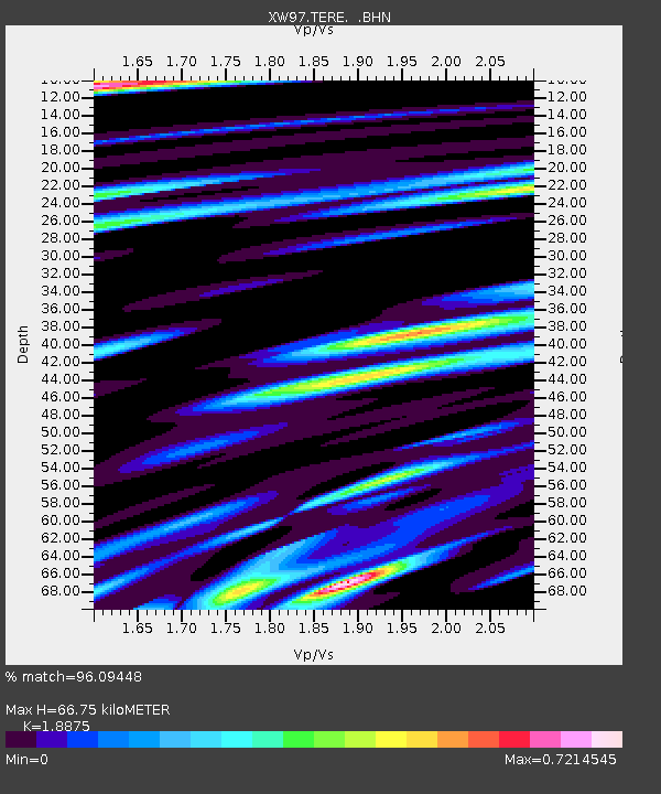
TERE XW.TERE - Earthquake Result Viewer
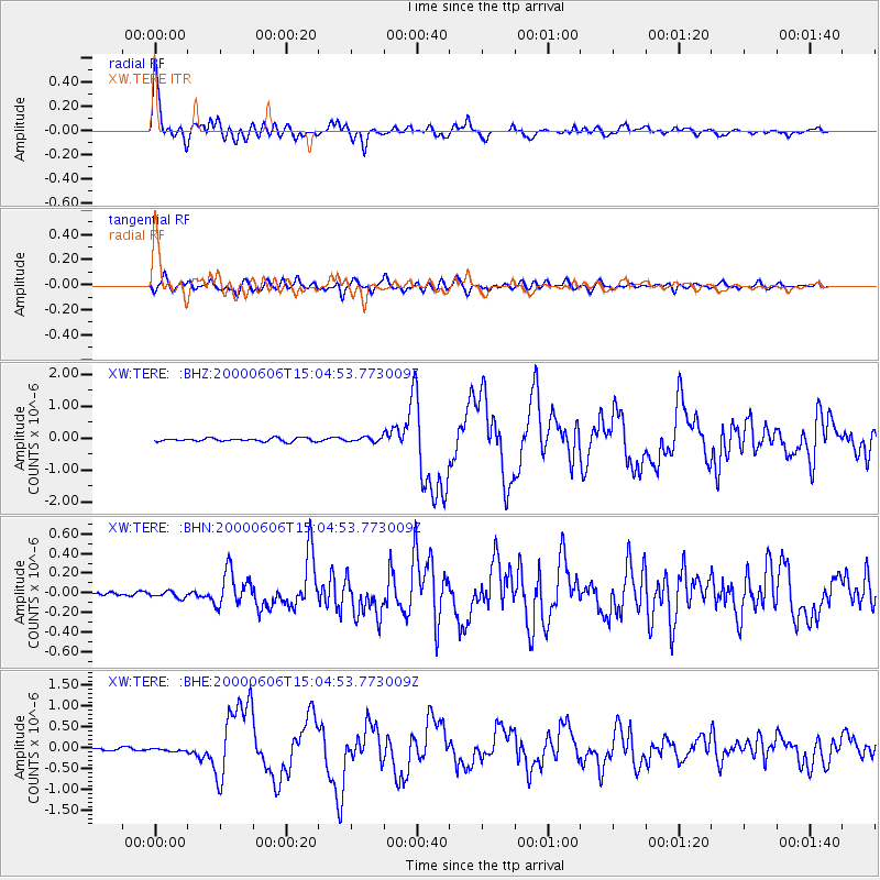
Earthquake location: Southeast Of Ryukyu Islands
Earthquake latitude/longitude: 29.4/131.4
Earthquake time(UTC): 2000/06/06 (158) 14:57:02 GMT
Earthquake Depth: 33 km
Earthquake Magnitude: 5.8 MB, 6.0 MS, 6.4 MW, 6.4 MW
Earthquake Catalog/Contributor: WHDF/NEIC
Network: XW Tien Shan Continental Dynamics
Station: TERE XW.TERE
Lat/Lon: 40.48 N/75.77 E
Elevation: 3684 m
Distance: 46.2 deg
Az: 299.321 deg
Baz: 85.669 deg
Ray Param: 0.07069965
Estimated Moho Depth: 66.75 km
Estimated Crust Vp/Vs: 1.89
Assumed Crust Vp: 6.491 km/s
Estimated Crust Vs: 3.439 km/s
Estimated Crust Poisson's Ratio: 0.30
Radial Match: 96.09448 %
Radial Bump: 400
Transverse Match: 83.20537 %
Transverse Bump: 400
SOD ConfigId: 3744
Insert Time: 2010-02-26 15:47:38.644 +0000
GWidth: 2.5
Max Bumps: 400
Tol: 0.001

Signal To Noise

ChannelStoNSTALTA
XW:TERE: :BHN:20000606T15:04:53.773009Z1.50329973.3617077E-82.2362194E-8
XW:TERE: :BHE:20000606T15:04:53.773009Z1.1647413.955134E-83.3957196E-8
XW:TERE: :BHZ:20000606T15:04:53.773009Z1.41813837.279157E-85.1328968E-8
Arrivals
Ps9.7 SECOND
PpPs28 SECOND
PsPs/PpSs38 SECOND