You are here: Home > Network List > XW97 - Tien Shan Continental Dynamics Stations List
> Station TGMT XW.TGMT > Earthquake Result Viewer
TGMT XW.TGMT - Earthquake Result Viewer

| Earthquake location: |
Bonin Islands, Japan Region |
| Earthquake latitude/longitude: |
28.9/139.6 |
| Earthquake time(UTC): |
2000/08/06 (219) 07:27:12 GMT |
| Earthquake Depth: |
395 km |
| Earthquake Magnitude: |
6.3 MB, 7.3 MW, 7.3 MW |
| Earthquake Catalog/Contributor: |
WHDF/NEIC |
|
| Network: |
XW Tien Shan Continental Dynamics |
| Station: |
TGMT XW.TGMT |
| Lat/Lon: |
40.00 N/76.14 E |
| Elevation: |
1823 m |
|
| Distance: |
52.5 deg |
| Az: |
299.993 deg |
| Baz: |
81.479 deg |
| Ray Param: |
0.06515352 |
| Estimated Moho Depth: |
16.0 km |
| Estimated Crust Vp/Vs: |
1.65 |
| Assumed Crust Vp: |
6.18 km/s |
| Estimated Crust Vs: |
3.751 km/s |
| Estimated Crust Poisson's Ratio: |
0.21 |
|
| Radial Match: |
91.8115 % |
| Radial Bump: |
400 |
| Transverse Match: |
88.75402 % |
| Transverse Bump: |
400 |
| SOD ConfigId: |
20082 |
| Insert Time: |
2010-02-26 15:47:45.267 +0000 |
| GWidth: |
2.5 |
| Max Bumps: |
400 |
| Tol: |
0.001 |
|
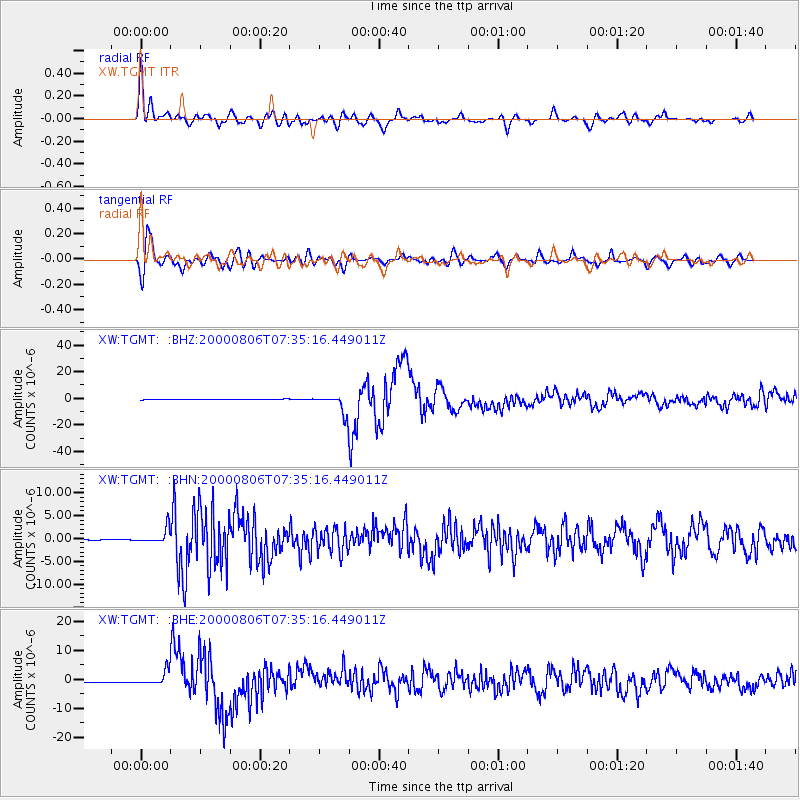
Signal To Noise
| Channel | StoN | STA | LTA |
| XW:TGMT: :BHN:20000806T07:35:16.449011Z | 54.51836 | 1.650154E-6 | 3.0267856E-8 |
| XW:TGMT: :BHE:20000806T07:35:16.449011Z | 11.835709 | 2.3193625E-6 | 1.9596314E-7 |
| XW:TGMT: :BHZ:20000806T07:35:16.449011Z | 31.840641 | 7.2232156E-6 | 2.2685522E-7 |
| Arrivals |
| Ps | 1.8 SECOND |
| PpPs | 6.5 SECOND |
| PsPs/PpSs | 8.3 SECOND |


