
Station XW TGMT - XW.TGMT
Network: XW97 - Tien Shan Continental Dynamics
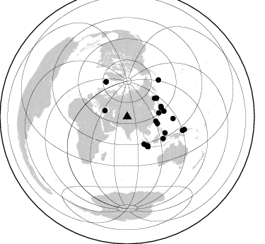
Nearby stations (2 deg radius)
| Station | Name | (Lat, Lon) | Start / End | Elevation |
| TGMT | XW.TGMT | (40.00, 76.14) | 1999-06-19 / 2002-01-01 | 1823 m |
| Crust2 Type: | PJ,orogen/55km, Tibet, 4.5 km seds. |
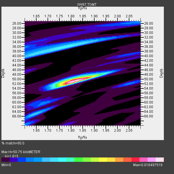
| Thickness Estimate: | 51 km |
| Thickness StdDev: | 0.5 km |
| Vp/Vs Estimate: | 1.82 |
| Vp/Vs StdDev: | 0.02 |
| Vs Estimate: | 3.405 km/s |
| Poisson's Ratio: | 0.28 |
| Peak Value: | 0.02 |
| Assumed Vp: | 6.18 km/s |
| Ps Weight: | 0.33333334 |
| PpPs Weight: | 0.33333334 |
| PsPs Weight: | 0.33333328 |
| Residual Complexity: | 0.588 |
| Nearby stations H: | +- |
| (2.0 deg) Vp/Vs: | +- |
13 with match > 90% ( 52.0 %) and 25 with match > 80% ( 100.0 %) out of 25.
Download stack as xyz text file.
Azimuth Distribution of Events:
Prior Results for this Station
| Study | Thickness | Vp/Vs | Vp | Vs | Poissons Ratio | Extra |
| EARS | 51 km | 1.82 | 6.18 km/s | 3.405 km/s | 0.28 | |
| Crust2.0 | 55 km | 1.77 | 6.18 km/s | 3.496 km/s | 0.26 | PJ,orogen/55km, Tibet, 4.5 km seds. |
| Global Maxima | 51 km | 1.82 | 6.18 km/s | 3.405 km/s | 0.28 | amp=0.016497519 |
| Local Maxima 1 | 50 km | 1.82 | 6.18 km/s | 3.405 km/s | 0.28 | amp=0.0060502384 |
| Local Maxima 2 | 36 km | 1.78 | 6.18 km/s | 3.477 km/s | 0.27 | amp=0.005997187 |
| Local Maxima 3 | 40 km | 1.63 | 6.18 km/s | 3.791 km/s | 0.20 | amp=0.0043767253 |
| Local Maxima 4 | 65 km | 1.65 | 6.18 km/s | 3.74 km/s | 0.21 | amp=0.00397524 |
| Predicted Arrivals for vertical incidence (zero ray parameter) | |
| Ps | 6.69 SECOND |
| PpPs | 23.12 SECOND |
| PsPs/PpSs | 29.81 SECOND |
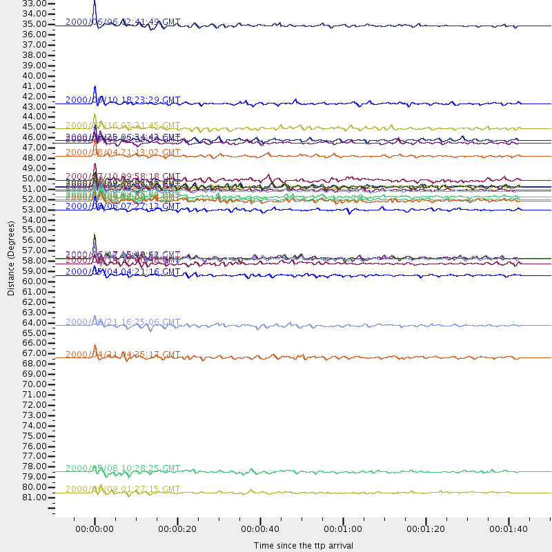
Events Processed for this Station
Download zip of receiver functions as SAC
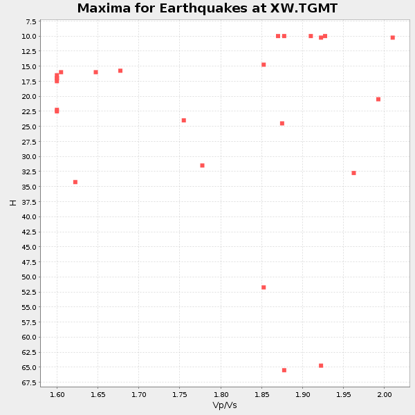
Plot maxima for each earthquake.
Events Used in the Stack
(25 events)| Radial Match | Distance | Baz | FERegion | Time | Lat/Lon | Depth | Magnitude |
| 97.536194 | 50.5 deg | 145.585 deg | Southern Sumatra, Indonesia | 2000/06/04 16:28:26 GMT | (-4.7, 102.1) | 33 km | 6.8 MB, 8.0 MS, 7.9 MW, 7.7 MW |
| 95.54577 | 46.7 deg | 56.207 deg | Sakhalin, Russia | 2000/08/04 21:13:02 GMT | (48.8, 142.2) | 10 km | 6.3 MB, 7.1 MS, 6.8 MW, 6.7 MW |
| 95.32491 | 50.3 deg | 145.736 deg | Southern Sumatra, Indonesia | 2000/06/07 23:45:26 GMT | (-4.6, 101.9) | 33 km | 6.1 MB, 6.7 MS, 6.7 MW, 6.5 MW |
| 93.60323 | 82.9 deg | 102.685 deg | New Britain Region, P.N.G. | 2000/06/09 01:27:15 GMT | (-5.1, 152.5) | 33 km | 5.4 MB, 6.3 MS, 6.3 MW, 6.3 MW |
| 93.35598 | 50.0 deg | 144.886 deg | Southern Sumatra, Indonesia | 2000/07/22 20:56:12 GMT | (-4.1, 102.4) | 69 km | 5.8 MB, 5.8 MW, 5.7 MW |
| 93.15186 | 59.5 deg | 121.298 deg | Sulawesi, Indonesia | 2000/05/04 04:21:16 GMT | (-1.1, 123.6) | 26 km | 6.7 MB, 7.5 MS, 7.6 MW, 7.5 ME |
| 92.94027 | 49.3 deg | 57.892 deg | Sea Of Okhotsk | 2000/07/10 09:58:18 GMT | (46.8, 145.4) | 360 km | 6.1 MB, 5.9 MW, 5.8 MW |
| 92.850426 | 45.3 deg | 148.412 deg | Southwest Of Sumatra, Indonesia | 2000/05/08 12:29:59 GMT | (-0.8, 98.0) | 33 km | 5.6 MB, 5.3 MS, 5.9 MW, 5.6 MW |
| 92.72262 | 51.4 deg | 145.263 deg | Southern Sumatra, Indonesia | 2000/07/08 04:52:55 GMT | (-5.4, 102.7) | 33 km | 5.7 MB, 5.7 MS, 5.9 MW, 5.8 MW |
| 91.85762 | 43.8 deg | 102.858 deg | Philippine Islands Region | 2000/07/16 03:21:45 GMT | (20.3, 122.0) | 33 km | 6.1 MB, 6.3 MS, 6.4 MW, 6.4 MW |
| 91.8115 | 52.5 deg | 81.479 deg | Bonin Islands, Japan Region | 2000/08/06 07:27:12 GMT | (28.9, 139.6) | 395 km | 6.3 MB, 7.3 MW, 7.3 MW |
| 90.63014 | 51.5 deg | 145.365 deg | Southern Sumatra, Indonesia | 2000/06/09 08:00:24 GMT | (-5.5, 102.7) | 33 km | 5.8 MB, 5.8 MS, 6.0 MW, 6.0 MW |
| 90.19082 | 51.1 deg | 145.087 deg | Southern Sumatra, Indonesia | 2000/06/06 09:58:06 GMT | (-5.1, 102.7) | 33 km | 5.8 MB, 6.1 MS, 6.2 MW, 6.1 MW |
| 89.818275 | 45.0 deg | 83.374 deg | Kyushu, Japan | 2000/06/25 06:34:42 GMT | (31.2, 131.2) | 10 km | 5.8 MB, 5.7 MS, 6.2 MW, 5.9 MW |
| 87.925674 | 64.9 deg | 92.421 deg | Mariana Islands | 2000/06/21 16:25:06 GMT | (14.1, 145.0) | 112 km | 5.7 MB, 6.0 MW, 5.9 MW |
| 87.53761 | 57.7 deg | 328.812 deg | Iceland | 2000/06/21 00:51:46 GMT | (64.0, -20.8) | 10 km | 6.1 MB, 6.6 MS, 6.5 MW, 6.4 MW |
| 87.53486 | 58.2 deg | 113.285 deg | Talaud Islands, Indonesia | 2000/06/14 17:00:48 GMT | (4.5, 127.7) | 90 km | 6.1 MB, 5.6 MS, 6.4 MW, 6.3 MW |
| 87.508224 | 50.0 deg | 75.886 deg | Southeast Of Honshu, Japan | 2000/07/30 12:25:45 GMT | (33.9, 139.4) | 10 km | 6.0 MB, 6.5 MS, 6.5 MW, 6.5 MW |
| 86.2574 | 41.1 deg | 99.205 deg | Taiwan | 2000/06/10 18:23:29 GMT | (23.8, 121.2) | 33 km | 6.2 MB, 6.2 MS, 6.4 MW, 6.3 MW |
| 85.64107 | 57.7 deg | 328.768 deg | Iceland | 2000/06/17 15:42:52 GMT | (64.0, -20.6) | 10 km | 5.7 MB |
| 84.89226 | 32.7 deg | 285.457 deg | Turkey | 2000/06/06 02:41:49 GMT | (40.7, 33.0) | 10 km | 5.5 MB, 6.1 MS, 6.1 MW, 6.0 MW |
| 82.870224 | 57.6 deg | 328.736 deg | Iceland | 2000/06/17 15:40:41 GMT | (64.0, -20.5) | 10 km | 5.7 MB, 6.6 MS, 6.8 MW, 6.5 MW |
| 82.846214 | 80.6 deg | 103.881 deg | New Britain Region, P.N.G. | 2000/05/08 10:28:25 GMT | (-4.5, 150.0) | 502 km | 5.7 MB, 6.1 MW, 6.1 MW |
| 81.946075 | 50.1 deg | 73.442 deg | Near East Coast Of Honshu, Japan | 2000/06/03 08:54:49 GMT | (35.6, 140.5) | 62 km | 5.6 MB, 5.6 MS, 6.1 MW, 6.1 MW |
| 81.15647 | 68.4 deg | 40.422 deg | Andreanof Islands, Aleutian Is. | 2000/04/21 04:35:17 GMT | (51.4, -178.1) | 33 km | 6.0 MB, 5.7 MS, 6.2 ML, 6.0 MW |
Losers
(0 events)| Radial Match | Distance | Baz | FERegion | Time | Lat/Lon | Depth | Magnitude | Reason |
