You are here: Home > Network List > XW97 - Tien Shan Continental Dynamics Stations List
> Station TGMT XW.TGMT > Earthquake Result Viewer
TGMT XW.TGMT - Earthquake Result Viewer
| Earthquake location: |
Southern Sumatra, Indonesia |
| Earthquake latitude/longitude: |
-4.1/102.4 |
| Earthquake time(UTC): |
2000/07/22 (204) 20:56:12 GMT |
| Earthquake Depth: |
69 km |
| Earthquake Magnitude: |
5.8 MB, 5.8 MW, 5.7 MW |
| Earthquake Catalog/Contributor: |
WHDF/NEIC |
|
| Network: |
XW Tien Shan Continental Dynamics |
| Station: |
TGMT XW.TGMT |
| Lat/Lon: |
40.00 N/76.14 E |
| Elevation: |
1823 m |
|
| Distance: |
50.0 deg |
| Az: |
333.706 deg |
| Baz: |
144.886 deg |
| Ray Param: |
0.068115994 |
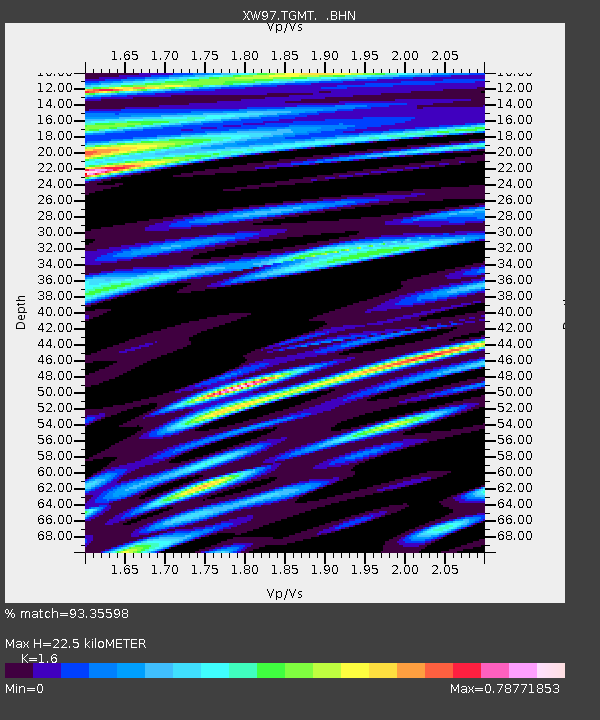
| Estimated Moho Depth: |
22.5 km |
| Estimated Crust Vp/Vs: |
1.60 |
| Assumed Crust Vp: |
6.18 km/s |
| Estimated Crust Vs: |
3.862 km/s |
| Estimated Crust Poisson's Ratio: |
0.18 |
|
| Radial Match: |
93.35598 % |
| Radial Bump: |
400 |
| Transverse Match: |
91.29523 % |
| Transverse Bump: |
400 |
| SOD ConfigId: |
20082 |
| Insert Time: |
2010-02-26 15:47:49.810 +0000 |
| GWidth: |
2.5 |
| Max Bumps: |
400 |
| Tol: |
0.001 |
|

Signal To Noise
| Channel | StoN | STA | LTA |
| XW:TGMT: :BHN:20000722T21:04:29.251003Z | 15.846418 | 4.9000465E-7 | 3.092211E-8 |
| XW:TGMT: :BHE:20000722T21:04:29.251003Z | 8.069309 | 3.4716274E-7 | 4.302261E-8 |
| XW:TGMT: :BHZ:20000722T21:04:29.251003Z | 28.094032 | 1.3211297E-6 | 4.7025278E-8 |
| Arrivals |
| Ps | 2.3 SECOND |
| PpPs | 8.9 SECOND |
| PsPs/PpSs | 11 SECOND |


