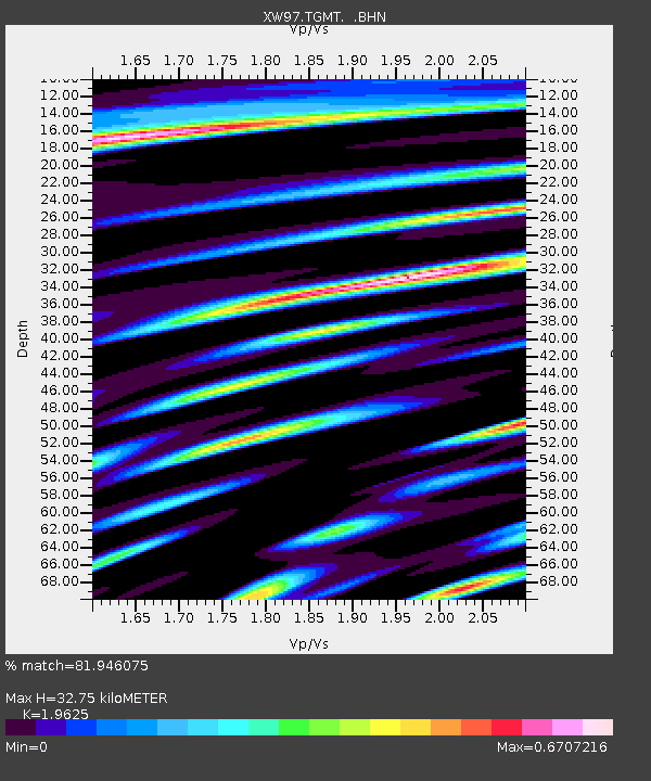
TGMT XW.TGMT - Earthquake Result Viewer

Earthquake location: Near East Coast Of Honshu, Japan
Earthquake latitude/longitude: 35.6/140.5
Earthquake time(UTC): 2000/06/03 (155) 08:54:49 GMT
Earthquake Depth: 62 km
Earthquake Magnitude: 5.6 MB, 5.6 MS, 6.1 MW, 6.1 MW
Earthquake Catalog/Contributor: WHDF/NEIC
Network: XW Tien Shan Continental Dynamics
Station: TGMT XW.TGMT
Lat/Lon: 40.00 N/76.14 E
Elevation: 1823 m
Distance: 50.1 deg
Az: 295.441 deg
Baz: 73.442 deg
Ray Param: 0.068130225
Estimated Moho Depth: 32.75 km
Estimated Crust Vp/Vs: 1.96
Assumed Crust Vp: 6.18 km/s
Estimated Crust Vs: 3.149 km/s
Estimated Crust Poisson's Ratio: 0.32
Radial Match: 81.946075 %
Radial Bump: 400
Transverse Match: 87.624214 %
Transverse Bump: 400
SOD ConfigId: 20082
Insert Time: 2010-02-26 15:48:16.912 +0000
GWidth: 2.5
Max Bumps: 400
Tol: 0.001

Signal To Noise

ChannelStoNSTALTA
XW:TGMT: :BHN:20000603T09:03:07.124011Z7.2302522.660525E-73.6797125E-8
XW:TGMT: :BHE:20000603T09:03:07.124011Z11.1362593.5322392E-73.1718365E-8
XW:TGMT: :BHZ:20000603T09:03:07.124011Z16.4161281.0164624E-66.191852E-8
Arrivals
Ps5.4 SECOND
PpPs15 SECOND
PsPs/PpSs20 SECOND