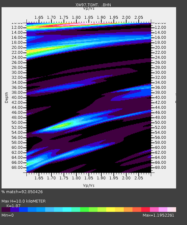
TGMT XW.TGMT - Earthquake Result Viewer
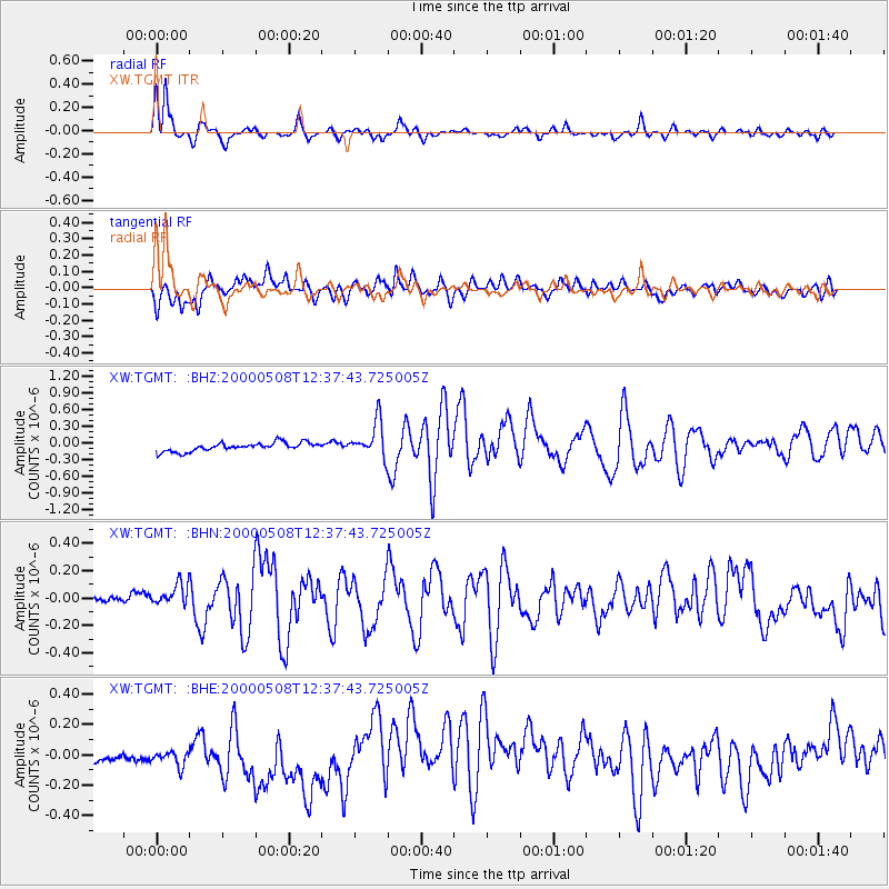
Earthquake location: Southwest Of Sumatra, Indonesia
Earthquake latitude/longitude: -0.8/98.0
Earthquake time(UTC): 2000/05/08 (129) 12:29:59 GMT
Earthquake Depth: 33 km
Earthquake Magnitude: 5.6 MB, 5.3 MS, 5.9 MW, 5.6 MW
Earthquake Catalog/Contributor: WHDF/NEIC
Network: XW Tien Shan Continental Dynamics
Station: TGMT XW.TGMT
Lat/Lon: 40.00 N/76.14 E
Elevation: 1823 m
Distance: 45.3 deg
Az: 336.269 deg
Baz: 148.412 deg
Ray Param: 0.07130834
Estimated Moho Depth: 10.0 km
Estimated Crust Vp/Vs: 1.87
Assumed Crust Vp: 6.18 km/s
Estimated Crust Vs: 3.305 km/s
Estimated Crust Poisson's Ratio: 0.30
Radial Match: 92.850426 %
Radial Bump: 349
Transverse Match: 77.2521 %
Transverse Bump: 400
SOD ConfigId: 20082
Insert Time: 2010-02-26 15:48:18.456 +0000
GWidth: 2.5
Max Bumps: 400
Tol: 0.001

Signal To Noise

ChannelStoNSTALTA
XW:TGMT: :BHN:20000508T12:37:43.725005Z2.6224779.6058415E-83.6628887E-8
XW:TGMT: :BHE:20000508T12:37:43.725005Z0.98992687.966083E-88.047143E-8
XW:TGMT: :BHZ:20000508T12:37:43.725005Z4.15887643.250218E-77.815135E-8
Arrivals
Ps1.5 SECOND
PpPs4.4 SECOND
PsPs/PpSs5.9 SECOND