TGMT XW.TGMT - Earthquake Result Viewer
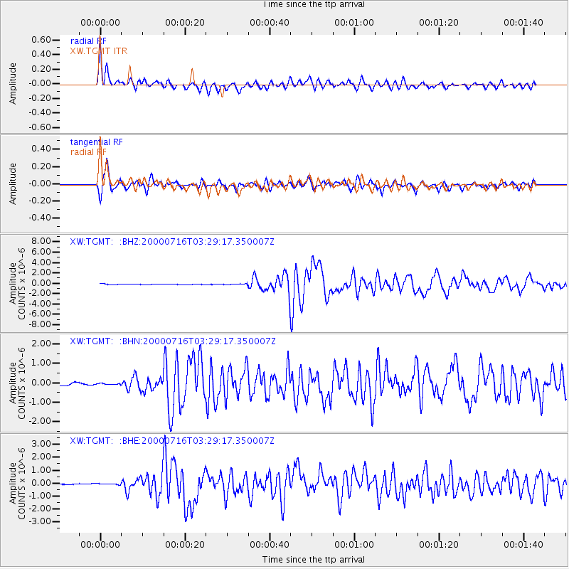
Earthquake location: Philippine Islands Region
Earthquake latitude/longitude: 20.3/122.0
Earthquake time(UTC): 2000/07/16 (198) 03:21:45 GMT
Earthquake Depth: 33 km
Earthquake Magnitude: 6.1 MB, 6.3 MS, 6.4 MW, 6.4 MW
Earthquake Catalog/Contributor: WHDF/NEIC
Network: XW Tien Shan Continental Dynamics
Station: TGMT XW.TGMT
Lat/Lon: 40.00 N/76.14 E
Elevation: 1823 m
Distance: 43.8 deg
Az: 307.092 deg
Baz: 102.858 deg
Ray Param: 0.072273806
Estimated Moho Depth: 17.0 km
Estimated Crust Vp/Vs: 1.60
Assumed Crust Vp: 6.18 km/s
Estimated Crust Vs: 3.862 km/s
Estimated Crust Poisson's Ratio: 0.18
Radial Match: 91.85762 %
Radial Bump: 400
Transverse Match: 88.06462 %
Transverse Bump: 400
SOD ConfigId: 3744
Insert Time: 2010-02-26 15:48:25.437 +0000
GWidth: 2.5
Max Bumps: 400
Tol: 0.001

Signal To Noise

ChannelStoNSTALTA
XW:TGMT: :BHN:20000716T03:29:17.350007Z0.62931254.1810384E-86.643819E-8
XW:TGMT: :BHE:20000716T03:29:17.350007Z0.84571137.418336E-88.7717126E-8
XW:TGMT: :BHZ:20000716T03:29:17.350007Z1.41979448.730962E-86.149455E-8
Arrivals
Ps1.8 SECOND
PpPs6.7 SECOND
PsPs/PpSs8.5 SECOND