You are here: Home > Network List > XY97 - Northern Baja Transect Stations List
> Station LOQI Los Quintos > Earthquake Result Viewer
LOQI Los Quintos - Earthquake Result Viewer
| Earthquake location: |
Northern Peru |
| Earthquake latitude/longitude: |
-4.4/-76.7 |
| Earthquake time(UTC): |
1997/10/28 (301) 06:15:17 GMT |
| Earthquake Depth: |
112 km |
| Earthquake Magnitude: |
6.6 MB, 6.3 MS, 7.2 UNKNOWN, 6.6 ME |
| Earthquake Catalog/Contributor: |
WHDF/NEIC |
|
| Network: |
XY Northern Baja Transect |
| Station: |
LOQI Los Quintos |
| Lat/Lon: |
30.95 N/115.90 W |
| Elevation: |
206 m |
|
| Distance: |
51.3 deg |
| Az: |
315.904 deg |
| Baz: |
126.133 deg |
| Ray Param: |
0.0671202 |
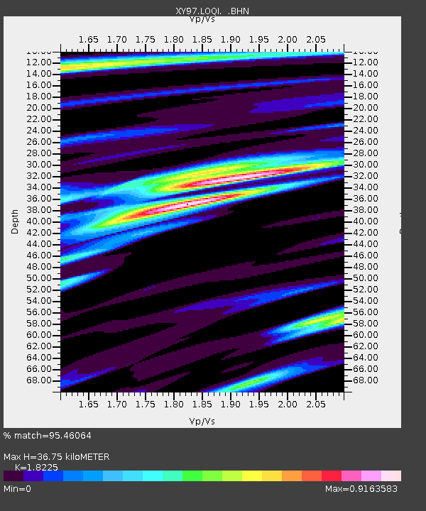
| Estimated Moho Depth: |
36.75 km |
| Estimated Crust Vp/Vs: |
1.82 |
| Assumed Crust Vp: |
6.276 km/s |
| Estimated Crust Vs: |
3.444 km/s |
| Estimated Crust Poisson's Ratio: |
0.28 |
|
| Radial Match: |
95.46064 % |
| Radial Bump: |
328 |
| Transverse Match: |
88.98337 % |
| Transverse Bump: |
400 |
| SOD ConfigId: |
6273 |
| Insert Time: |
2010-03-09 10:50:20.777 +0000 |
| GWidth: |
2.5 |
| Max Bumps: |
400 |
| Tol: |
0.001 |
|

Signal To Noise
| Channel | StoN | STA | LTA |
| XY:LOQI: :BHN:19971028T06:23:39.573987Z | 6.49486 | 3.6903833E-7 | 5.6820056E-8 |
| XY:LOQI: :BHE:19971028T06:23:39.573987Z | 6.665024 | 3.5289355E-7 | 5.294708E-8 |
| XY:LOQI: :BHZ:19971028T06:23:39.573987Z | 8.199184 | 8.5797666E-7 | 1.04641714E-7 |
| Arrivals |
| Ps | 5.1 SECOND |
| PpPs | 16 SECOND |
| PsPs/PpSs | 21 SECOND |


