
Station XY LOQI - Los Quintos
Network: XY97 - Northern Baja Transect
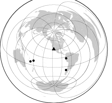
Nearby stations (2 deg radius)
| Station | Name | (Lat, Lon) | Start / End | Elevation |
| LOQI | Los Quintos | (30.95, -115.90) | 1997-10-17 / 2499-01-01 | 206 m |
| Crust2 Type: | M5,extended crust, 0.5 km seds. |
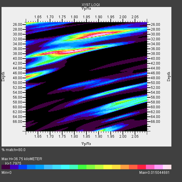
| Thickness Estimate: | 37 km |
| Thickness StdDev: | 9.2 km |
| Vp/Vs Estimate: | 1.80 |
| Vp/Vs StdDev: | 0.13 |
| Vs Estimate: | 3.491 km/s |
| Poisson's Ratio: | 0.28 |
| Peak Value: | 0.02 |
| Assumed Vp: | 6.276 km/s |
| Ps Weight: | 0.33333334 |
| PpPs Weight: | 0.33333334 |
| PsPs Weight: | 0.33333328 |
| Residual Complexity: | 0.785 |
| Nearby stations H: | +- |
| (2.0 deg) Vp/Vs: | +- |
2 with match > 90% ( 13.333333 %) and 4 with match > 80% ( 26.666666 %) out of 15.
Download stack as xyz text file.
Azimuth Distribution of Events:
Prior Results for this Station
| Study | Thickness | Vp/Vs | Vp | Vs | Poissons Ratio | Extra |
| EARS | 37 km | 1.80 | 6.276 km/s | 3.491 km/s | 0.28 | |
| Crust2.0 | 31 km | 1.78 | 6.276 km/s | 3.529 km/s | 0.27 | M5,extended crust, 0.5 km seds. |
| Global Maxima | 37 km | 1.80 | 6.276 km/s | 3.491 km/s | 0.28 | amp=0.015044681 |
| Local Maxima 1 | 30 km | 1.92 | 6.276 km/s | 3.269 km/s | 0.31 | amp=0.013319997 |
| Local Maxima 2 | 70 km | 1.90 | 6.276 km/s | 3.303 km/s | 0.31 | amp=0.010540612 |
| Local Maxima 3 | 48 km | 1.61 | 6.276 km/s | 3.898 km/s | 0.19 | amp=0.009951275 |
| Local Maxima 4 | 58 km | 1.99 | 6.276 km/s | 3.154 km/s | 0.33 | amp=0.0092775915 |
| Predicted Arrivals for vertical incidence (zero ray parameter) | |
| Ps | 4.67 SECOND |
| PpPs | 16.38 SECOND |
| PsPs/PpSs | 21.05 SECOND |
Events Processed for this Station
Download zip of receiver functions as SAC
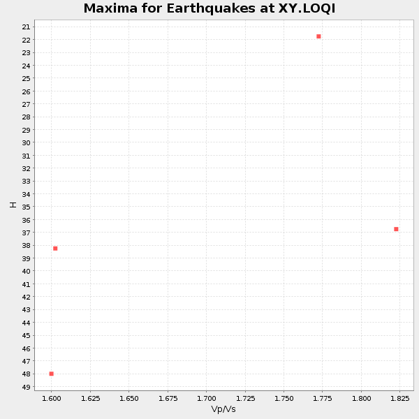
Plot maxima for each earthquake.
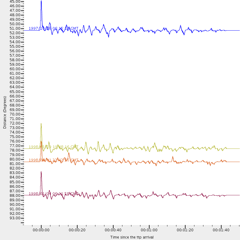
Events Used in the Stack
(4 events)| Radial Match | Distance | Baz | FERegion | Time | Lat/Lon | Depth | Magnitude |
| 95.46064 | 51.3 deg | 126.133 deg | Northern Peru | 1997/10/28 06:15:17 GMT | (-4.4, -76.7) | 112 km | 6.6 MB, 6.3 MS, 7.2 UNKNOWN, 6.6 ME |
| 93.72087 | 87.9 deg | 242.512 deg | Southeast Of Loyalty Islands | 1998/01/04 06:11:58 GMT | (-22.3, 170.9) | 101 km | 6.4 MB, 7.4 UNKNOWN, 7.3 ME |
| 85.407036 | 80.5 deg | 149.405 deg | Off Coast Of Southern Chile | 1998/04/01 22:42:56 GMT | (-40.3, -74.9) | 9.0 km | 6.2 MB, 6.0 MS, 6.7 UNKNOWN, 6.6 ME |
| 83.02326 | 77.5 deg | 240.705 deg | Fiji Islands Region | 1998/03/29 19:48:16 GMT | (-17.6, -179.1) | 537 km | 6.5 MB, 7.2 UNKNOWN, 7.1 MW |
Losers
(11 events)| Radial Match | Distance | Baz | FERegion | Time | Lat/Lon | Depth | Magnitude | Reason |
| 79.676865 | 87.7 deg | 296.458 deg | Volcano Islands, Japan Region | 1998/01/01 06:11:22 GMT | (23.9, 141.9) | 96 km | 6.4 MB, 5.8 MS, 6.8 UNKNOWN, 6.4 MW | |
| 76.33582 | 84.8 deg | 303.241 deg | Southeast Of Honshu, Japan | 1997/11/10 23:06:44 GMT | (31.2, 140.5) | 86 km | 5.8 MB, 6.1 UNKNOWN, 6.1 MW | |
| 73.71063 | 74.7 deg | 141.388 deg | Near Coast Of Central Chile | 1998/01/12 10:14:07 GMT | (-31.0, -71.4) | 35 km | 5.8 MB, 6.2 MS, 6.6 UNKNOWN, 6.2 ME | |
| 70.418304 | 63.4 deg | 127.238 deg | Peru-Bolivia Border Region | 1997/11/28 22:53:41 GMT | (-13.7, -68.8) | 586 km | 6.4 MB, 6.6 UNKNOWN, 6.6 MW | |
| 70.01368 | 74.6 deg | 141.103 deg | Near Coast Of Central Chile | 1997/11/03 19:17:33 GMT | (-30.7, -71.2) | 45 km | 6.2 MB, 5.6 MS, 6.3 UNKNOWN, 5.8 MD | |
| 64.705086 | 68.4 deg | 131.821 deg | Chile-Bolivia Border Region | 1997/12/09 14:23:45 GMT | (-20.2, -68.4) | 133 km | 5.7 MB, 5.7 UNKNOWN, 5.7 MW | |
| 64.122345 | 90.4 deg | 287.338 deg | Mariana Islands | 1997/12/18 20:23:02 GMT | (14.7, 144.7) | 33 km | 5.5 MB, 5.4 MS, 5.9 UNKNOWN, 5.8 MW | |
| 64.07322 | 79.7 deg | 238.011 deg | Fiji Islands Region | 1997/11/04 10:40:43 GMT | (-21.0, -179.2) | 621 km | 5.7 UNKNOWN, 5.1 MB | |
| 51.340107 | 80.5 deg | 310.124 deg | Eastern Honshu, Japan | 1997/10/26 19:06:44 GMT | (39.3, 140.5) | 134 km | 5.6 UNKNOWN, 5.2 MB | |
| 47.470333 | 30.2 deg | 118.229 deg | El Salvador | 1997/12/18 15:02:00 GMT | (13.8, -88.7) | 182 km | 5.3 MB, 6.1 UNKNOWN, 6.0 MW | |
| 41.75062 | 61.4 deg | 318.078 deg | Off East Coast Of Kamchatka | 1997/12/05 11:35:19 GMT | (53.9, 161.6) | 33 km | 5.7 MB |
