You are here: Home > Network List > XY97 - Northern Baja Transect Stations List
> Station LOQI Los Quintos > Earthquake Result Viewer
LOQI Los Quintos - Earthquake Result Viewer
| Earthquake location: |
Fiji Islands Region |
| Earthquake latitude/longitude: |
-17.6/-179.1 |
| Earthquake time(UTC): |
1998/03/29 (088) 19:48:16 GMT |
| Earthquake Depth: |
537 km |
| Earthquake Magnitude: |
6.5 MB, 7.2 UNKNOWN, 7.1 MW |
| Earthquake Catalog/Contributor: |
WHDF/NEIC |
|
| Network: |
XY Northern Baja Transect |
| Station: |
LOQI Los Quintos |
| Lat/Lon: |
30.95 N/115.90 W |
| Elevation: |
206 m |
|
| Distance: |
77.5 deg |
| Az: |
51.753 deg |
| Baz: |
240.705 deg |
| Ray Param: |
0.048617683 |
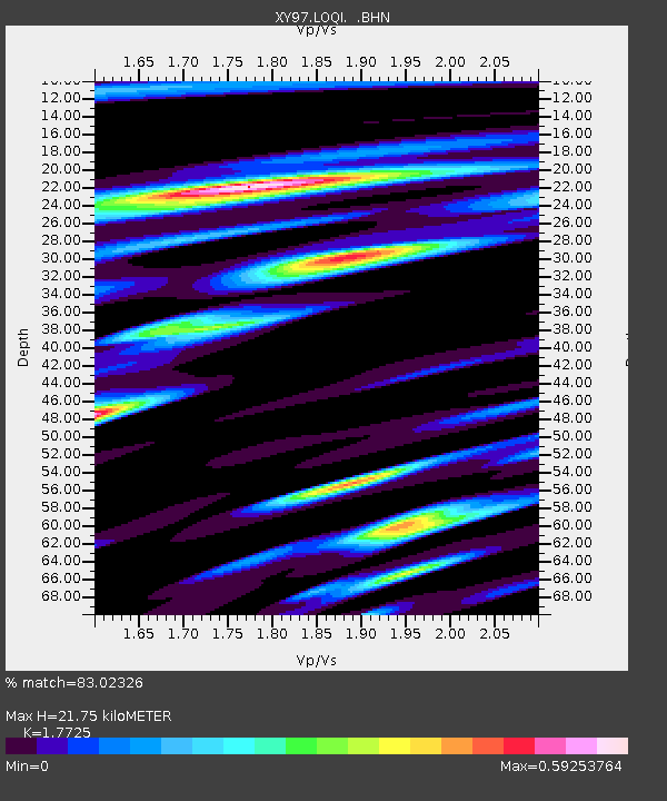
| Estimated Moho Depth: |
21.75 km |
| Estimated Crust Vp/Vs: |
1.77 |
| Assumed Crust Vp: |
6.276 km/s |
| Estimated Crust Vs: |
3.541 km/s |
| Estimated Crust Poisson's Ratio: |
0.27 |
|
| Radial Match: |
83.02326 % |
| Radial Bump: |
383 |
| Transverse Match: |
78.85706 % |
| Transverse Bump: |
400 |
| SOD ConfigId: |
9875 |
| Insert Time: |
2010-03-09 10:50:22.687 +0000 |
| GWidth: |
2.5 |
| Max Bumps: |
400 |
| Tol: |
0.001 |
|

Signal To Noise
| Channel | StoN | STA | LTA |
| XY:LOQI: :BHN:19980329T19:58:45.350024Z | 7.4510427 | 8.356831E-7 | 1.12156535E-7 |
| XY:LOQI: :BHE:19980329T19:58:45.350024Z | 9.954832 | 1.3238683E-6 | 1.3298751E-7 |
| XY:LOQI: :BHZ:19980329T19:58:45.350024Z | 14.863997 | 3.29382E-6 | 2.2159719E-7 |
| Arrivals |
| Ps | 2.8 SECOND |
| PpPs | 9.4 SECOND |
| PsPs/PpSs | 12 SECOND |


