You are here: Home > Network List > IC - New China Digital Seismograph Network Stations List
> Station HIA Hailar, Neimenggu Autonomous Region, China > Earthquake Result Viewer
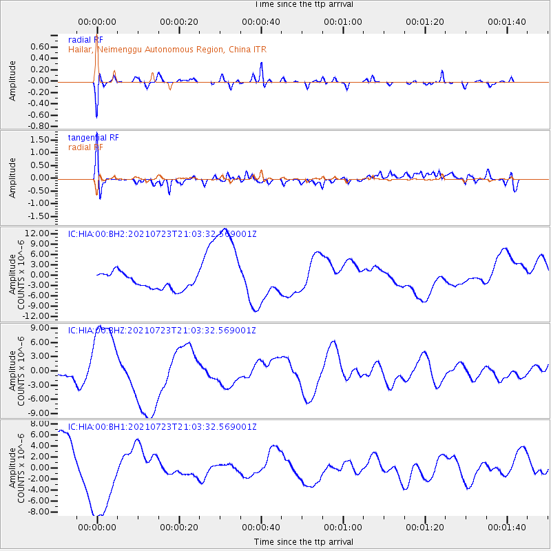
HIA Hailar, Neimenggu Autonomous Region, China - Earthquake Result Viewer
*The percent match for this event was below the threshold and hence no stack was calculated.
| Earthquake location: |
Mindoro, Philippines |
| Earthquake latitude/longitude: |
13.8/120.7 |
| Earthquake time(UTC): |
2021/07/23 (204) 20:57:18 GMT |
| Earthquake Depth: |
122 km |
| Earthquake Magnitude: |
5.8 Mww |
| Earthquake Catalog/Contributor: |
NEIC PDE/us |
|
| Network: |
IC New China Digital Seismograph Network |
| Station: |
HIA Hailar, Neimenggu Autonomous Region, China |
| Lat/Lon: |
49.27 N/119.74 E |
| Elevation: |
620 m |
|
| Distance: |
35.4 deg |
| Az: |
358.878 deg |
| Baz: |
178.335 deg |
| Ray Param: |
$rayparam |
*The percent match for this event was below the threshold and hence was not used in the summary stack. |
|
| Radial Match: |
42.93868 % |
| Radial Bump: |
357 |
| Transverse Match: |
67.792114 % |
| Transverse Bump: |
400 |
| SOD ConfigId: |
25131211 |
| Insert Time: |
2021-08-06 21:13:58.264 +0000 |
| GWidth: |
2.5 |
| Max Bumps: |
400 |
| Tol: |
0.001 |
|
Signal To Noise
| Channel | StoN | STA | LTA |
| IC:HIA:00:BHZ:20210723T21:03:32.569001Z | 7.688789 | 8.804955E-6 | 1.1451679E-6 |
| IC:HIA:00:BH1:20210723T21:03:32.569001Z | 2.841488 | 7.840509E-6 | 2.759297E-6 |
| IC:HIA:00:BH2:20210723T21:03:32.569001Z | 5.811992 | 1.2719047E-5 | 2.1884143E-6 |
| Arrivals |
| Ps | |
| PpPs | |
| PsPs/PpSs | |


