You are here: Home > Network List > XY99 - Nicoya, Costa Rica Stations List
> Station PAPA Golfo Papagayo (Near Playa de Coco) > Earthquake Result Viewer
PAPA Golfo Papagayo (Near Playa de Coco) - Earthquake Result Viewer
| Earthquake location: |
Tonga Islands |
| Earthquake latitude/longitude: |
-15.4/-173.4 |
| Earthquake time(UTC): |
2000/11/09 (314) 05:45:54 GMT |
| Earthquake Depth: |
53 km |
| Earthquake Magnitude: |
5.6 MB, 5.9 MW, 5.7 MW |
| Earthquake Catalog/Contributor: |
WHDF/NEIC |
|
| Network: |
XY Nicoya, Costa Rica |
| Station: |
PAPA Golfo Papagayo (Near Playa de Coco) |
| Lat/Lon: |
10.59 N/85.68 W |
| Elevation: |
38 m |
|
| Distance: |
90.6 deg |
| Az: |
79.261 deg |
| Baz: |
254.525 deg |
| Ray Param: |
0.041651398 |
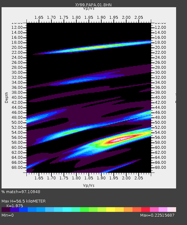
| Estimated Moho Depth: |
56.5 km |
| Estimated Crust Vp/Vs: |
1.98 |
| Assumed Crust Vp: |
6.597 km/s |
| Estimated Crust Vs: |
3.341 km/s |
| Estimated Crust Poisson's Ratio: |
0.33 |
|
| Radial Match: |
97.10948 % |
| Radial Bump: |
147 |
| Transverse Match: |
70.23731 % |
| Transverse Bump: |
400 |
| SOD ConfigId: |
16820 |
| Insert Time: |
2010-03-09 10:52:50.776 +0000 |
| GWidth: |
2.5 |
| Max Bumps: |
400 |
| Tol: |
0.001 |
|

Signal To Noise
| Channel | StoN | STA | LTA |
| XY:PAPA:01:BHN:20001109T05:58:19.521021Z | 1.1693566 | 2.684929E-7 | 2.2960738E-7 |
| XY:PAPA:01:BHE:20001109T05:58:19.521021Z | 0.83107024 | 2.2231275E-7 | 2.6750175E-7 |
| XY:PAPA:01:BHZ:20001109T05:58:19.521021Z | 0.83107024 | 2.2231275E-7 | 2.6750175E-7 |
| Arrivals |
| Ps | 8.5 SECOND |
| PpPs | 25 SECOND |
| PsPs/PpSs | 33 SECOND |


