
Station XY PAPA - Golfo Papagayo (Near Playa de Coco)
Network: XY99 - Nicoya, Costa Rica
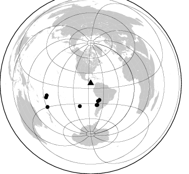
Nearby stations (2 deg radius)

| Station | Name | (Lat, Lon) | Start / End | Elevation |
| PAPA | Golfo Papagayo (Near Playa de Coco) | (10.59, -85.68) | 2000-09-13 / 2001-12-31 | 38 m |
| Crust2 Type: | L3,continental arc, Southern Andes, 0.2 km seds. |
| Thickness Estimate: | 28 km |
| Thickness StdDev: | 17 km |
| Vp/Vs Estimate: | 1.96 |
| Vp/Vs StdDev: | 0.15 |
| Vs Estimate: | 3.37 km/s |
| Poisson's Ratio: | 0.32 |
| Peak Value: | 0.01 |
| Assumed Vp: | 6.597 km/s |
| Ps Weight: | 0.33333334 |
| PpPs Weight: | 0.33333334 |
| PsPs Weight: | 0.33333328 |
| Residual Complexity: | 0.728 |
| Nearby stations H: | +- |
| (2.0 deg) Vp/Vs: | +- |
3 with match > 90% ( 37.5 %) and 8 with match > 80% ( 100.0 %) out of 8.
Download stack as xyz text file.
Azimuth Distribution of Events:
Prior Results for this Station
| Study | Thickness | Vp/Vs | Vp | Vs | Poissons Ratio | Extra |
| EARS | 28 km | 1.96 | 6.597 km/s | 3.37 km/s | 0.32 | |
| Crust2.0 | 40 km | 1.77 | 6.597 km/s | 3.723 km/s | 0.27 | L3,continental arc, Southern Andes, 0.2 km seds. |
| Global Maxima | 28 km | 1.96 | 6.597 km/s | 3.37 km/s | 0.32 | amp=0.005532953 |
| Local Maxima 1 | 55 km | 2.07 | 6.597 km/s | 3.183 km/s | 0.35 | amp=0.0047857477 |
| Local Maxima 2 | 25 km | 1.95 | 6.597 km/s | 3.388 km/s | 0.32 | amp=0.004140083 |
| Local Maxima 3 | 69 km | 1.92 | 6.597 km/s | 3.432 km/s | 0.31 | amp=0.0027880296 |
| Local Maxima 4 | 65 km | 1.64 | 6.597 km/s | 4.029 km/s | 0.20 | amp=0.0027701627 |
| Predicted Arrivals for vertical incidence (zero ray parameter) | |
| Ps | 4.06 SECOND |
| PpPs | 12.55 SECOND |
| PsPs/PpSs | 16.62 SECOND |
Events Processed for this Station
Download zip of receiver functions as SAC
Plot maxima for each earthquake.
Events Used in the Stack
(8 events)| Radial Match | Distance | Baz | FERegion | Time | Lat/Lon | Depth | Magnitude |
| 97.10948 | 90.6 deg | 254.525 deg | Tonga Islands | 2000/11/09 05:45:54 GMT | (-15.4, -173.4) | 53 km | 5.6 MB, 5.9 MW, 5.7 MW |
| 95.718 | 92.9 deg | 252.464 deg | Tonga Islands | 2000/10/31 18:43:20 GMT | (-17.9, -175.3) | 33 km | 5.8 MB, 5.9 MS, 6.1 MW |
| 92.19313 | 44.7 deg | 164.865 deg | Off Coast Of Central Chile | 2001/04/09 09:00:57 GMT | (-32.7, -73.1) | 11 km | 6.1 MB, 6.3 MS, 6.7 MW, 6.3 ME |
| 85.206825 | 37.4 deg | 152.337 deg | Chile-Bolivia Border Region | 2001/06/19 09:32:24 GMT | (-22.7, -67.9) | 147 km | 5.5 MB, 5.2 MS, 6.1 MW, 5.9 MW |
| 84.22437 | 38.1 deg | 157.918 deg | Near Coast Of Northern Chile | 2000/11/29 10:25:13 GMT | (-24.9, -70.9) | 58 km | 5.8 MB, 5.9 MS, 6.4 MW, 6.3 MW |
| 82.761345 | 97.7 deg | 241.295 deg | Kermadec Islands, New Zealand | 2001/06/03 02:41:57 GMT | (-29.7, -178.6) | 178 km | 6.8 MB, 7.2 MW, 7.1 MW |
| 81.993904 | 44.8 deg | 162.868 deg | Near Coast Of Central Chile | 2001/03/15 13:02:42 GMT | (-32.3, -71.5) | 37 km | 6.1 MB, 5.6 MS, 6.0 MW, 5.4 MD |
| 80.58897 | 50.4 deg | 205.571 deg | Southern East Pacific Rise | 2000/10/25 19:00:17 GMT | (-34.7, -109.5) | 10 km | 5.6 MB, 5.7 MS, 6.1 MW, 6.1 MW |
Losers
(0 events)| Radial Match | Distance | Baz | FERegion | Time | Lat/Lon | Depth | Magnitude | Reason |
