You are here: Home > Network List > NN - Western Great Basin/Eastern Sierra Nevada Stations List
> Station OMM Old Mammoth Mine, Mammoth Lakes, CA, USA > Earthquake Result Viewer
OMM Old Mammoth Mine, Mammoth Lakes, CA, USA - Earthquake Result Viewer
| Earthquake location: |
Vanuatu Islands |
| Earthquake latitude/longitude: |
-17.5/167.8 |
| Earthquake time(UTC): |
2005/09/25 (268) 22:58:54 GMT |
| Earthquake Depth: |
30 km |
| Earthquake Magnitude: |
5.2 MB, 5.2 MS, 5.6 MW, 5.6 MW |
| Earthquake Catalog/Contributor: |
WHDF/NEIC |
|
| Network: |
NN Western Great Basin/Eastern Sierra Nevada |
| Station: |
OMM Old Mammoth Mine, Mammoth Lakes, CA, USA |
| Lat/Lon: |
37.62 N/119.00 W |
| Elevation: |
2750 m |
|
| Distance: |
87.9 deg |
| Az: |
49.533 deg |
| Baz: |
246.121 deg |
| Ray Param: |
0.042972513 |
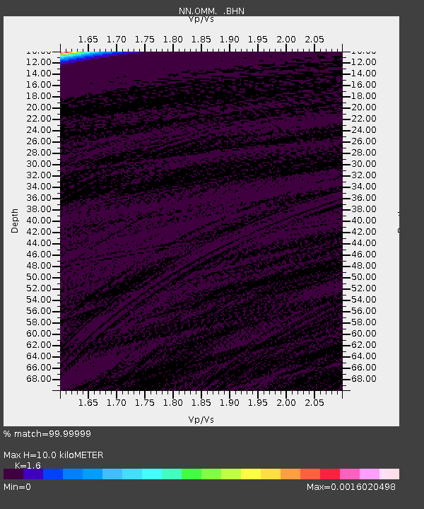
| Estimated Moho Depth: |
10.0 km |
| Estimated Crust Vp/Vs: |
1.60 |
| Assumed Crust Vp: |
6.291 km/s |
| Estimated Crust Vs: |
3.932 km/s |
| Estimated Crust Poisson's Ratio: |
0.18 |
|
| Radial Match: |
99.99999 % |
| Radial Bump: |
2 |
| Transverse Match: |
99.99998 % |
| Transverse Bump: |
2 |
| SOD ConfigId: |
2669 |
| Insert Time: |
2010-03-09 10:58:45.206 +0000 |
| GWidth: |
2.5 |
| Max Bumps: |
400 |
| Tol: |
0.001 |
|

Signal To Noise
| Channel | StoN | STA | LTA |
| NN:OMM: :BHN:20050925T23:11:09.921018Z | 0.89328676 | 4.4062068E-7 | 4.9325786E-7 |
| NN:OMM: :BHE:20050925T23:11:09.921018Z | 0.8976552 | 4.404544E-7 | 4.906721E-7 |
| NN:OMM: :BHZ:20050925T23:11:09.921018Z | 0.89111584 | 4.414349E-7 | 4.9537323E-7 |
| Arrivals |
| Ps | 1.0 SECOND |
| PpPs | 4.0 SECOND |
| PsPs/PpSs | 5.0 SECOND |


