
Station NN OMM - Old Mammoth Mine, Mammoth Lakes, CA, USA
Network: NN - Western Great Basin/Eastern Sierra Nevada
Nearby stations (2 deg radius)
| Station | Name | (Lat, Lon) | Start / End | Elevation |
| OMM | Old Mammoth Mine, Mammoth Lakes, CA, USA | (37.62, -119.00) | 2000-10-01 / 2499-01-01 | 2.8 km |
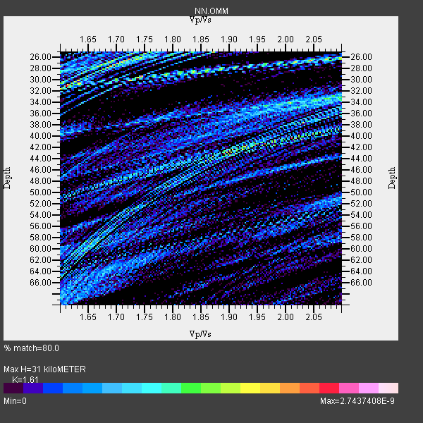
| Crust2 Type: | M9,thick extended crust, 0.5 km seds. |
| Thickness Estimate: | 31 km |
| Thickness StdDev: | 6.2 km |
| Vp/Vs Estimate: | 1.61 |
| Vp/Vs StdDev: | 0.14 |
| Vs Estimate: | 3.908 km/s |
| Poisson's Ratio: | 0.19 |
| Peak Value: | 0.00 |
| Assumed Vp: | 6.291 km/s |
| Ps Weight: | 0.33333334 |
| PpPs Weight: | 0.33333334 |
| PsPs Weight: | 0.33333328 |
| Residual Complexity: | 0.905 |
| Nearby stations H: | +- |
| (2.0 deg) Vp/Vs: | +- |
7 with match > 90% ( 100.0 %) and 7 with match > 80% ( 100.0 %) out of 7.
Download stack as xyz text file.
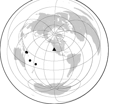
Azimuth Distribution of Events:
Prior Results for this Station
| Study | Thickness | Vp/Vs | Vp | Vs | Poissons Ratio | Extra |
| EARS | 31 km | 1.61 | 6.291 km/s | 3.908 km/s | 0.19 | |
| Crust2.0 | 40 km | 1.78 | 6.291 km/s | 3.539 km/s | 0.27 | M9,thick extended crust, 0.5 km seds. |
| Global Maxima | 31 km | 1.61 | 6.291 km/s | 3.908 km/s | 0.19 | amp=2.7437408E-9 |
| Local Maxima 1 | 42 km | 1.95 | 6.291 km/s | 3.235 km/s | 0.32 | amp=2.307853E-9 |
| Local Maxima 2 | 26 km | 1.72 | 6.291 km/s | 3.668 km/s | 0.24 | amp=2.1084947E-9 |
| Local Maxima 3 | 34 km | 2.01 | 6.291 km/s | 3.134 km/s | 0.33 | amp=1.6901442E-9 |
| Local Maxima 4 | 59 km | 1.66 | 6.291 km/s | 3.779 km/s | 0.22 | amp=1.5695465E-9 |
| Predicted Arrivals for vertical incidence (zero ray parameter) | |
| Ps | 3.01 SECOND |
| PpPs | 12.86 SECOND |
| PsPs/PpSs | 15.87 SECOND |
Events Processed for this Station
Download zip of receiver functions as SAC
Plot maxima for each earthquake.
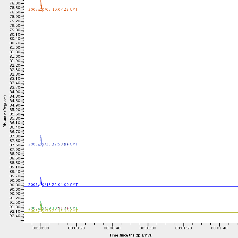
Events Used in the Stack
(7 events)| Radial Match | Distance | Baz | FERegion | Time | Lat/Lon | Depth | Magnitude |
| 99.99999 | 87.9 deg | 246.121 deg | Vanuatu Islands | 2005/09/25 22:58:54 GMT | (-17.5, 167.8) | 30 km | 5.2 MB, 5.2 MS, 5.6 MW, 5.6 MW |
| 99.99999 | 92.7 deg | 265.085 deg | New Britain Region, P.N.G. | 2005/09/29 18:23:25 GMT | (-5.6, 151.9) | 28 km | 5.8 MB, 6.0 MS, 6.2 MW, 6.1 MW |
| 99.99999 | 92.7 deg | 265.188 deg | New Britain Region, P.N.G. | 2005/09/29 18:51:14 GMT | (-5.5, 151.8) | 25 km | 5.6 MB, 5.1 MS, 5.7 MW |
| 99.99999 | 92.9 deg | 265.112 deg | New Britain Region, P.N.G. | 2005/09/30 23:15:19 GMT | (-5.7, 151.7) | 25 km | 5.5 MB, 5.7 MS, 5.9 MW, 5.9 MW |
| 99.99999 | 77.8 deg | 232.02 deg | Tonga Islands | 2005/10/05 10:07:22 GMT | (-20.5, -174.3) | 15 km | 6.0 MB, 5.7 MS, 6.0 MW, 6.0 MW |
| 99.999985 | 90.9 deg | 264.262 deg | New Ireland Region, P.N.G. | 2005/10/13 22:04:09 GMT | (-5.1, 153.8) | 33 km | 5.7 MB, 5.2 MS, 5.7 MW, 5.7 MW |
| 99.99996 | 87.9 deg | 246.081 deg | Vanuatu Islands | 2005/09/25 12:55:46 GMT | (-17.5, 167.8) | 30 km | 5.7 MB, 5.9 MS, 6.2 MW, 6.2 MW |
Losers
(0 events)| Radial Match | Distance | Baz | FERegion | Time | Lat/Lon | Depth | Magnitude | Reason |
