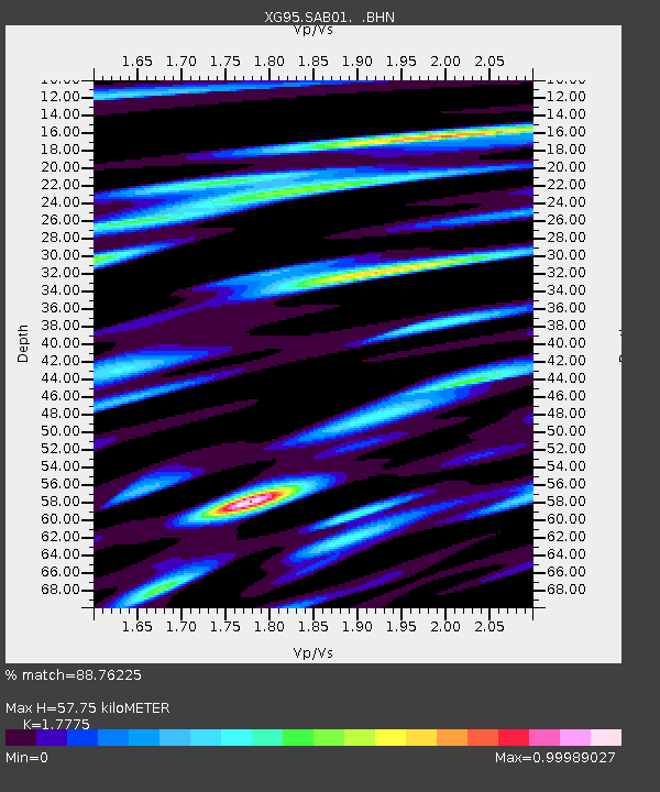
SAB01 Saidu - Earthquake Result Viewer

Earthquake location: Near East Coast Of Honshu, Japan
Earthquake latitude/longitude: 35.5/140.9
Earthquake time(UTC): 1996/09/11 (255) 02:37:14 GMT
Earthquake Depth: 55 km
Earthquake Magnitude: 6.1 MB, 5.7 MS, 6.2 UNKNOWN, 6.1 MW
Earthquake Catalog/Contributor: WHDF/NEIC
Network: XG Nanga Parbat Pakistan
Station: SAB01 Saidu
Lat/Lon: 34.73 N/72.34 E
Elevation: 1002 m
Distance: 55.0 deg
Az: 290.631 deg
Baz: 67.932 deg
Ray Param: 0.06492466
Estimated Moho Depth: 57.75 km
Estimated Crust Vp/Vs: 1.78
Assumed Crust Vp: 6.5 km/s
Estimated Crust Vs: 3.657 km/s
Estimated Crust Poisson's Ratio: 0.27
Radial Match: 88.76225 %
Radial Bump: 400
Transverse Match: 82.83742 %
Transverse Bump: 400
SOD ConfigId: 6273
Insert Time: 2010-03-09 11:06:50.341 +0000
GWidth: 2.5
Max Bumps: 400
Tol: 0.001

Signal To Noise

ChannelStoNSTALTA
XG:SAB01: :BHN:19960911T02:46:10.230994Z2.0315316.353374E-83.1273824E-8
XG:SAB01: :BHE:19960911T02:46:10.230994Z5.45502141.3931164E-72.5538238E-8
XG:SAB01: :BHZ:19960911T02:46:10.230994Z6.91588263.179352E-74.5971742E-8
Arrivals
Ps7.3 SECOND
PpPs23 SECOND
PsPs/PpSs31 SECOND