
Station XG SAB01 - Saidu
Network: XG95 - Nanga Parbat Pakistan
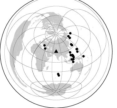
Nearby stations (2 deg radius)
| Station | Name | (Lat, Lon) | Start / End | Elevation |
| SAB01 | Saidu | (34.73, 72.34) | 1996-05-21 / 1996-12-31 | 1002 m |
| Crust2 Type: | RB,orogen/60km Tibet Transition, 0 km seds. |
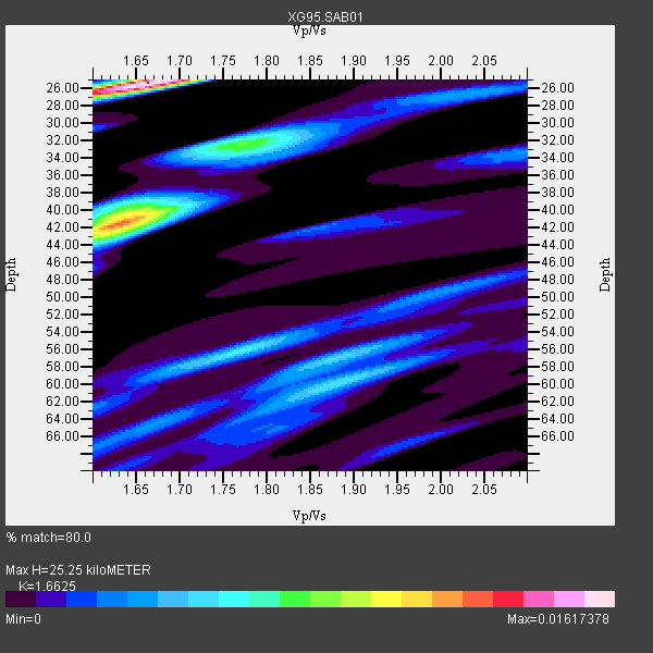
| Thickness Estimate: | 25 km |
| Thickness StdDev: | 9.7 km |
| Vp/Vs Estimate: | 1.66 |
| Vp/Vs StdDev: | 0.06 |
| Vs Estimate: | 3.91 km/s |
| Poisson's Ratio: | 0.22 |
| Peak Value: | 0.02 |
| Assumed Vp: | 6.5 km/s |
| Ps Weight: | 0.33333334 |
| PpPs Weight: | 0.33333334 |
| PsPs Weight: | 0.33333328 |
| Residual Complexity: | 0.862 |
| Nearby stations H: | +- |
| (2.0 deg) Vp/Vs: | +- |
10 with match > 90% ( 28.571428 %) and 28 with match > 80% ( 80.0 %) out of 35.
Download stack as xyz text file.
Azimuth Distribution of Events:
Prior Results for this Station
| Study | Thickness | Vp/Vs | Vp | Vs | Poissons Ratio | Extra |
| EARS | 25 km | 1.66 | 6.5 km/s | 3.91 km/s | 0.22 | |
| Crust2.0 | 60 km | 1.76 | 6.5 km/s | 3.7 km/s | 0.26 | RB,orogen/60km Tibet Transition, 0 km seds. |
| Global Maxima | 25 km | 1.66 | 6.5 km/s | 3.91 km/s | 0.22 | amp=0.01617378 |
| Local Maxima 1 | 42 km | 1.63 | 6.5 km/s | 3.994 km/s | 0.20 | amp=0.012544325 |
| Local Maxima 2 | 32 km | 1.77 | 6.5 km/s | 3.672 km/s | 0.27 | amp=0.007866128 |
| Local Maxima 3 | 40 km | 1.64 | 6.5 km/s | 3.951 km/s | 0.21 | amp=0.0060248543 |
| Local Maxima 4 | 56 km | 1.76 | 6.5 km/s | 3.688 km/s | 0.26 | amp=0.0058572204 |
| Predicted Arrivals for vertical incidence (zero ray parameter) | |
| Ps | 2.57 SECOND |
| PpPs | 10.34 SECOND |
| PsPs/PpSs | 12.92 SECOND |
Events Processed for this Station
Download zip of receiver functions as SAC
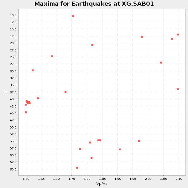
Plot maxima for each earthquake.
Events Used in the Stack
(28 events)| Radial Match | Distance | Baz | FERegion | Time | Lat/Lon | Depth | Magnitude |
| 92.692856 | 54.1 deg | 103.8 deg | Leyte, Philippines | 1996/09/28 14:10:42 GMT | (10.0, 125.4) | 235 km | 5.6 MB, 6.4 UNKNOWN, 6.3 MW |
| 92.54328 | 55.1 deg | 103.584 deg | Mindanao, Philippines | 1996/09/20 00:03:18 GMT | (9.6, 126.3) | 33 km | 5.8 MB, 6.2 MS, 6.4 UNKNOWN, 6.4 MW |
| 92.05013 | 55.2 deg | 103.722 deg | Mindanao, Philippines | 1996/09/20 04:10:27 GMT | (9.5, 126.3) | 33 km | 5.8 MB, 6.4 MS, 6.6 UNKNOWN, 6.6 MW |
| 92.003044 | 36.6 deg | 285.598 deg | Dodecanese Islands, Greece | 1996/07/20 00:00:41 GMT | (36.1, 27.1) | 33 km | 5.7 MB, 6.2 MS, 6.2 UNKNOWN, 6.1 MW |
| 91.75154 | 44.7 deg | 93.18 deg | Taiwan Region | 1996/09/05 23:42:06 GMT | (21.9, 121.5) | 20 km | 6.4 MB, 6.6 MS, 6.8 UNKNOWN, 6.8 ME |
| 91.105034 | 55.4 deg | 103.557 deg | Mindanao, Philippines | 1996/09/20 12:24:42 GMT | (9.4, 126.5) | 33 km | 5.4 MB, 6.0 MS, 6.3 UNKNOWN, 6.0 MW |
| 91.09618 | 67.9 deg | 90.093 deg | South Of Mariana Islands | 1996/09/02 20:41:52 GMT | (12.3, 143.8) | 33 km | 5.7 MB, 5.7 MS, 5.9 UNKNOWN, 5.8 MW |
| 90.940674 | 53.3 deg | 101.627 deg | Samar, Philippines | 1996/08/08 23:12:35 GMT | (12.0, 125.7) | 33 km | 5.5 MS, 5.4 MB |
| 90.61198 | 66.1 deg | 83.196 deg | Mariana Islands | 1996/07/15 16:51:22 GMT | (18.7, 145.6) | 177 km | 5.9 MB, 6.3 UNKNOWN, 6.3 MW |
| 90.219505 | 74.2 deg | 37.861 deg | Andreanof Islands, Aleutian Is. | 1996/08/19 04:19:16 GMT | (51.5, -178.4) | 33 km | 5.7 MB, 5.6 MS, 6.0 UNKNOWN, 5.7 ML |
| 88.975395 | 88.8 deg | 99.633 deg | Solomon Islands | 1996/09/06 17:03:46 GMT | (-7.3, 155.9) | 33 km | 5.6 MB, 6.1 MS, 6.3 UNKNOWN, 6.2 MW |
| 88.76225 | 55.0 deg | 67.932 deg | Near East Coast Of Honshu, Japan | 1996/09/11 02:37:14 GMT | (35.5, 140.9) | 55 km | 6.1 MB, 5.7 MS, 6.2 UNKNOWN, 6.1 MW |
| 88.0759 | 48.2 deg | 103.201 deg | Mindoro, Philippines | 1996/07/20 09:14:04 GMT | (13.9, 120.7) | 110 km | 5.5 MB, 5.9 UNKNOWN, 5.9 MW |
| 87.621864 | 55.8 deg | 116.224 deg | Minahassa Peninsula, Sulawesi | 1996/07/16 10:07:36 GMT | (1.0, 120.3) | 33 km | 6.0 MB, 6.4 MS, 6.6 UNKNOWN, 6.6 MW |
| 87.19284 | 55.2 deg | 103.696 deg | Mindanao, Philippines | 1996/09/20 04:11:04 GMT | (9.5, 126.3) | 33 km | 5.9 MB |
| 86.853165 | 53.6 deg | 64.158 deg | Eastern Honshu, Japan | 1996/08/10 18:12:17 GMT | (38.9, 140.5) | 10 km | 6.0 MB, 5.7 MS, 5.9 UNKNOWN, 5.9 MW |
| 86.44831 | 62.1 deg | 44.974 deg | Off East Coast Of Kamchatka | 1996/07/18 22:55:03 GMT | (51.5, 159.4) | 33 km | 5.5 MB, 5.2 MS |
| 85.533195 | 63.4 deg | 38.785 deg | Komandorskiye Ostrova Region | 1996/07/16 03:48:28 GMT | (56.1, 165.0) | 33 km | 5.8 MB, 6.4 MS, 6.5 UNKNOWN, 6.3 MW |
| 84.83959 | 67.2 deg | 82.786 deg | Mariana Islands | 1996/06/04 23:22:05 GMT | (18.5, 146.9) | 59 km | 5.3 MB, 5.6 MS, 6.0 UNKNOWN, 5.8 MW |
| 84.66678 | 55.4 deg | 103.366 deg | Mindanao, Philippines | 1996/09/20 19:24:57 GMT | (9.6, 126.6) | 33 km | 5.5 MB, 5.6 MS, 5.9 UNKNOWN, 5.8 MW |
| 83.94422 | 71.5 deg | 174.803 deg | Mid-Indian Ridge | 1996/08/27 10:50:49 GMT | (-36.9, 78.5) | 10 km | 5.8 MS, 5.3 MB, 5.9 UNKNOWN, 5.9 MW |
| 83.1112 | 76.2 deg | 173.762 deg | Mid-Indian Ridge | 1996/08/19 06:24:11 GMT | (-41.5, 80.4) | 10 km | 5.4 MB, 5.9 MS, 6.0 UNKNOWN, 5.9 MW |
| 82.98267 | 60.3 deg | 113.553 deg | Southern Molucca Sea | 1996/08/12 17:00:27 GMT | (-0.3, 125.1) | 42 km | 5.7 MB, 5.5 MS, 6.1 UNKNOWN, 6.0 MW |
| 82.43346 | 63.6 deg | 120.624 deg | Banda Sea | 1996/08/22 05:35:42 GMT | (-7.1, 123.3) | 596 km | 5.8 MB, 5.9 UNKNOWN, 5.8 MW |
| 81.50984 | 42.5 deg | 297.734 deg | Adriatic Sea | 1996/09/05 20:44:09 GMT | (42.8, 17.9) | 10 km | 5.6 MB, 6.0 MS, 6.0 UNKNOWN, 5.7 MW |
| 81.25823 | 58.4 deg | 115.095 deg | Minahassa Peninsula, Sulawesi | 1996/09/14 02:53:24 GMT | (-0.0, 122.8) | 181 km | 5.5 MB |
| 80.94839 | 58.8 deg | 107.194 deg | Talaud Islands, Indonesia | 1996/08/13 10:07:08 GMT | (5.0, 127.4) | 75 km | 5.7 UNKNOWN, 5.0 MS, 5.4 MB |
| 80.922 | 55.2 deg | 103.41 deg | Mindanao, Philippines | 1996/09/25 09:26:45 GMT | (9.7, 126.4) | 33 km | 5.5 MB, 5.7 MS |
Losers
(7 events)| Radial Match | Distance | Baz | FERegion | Time | Lat/Lon | Depth | Magnitude | Reason |
| 79.67178 | 57.1 deg | 45.88 deg | Sea Of Okhotsk | 1996/08/30 21:13:41 GMT | (52.3, 151.5) | 580 km | 5.5 UNKNOWN, 5.1 MB, 5.4 MW | |
| 78.555115 | 88.8 deg | 99.637 deg | Solomon Islands | 1996/09/06 12:39:41 GMT | (-7.3, 155.8) | 33 km | 5.5 MB, 5.8 MS, 5.9 UNKNOWN, 5.9 MW | |
| 76.82496 | 81.4 deg | 102.753 deg | Eastern New Guinea Reg., P.N.G. | 1996/05/31 01:31:37 GMT | (-5.5, 148.0) | 243 km | 5.6 UNKNOWN, 5.3 MB | |
| 76.261406 | 44.7 deg | 139.23 deg | Southern Sumatra, Indonesia | 1996/08/09 00:27:05 GMT | (-2.0, 99.7) | 33 km | 5.5 MS, 5.4 MB, 5.8 UNKNOWN, 5.7 MW | |
| 75.60509 | 87.5 deg | 99.586 deg | Solomon Islands | 1996/09/15 18:17:38 GMT | (-6.5, 154.8) | 50 km | 5.7 MB, 5.8 MS, 5.9 UNKNOWN, 5.9 MW | |
| 75.38176 | 48.1 deg | 82.552 deg | Ryukyu Islands, Japan | 1996/06/02 09:37:46 GMT | (27.4, 128.5) | 42 km | 5.8 MB, 5.2 MS, 5.8 UNKNOWN, 5.8 MW | |
| 74.11541 | 88.6 deg | 99.646 deg | Solomon Islands | 1996/09/07 09:06:00 GMT | (-7.2, 155.7) | 10 km | 5.6 MS, 5.4 MB, 5.8 UNKNOWN, 5.7 MW |
