You are here: Home > Network List > XG95 - Nanga Parbat Pakistan Stations List
> Station SAB01 Saidu > Earthquake Result Viewer
SAB01 Saidu - Earthquake Result Viewer
| Earthquake location: |
Southern Molucca Sea |
| Earthquake latitude/longitude: |
-0.3/125.1 |
| Earthquake time(UTC): |
1996/08/12 (225) 17:00:27 GMT |
| Earthquake Depth: |
42 km |
| Earthquake Magnitude: |
5.7 MB, 5.5 MS, 6.1 UNKNOWN, 6.0 MW |
| Earthquake Catalog/Contributor: |
WHDF/NEIC |
|
| Network: |
XG Nanga Parbat Pakistan |
| Station: |
SAB01 Saidu |
| Lat/Lon: |
34.73 N/72.34 E |
| Elevation: |
1002 m |
|
| Distance: |
60.3 deg |
| Az: |
310.974 deg |
| Baz: |
113.553 deg |
| Ray Param: |
0.061553244 |
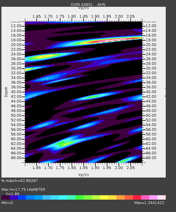
| Estimated Moho Depth: |
17.75 km |
| Estimated Crust Vp/Vs: |
1.98 |
| Assumed Crust Vp: |
6.5 km/s |
| Estimated Crust Vs: |
3.283 km/s |
| Estimated Crust Poisson's Ratio: |
0.33 |
|
| Radial Match: |
82.98267 % |
| Radial Bump: |
400 |
| Transverse Match: |
82.4885 % |
| Transverse Bump: |
400 |
| SOD ConfigId: |
6273 |
| Insert Time: |
2010-03-09 11:07:03.717 +0000 |
| GWidth: |
2.5 |
| Max Bumps: |
400 |
| Tol: |
0.001 |
|

Signal To Noise
| Channel | StoN | STA | LTA |
| XG:SAB01: :BHN:19960812T17:10:01.402014Z | 4.583968 | 1.314745E-7 | 2.8681372E-8 |
| XG:SAB01: :BHE:19960812T17:10:01.402014Z | 3.8876681 | 2.0650201E-7 | 5.311719E-8 |
| XG:SAB01: :BHZ:19960812T17:10:01.402014Z | 5.8715086 | 4.2562837E-7 | 7.249046E-8 |
| Arrivals |
| Ps | 2.8 SECOND |
| PpPs | 7.8 SECOND |
| PsPs/PpSs | 11 SECOND |


