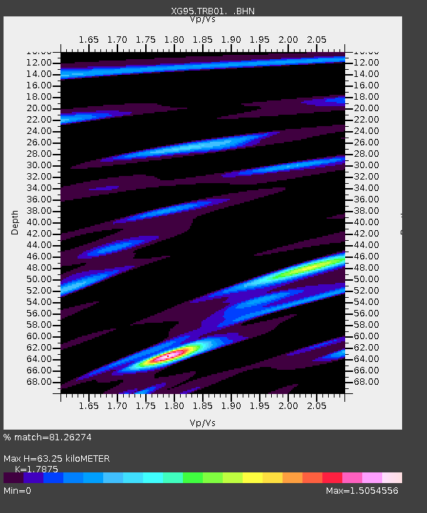
TRB01 Thowar / Rondu - Earthquake Result Viewer

Earthquake location: Samar, Philippines
Earthquake latitude/longitude: 12.8/125.1
Earthquake time(UTC): 1996/06/14 (166) 15:04:40 GMT
Earthquake Depth: 29 km
Earthquake Magnitude: 5.6 MB, 5.8 MS, 6.1 UNKNOWN, 5.9 MW
Earthquake Catalog/Contributor: WHDF/NEIC
Network: XG Nanga Parbat Pakistan
Station: TRB01 Thowar / Rondu
Lat/Lon: 35.60 N/75.22 E
Elevation: 2072 m
Distance: 50.2 deg
Az: 305.815 deg
Baz: 103.942 deg
Ray Param: 0.06818143
Estimated Moho Depth: 63.25 km
Estimated Crust Vp/Vs: 1.79
Assumed Crust Vp: 6.481 km/s
Estimated Crust Vs: 3.626 km/s
Estimated Crust Poisson's Ratio: 0.27
Radial Match: 81.26274 %
Radial Bump: 400
Transverse Match: 59.89276 %
Transverse Bump: 400
SOD ConfigId: 6273
Insert Time: 2010-03-09 11:07:39.491 +0000
GWidth: 2.5
Max Bumps: 400
Tol: 0.001

Signal To Noise

ChannelStoNSTALTA
XG:TRB01: :BHN:19960614T15:13:02.909991Z2.02170542.2908951E-71.1331498E-7
XG:TRB01: :BHE:19960614T15:13:02.909991Z1.57575381.5008858E-79.524875E-8
XG:TRB01: :BHZ:19960614T15:13:02.909991Z3.8892692.2417848E-75.7640257E-8
Arrivals
Ps8.1 SECOND
PpPs26 SECOND
PsPs/PpSs34 SECOND