
Station XG TRB01 - Thowar / Rondu
Network: XG95 - Nanga Parbat Pakistan
Nearby stations (2 deg radius)
| Station | Name | (Lat, Lon) | Start / End | Elevation |
| TRB01 | Thowar / Rondu | (35.60, 75.22) | 1996-06-11 / 1996-12-31 | 2072 m |
| Crust2 Type: | R2,orogen/65km Bolivia, 0.5 km seds. |
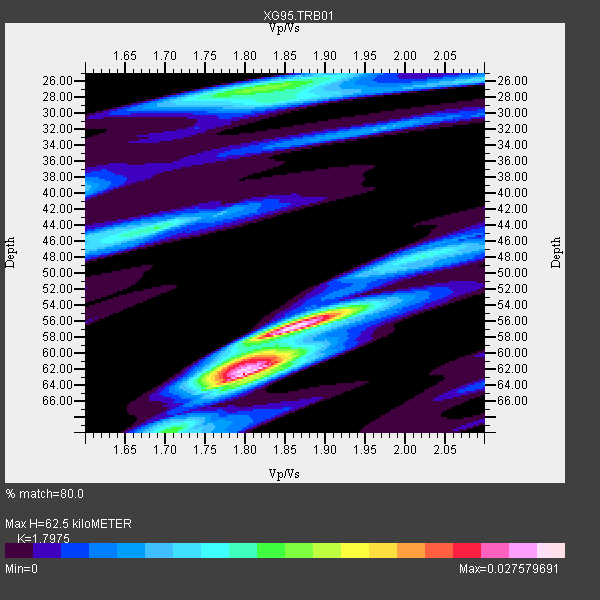
| Thickness Estimate: | 62 km |
| Thickness StdDev: | 7.1 km |
| Vp/Vs Estimate: | 1.80 |
| Vp/Vs StdDev: | 0.06 |
| Vs Estimate: | 3.605 km/s |
| Poisson's Ratio: | 0.28 |
| Peak Value: | 0.03 |
| Assumed Vp: | 6.481 km/s |
| Ps Weight: | 0.33333334 |
| PpPs Weight: | 0.33333334 |
| PsPs Weight: | 0.33333328 |
| Residual Complexity: | 0.746 |
| Nearby stations H: | +- |
| (2.0 deg) Vp/Vs: | +- |
0 with match > 90% ( 0.0 %) and 7 with match > 80% ( 23.333334 %) out of 30.
Download stack as xyz text file.
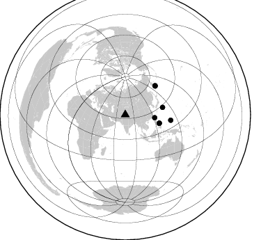
Azimuth Distribution of Events:
Prior Results for this Station
| Study | Thickness | Vp/Vs | Vp | Vs | Poissons Ratio | Extra |
| EARS | 62 km | 1.80 | 6.481 km/s | 3.605 km/s | 0.28 | |
| Crust2.0 | 65 km | 1.76 | 6.481 km/s | 3.685 km/s | 0.26 | R2,orogen/65km Bolivia, 0.5 km seds. |
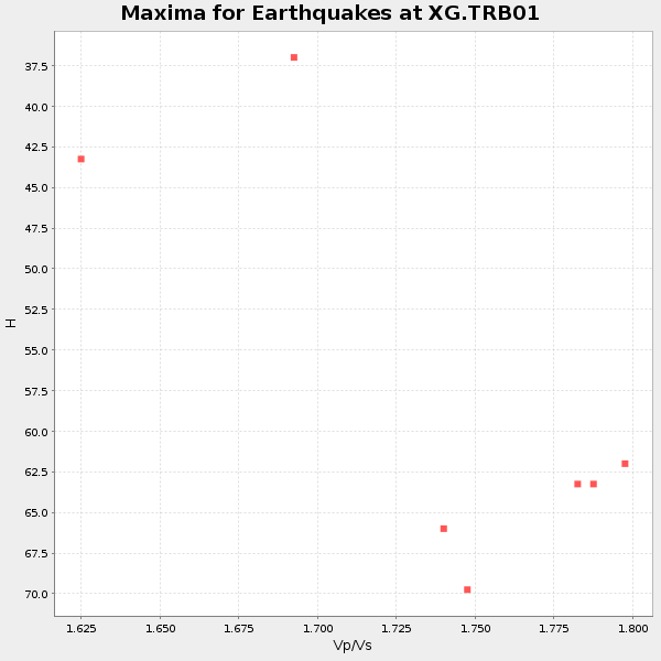
| Global Maxima | 62 km | 1.80 | 6.481 km/s | 3.605 km/s | 0.28 | amp=0.027579691 |
| Local Maxima 1 | 57 km | 1.86 | 6.481 km/s | 3.489 km/s | 0.30 | amp=0.022041228 |
| Local Maxima 2 | 27 km | 1.82 | 6.481 km/s | 3.556 km/s | 0.28 | amp=0.014384641 |
| Local Maxima 3 | 44 km | 1.69 | 6.481 km/s | 3.835 km/s | 0.23 | amp=0.0124243535 |
| Local Maxima 4 | 61 km | 1.79 | 6.481 km/s | 3.626 km/s | 0.27 | amp=0.012239963 |
| Predicted Arrivals for vertical incidence (zero ray parameter) | |
| Ps | 7.69 SECOND |
| PpPs | 26.98 SECOND |
| PsPs/PpSs | 34.67 SECOND |
Events Processed for this Station
Download zip of receiver functions as SAC
Plot maxima for each earthquake.
Events Used in the Stack
(7 events)| Radial Match | Distance | Baz | FERegion | Time | Lat/Lon | Depth | Magnitude |
| 89.84164 | 59.7 deg | 46.205 deg | Off East Coast Of Kamchatka | 1996/06/22 14:50:07 GMT | (51.4, 159.2) | 33 km | 5.6 MB, 6.0 MS, 6.2 UNKNOWN, 6.2 MW |
| 89.70758 | 42.4 deg | 95.937 deg | Taiwan Region | 1996/09/05 23:42:06 GMT | (21.9, 121.5) | 20 km | 6.4 MB, 6.6 MS, 6.8 UNKNOWN, 6.8 ME |
| 87.119064 | 65.9 deg | 96.955 deg | W. Caroline Islands, Micronesia | 1996/07/04 15:50:38 GMT | (8.5, 141.6) | 33 km | 5.1 MB, 5.4 MS, 6.0 UNKNOWN, 5.9 MW |
| 85.98429 | 59.9 deg | 45.705 deg | Off East Coast Of Kamchatka | 1996/06/30 11:32:35 GMT | (51.7, 159.8) | 33 km | 5.5 MB, 5.9 MS, 6.1 UNKNOWN, 6.0 MW |
| 84.77351 | 50.4 deg | 104.075 deg | Samar, Philippines | 1996/06/11 18:22:55 GMT | (12.6, 125.2) | 33 km | 6.0 MB, 7.0 MS, 7.2 UNKNOWN, 7.1 MW |
| 82.30649 | 54.6 deg | 78.954 deg | Bonin Islands, Japan Region | 1996/06/26 03:22:03 GMT | (27.7, 139.7) | 469 km | 5.5 MB, 6.3 UNKNOWN, 5.4 MB |
| 81.26274 | 50.2 deg | 103.942 deg | Samar, Philippines | 1996/06/14 15:04:40 GMT | (12.8, 125.1) | 29 km | 5.6 MB, 5.8 MS, 6.1 UNKNOWN, 5.9 MW |
Losers
(23 events)| Radial Match | Distance | Baz | FERegion | Time | Lat/Lon | Depth | Magnitude | Reason |
| 79.568306 | 53.1 deg | 106.424 deg | Mindanao, Philippines | 1996/09/20 04:10:27 GMT | (9.5, 126.3) | 33 km | 5.8 MB, 6.4 MS, 6.6 UNKNOWN, 6.6 MW | |
| 79.37236 | 86.7 deg | 101.339 deg | Solomon Islands | 1996/09/06 17:03:46 GMT | (-7.3, 155.9) | 33 km | 5.6 MB, 6.1 MS, 6.3 UNKNOWN, 6.2 MW | |
| 78.8466 | 52.5 deg | 69.548 deg | Near East Coast Of Honshu, Japan | 1996/09/11 02:37:14 GMT | (35.5, 140.9) | 55 km | 6.1 MB, 5.7 MS, 6.2 UNKNOWN, 6.1 MW | |
| 76.28021 | 72.1 deg | 39.118 deg | Andreanof Islands, Aleutian Is. | 1996/08/19 04:19:16 GMT | (51.5, -178.4) | 33 km | 5.7 MB, 5.6 MS, 6.0 UNKNOWN, 5.7 ML | |
| 74.81345 | 53.3 deg | 106.246 deg | Mindanao, Philippines | 1996/09/20 12:24:42 GMT | (9.4, 126.5) | 33 km | 5.4 MB, 6.0 MS, 6.3 UNKNOWN, 6.0 MW | |
| 74.38571 | 61.6 deg | 123.874 deg | Flores Sea | 1996/06/17 11:22:18 GMT | (-7.1, 122.6) | 587 km | 6.6 MB, 7.9 UNKNOWN, 7.8 MW | |
| 74.16617 | 48.4 deg | 16.482 deg | Laptev Sea | 1996/06/22 16:47:12 GMT | (75.8, 134.6) | 10 km | 5.6 MB, 5.5 MS, 5.8 UNKNOWN, 5.7 MW | |
| 73.399506 | 53.2 deg | 106.395 deg | Mindanao, Philippines | 1996/09/20 04:11:04 GMT | (9.5, 126.3) | 33 km | 5.9 MB | |
| 72.20629 | 56.7 deg | 38.379 deg | Kamchatka Peninsula, Russia | 1996/07/07 10:49:59 GMT | (58.6, 157.8) | 10 km | 5.6 MB, 5.6 MS, 5.8 UNKNOWN, 5.8 MW | |
| 70.149635 | 51.2 deg | 104.347 deg | Samar, Philippines | 1996/08/08 23:12:35 GMT | (12.0, 125.7) | 33 km | 5.5 MS, 5.4 MB | |
| 70.06216 | 86.4 deg | 101.357 deg | Solomon Islands | 1996/09/07 09:06:00 GMT | (-7.2, 155.7) | 10 km | 5.6 MS, 5.4 MB, 5.8 UNKNOWN, 5.7 MW | |
| 69.902695 | 45.2 deg | 106.029 deg | Luzon, Philippines | 1996/07/30 17:38:30 GMT | (14.5, 120.0) | 33 km | 6.1 MB, 5.7 MS, 6.1 UNKNOWN, 5.9 MW | |
| 69.31526 | 53.3 deg | 106.05 deg | Mindanao, Philippines | 1996/09/20 19:24:57 GMT | (9.6, 126.6) | 33 km | 5.5 MB, 5.6 MS, 5.9 UNKNOWN, 5.8 MW | |
| 67.0043 | 85.3 deg | 101.323 deg | Solomon Islands | 1996/09/15 18:17:38 GMT | (-6.5, 154.8) | 50 km | 5.7 MB, 5.8 MS, 5.9 UNKNOWN, 5.9 MW | |
| 66.12384 | 54.8 deg | 46.854 deg | Sea Of Okhotsk | 1996/08/30 21:13:41 GMT | (52.3, 151.5) | 580 km | 5.5 UNKNOWN, 5.1 MB, 5.4 MW | |
| 64.89531 | 86.6 deg | 101.345 deg | Solomon Islands | 1996/09/06 12:39:41 GMT | (-7.3, 155.8) | 33 km | 5.5 MB, 5.8 MS, 5.9 UNKNOWN, 5.9 MW | |
| 64.61551 | 96.9 deg | 98.409 deg | Santa Cruz Islands | 1996/09/14 13:10:53 GMT | (-10.9, 166.0) | 73 km | 6.0 MB, 6.0 MS, 6.4 UNKNOWN, 6.4 MW | |
| 63.72322 | 54.1 deg | 119.246 deg | Minahassa Peninsula, Sulawesi | 1996/07/28 10:40:43 GMT | (1.0, 120.2) | 33 km | 5.5 MB, 5.5 MS, 6.0 UNKNOWN, 5.9 MW | |
| 60.32095 | 58.5 deg | 116.262 deg | Southern Molucca Sea | 1996/08/12 17:00:27 GMT | (-0.3, 125.1) | 42 km | 5.7 MB, 5.5 MS, 6.1 UNKNOWN, 6.0 MW | |
| 59.145927 | 62.0 deg | 123.3 deg | Banda Sea | 1996/08/22 05:35:42 GMT | (-7.1, 123.3) | 596 km | 5.8 MB, 5.9 UNKNOWN, 5.8 MW | |
| 55.030945 | 56.6 deg | 117.915 deg | Minahassa Peninsula, Sulawesi | 1996/09/14 02:53:24 GMT | (-0.0, 122.8) | 181 km | 5.5 MB | |
| 48.55872 | 76.9 deg | 176.0 deg | Mid-Indian Ridge | 1996/08/19 06:24:11 GMT | (-41.5, 80.4) | 10 km | 5.4 MB, 5.9 MS, 6.0 UNKNOWN, 5.9 MW | |
| 34.59035 | 72.2 deg | 177.254 deg | Mid-Indian Ridge | 1996/08/27 10:50:49 GMT | (-36.9, 78.5) | 10 km | 5.8 MS, 5.3 MB, 5.9 UNKNOWN, 5.9 MW |
