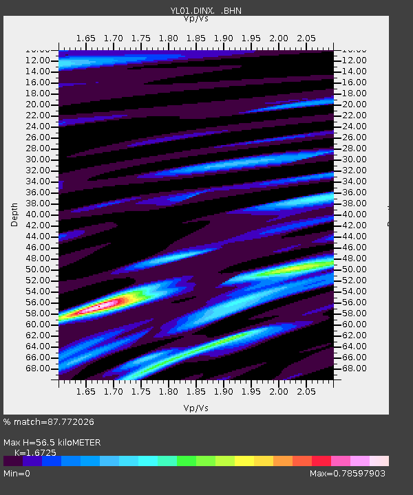
DINX YL.DINX - Earthquake Result Viewer
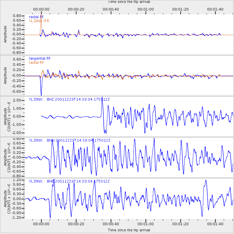
Earthquake location: Southwest Of Sumatra, Indonesia
Earthquake latitude/longitude: -6.0/102.8
Earthquake time(UTC): 2001/12/29 (363) 14:32:22 GMT
Earthquake Depth: 33 km
Earthquake Magnitude: 5.6 MB, 5.7 MS, 5.8 MW, 5.6 MW
Earthquake Catalog/Contributor: WHDF/NEIC
Network: YL Himalayan Nepal Tibet Experiment
Station: DINX YL.DINX
Lat/Lon: 28.66 N/87.12 E
Elevation: 4374 m
Distance: 37.7 deg
Az: 337.044 deg
Baz: 153.806 deg
Ray Param: 0.07594831
Estimated Moho Depth: 56.5 km
Estimated Crust Vp/Vs: 1.67
Assumed Crust Vp: 6.514 km/s
Estimated Crust Vs: 3.895 km/s
Estimated Crust Poisson's Ratio: 0.22
Radial Match: 87.772026 %
Radial Bump: 400
Transverse Match: 89.72939 %
Transverse Bump: 323
SOD ConfigId: 16820
Insert Time: 2010-02-26 15:53:07.558 +0000
GWidth: 2.5
Max Bumps: 400
Tol: 0.001

Signal To Noise

ChannelStoNSTALTA
YL:DINX: :BHN:20011229T14:39:04.175012Z2.29545551.1129511E-74.848498E-8
YL:DINX: :BHE:20011229T14:39:04.175012Z2.6966731.4707138E-75.4538084E-8
YL:DINX: :BHZ:20011229T14:39:04.175012Z4.8078934.243555E-78.826226E-8
Arrivals
Ps6.3 SECOND
PpPs21 SECOND
PsPs/PpSs28 SECOND