
Station YL DINX - YL.DINX
Network: YL01 - Himalayan Nepal Tibet Experiment
Nearby stations (2 deg radius)
| Station | Name | (Lat, Lon) | Start / End | Elevation |
| DINX | YL.DINX | (28.66, 87.12) | 2001-09-07 / 2003-01-01 | 4374 m |
| Crust2 Type: | RD,orogen/70km Tibet, no seds. |
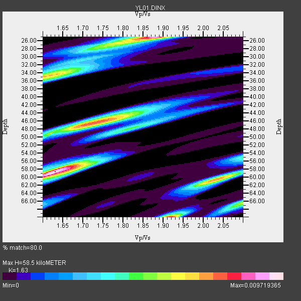
| Thickness Estimate: | 58 km |
| Thickness StdDev: | 9.7 km |
| Vp/Vs Estimate: | 1.63 |
| Vp/Vs StdDev: | 0.16 |
| Vs Estimate: | 3.996 km/s |
| Poisson's Ratio: | 0.20 |
| Peak Value: | 0.01 |
| Assumed Vp: | 6.514 km/s |
| Ps Weight: | 0.33333334 |
| PpPs Weight: | 0.33333334 |
| PsPs Weight: | 0.33333328 |
| Residual Complexity: | 0.872 |
| Nearby stations H: | +- |
| (2.0 deg) Vp/Vs: | +- |
3 with match > 90% ( 7.3170733 %) and 9 with match > 80% ( 21.95122 %) out of 41.
Download stack as xyz text file.
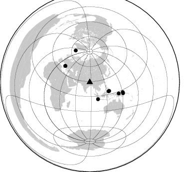
Azimuth Distribution of Events:
Prior Results for this Station
| Study | Thickness | Vp/Vs | Vp | Vs | Poissons Ratio | Extra |
| EARS | 58 km | 1.63 | 6.514 km/s | 3.996 km/s | 0.20 | |
| Crust2.0 | 70 km | 1.76 | 6.514 km/s | 3.706 km/s | 0.26 | RD,orogen/70km Tibet, no seds. |
| Global Maxima | 58 km | 1.63 | 6.514 km/s | 3.996 km/s | 0.20 | amp=0.009719365 |
| Local Maxima 1 | 25 km | 1.88 | 6.514 km/s | 3.47 km/s | 0.30 | amp=0.00906111 |
| Local Maxima 2 | 70 km | 1.92 | 6.514 km/s | 3.393 km/s | 0.31 | amp=0.007856169 |
| Local Maxima 3 | 46 km | 1.72 | 6.514 km/s | 3.782 km/s | 0.25 | amp=0.007535415 |
| Local Maxima 4 | 34 km | 1.62 | 6.514 km/s | 4.027 km/s | 0.19 | amp=0.006947762 |
| Predicted Arrivals for vertical incidence (zero ray parameter) | |
| Ps | 5.66 SECOND |
| PpPs | 23.62 SECOND |
| PsPs/PpSs | 29.28 SECOND |
Events Processed for this Station
Download zip of receiver functions as SAC
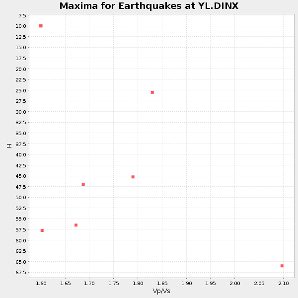
Plot maxima for each earthquake.
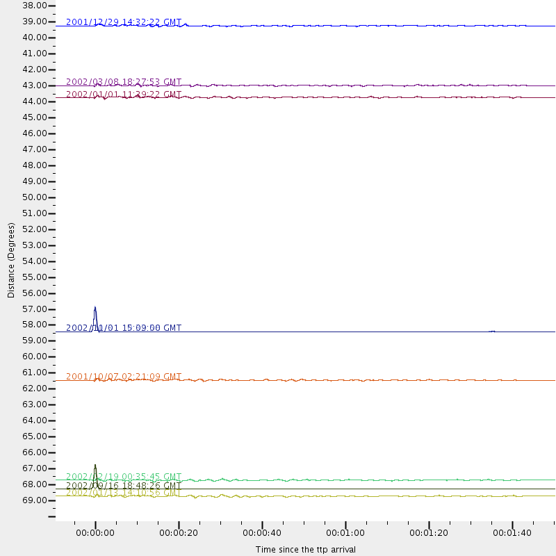
Events Used in the Stack
(9 events)| Radial Match | Distance | Baz | FERegion | Time | Lat/Lon | Depth | Magnitude |
| 99.986694 | 69.8 deg | 336.145 deg | Iceland Region | 2002/09/16 18:48:26 GMT | (66.9, -18.5) | 10 km | 5.5 MB, 5.7 MS, 5.8 MW, 5.8 MW |
| 99.96944 | 58.9 deg | 303.679 deg | Southern Italy | 2002/10/31 10:32:58 GMT | (41.8, 14.9) | 10 km | 5.3 MB, 5.6 MS, 5.9 MW, 5.7 MW |
| 99.96744 | 58.9 deg | 303.606 deg | Southern Italy | 2002/11/01 15:09:00 GMT | (41.7, 14.9) | 10 km | 5.5 MB, 5.6 MS, 5.8 MW, 5.7 MW |
| 87.772026 | 37.7 deg | 153.806 deg | Southwest Of Sumatra, Indonesia | 2001/12/29 14:32:22 GMT | (-6.0, 102.8) | 33 km | 5.6 MB, 5.7 MS, 5.8 MW, 5.6 MW |
| 85.995026 | 42.7 deg | 113.962 deg | Mindanao, Philippines | 2002/01/01 11:29:22 GMT | (6.3, 125.7) | 138 km | 5.9 MB, 6.3 MW, 6.3 MW |
| 85.50061 | 69.2 deg | 106.564 deg | New Ireland Region, P.N.G. | 2002/02/19 00:35:45 GMT | (-3.7, 151.0) | 10 km | 5.9 MB, 6.0 MS, 6.1 MW, 6.1 MW |
| 84.74497 | 62.2 deg | 111.049 deg | Near N Coast Of New Guinea, P.N.G. | 2001/10/07 02:21:09 GMT | (-3.3, 142.9) | 10 km | 5.7 MB, 6.1 MS, 6.2 MW, 6.2 MW |
| 81.67938 | 41.8 deg | 115.689 deg | Mindanao, Philippines | 2002/03/08 18:27:53 GMT | (5.9, 124.3) | 23 km | 5.6 MB, 5.7 MS, 6.0 MW, 5.8 MW |
| 80.06249 | 70.3 deg | 108.227 deg | New Britain Region, P.N.G. | 2002/01/13 14:10:56 GMT | (-5.7, 151.1) | 44 km | 5.9 MB, 6.4 MS, 6.3 MW, 6.3 MW |
Losers
(32 events)| Radial Match | Distance | Baz | FERegion | Time | Lat/Lon | Depth | Magnitude | Reason |
| 97.415054 | 44.2 deg | 126.284 deg | Sulawesi, Indonesia | 2002/08/15 05:30:26 GMT | (-1.2, 121.3) | 10 km | 5.7 MB, 5.8 MS, 6.2 MW, 6.1 MW | |
| 91.011475 | 77.0 deg | 171.293 deg | Southeast Indian Ridge | 2002/06/13 01:27:19 GMT | (-47.8, 99.8) | 10 km | 5.5 MB, 6.6 MS, 6.6 MW, 6.5 MW | |
| 90.914406 | 86.8 deg | 106.115 deg | Santa Cruz Islands | 2002/06/17 21:26:22 GMT | (-12.6, 166.4) | 33 km | 6.0 MB, 6.7 MS, 6.7 MW, 6.6 MW | |
| 88.45286 | 79.0 deg | 34.126 deg | South Of Alaska | 2002/05/25 05:36:31 GMT | (53.8, -161.1) | 33 km | 5.5 MB, 6.1 MS, 6.5 MW, 6.4 MW | |
| 86.96297 | 39.1 deg | 152.461 deg | Sunda Strait, Indonesia | 2002/06/27 05:50:35 GMT | (-7.0, 104.2) | 11 km | 6.0 MB, 6.9 MS, 6.6 MW, 6.5 MW | |
| 85.72406 | 65.3 deg | 187.252 deg | Mid-Indian Ridge | 2002/05/14 16:56:10 GMT | (-36.5, 78.9) | 10 km | 5.6 MB, 6.1 MS, 6.3 MW, 6.1 MW | |
| 82.14284 | 42.0 deg | 126.016 deg | Minahassa Peninsula, Sulawesi | 2002/06/16 00:00:25 GMT | (0.5, 119.9) | 35 km | 5.7 MB, 5.5 MS, 5.9 MW, 5.8 MW | |
| 78.788216 | 46.6 deg | 117.606 deg | Halmahera, Indonesia | 2002/05/26 00:10:21 GMT | (1.8, 127.2) | 109 km | 5.8 MB, 5.9 MW, 5.8 MW | |
| 78.16085 | 34.2 deg | 151.752 deg | Southern Sumatra, Indonesia | 2002/06/16 18:31:10 GMT | (-2.3, 102.6) | 232 km | 5.8 MW, 5.4 MB, 5.7 MW | |
| 75.4787 | 52.7 deg | 295.851 deg | Southern Greece | 2002/05/21 20:53:29 GMT | (36.6, 24.3) | 97 km | 5.4 MB, 5.6 MD | |
| 72.80736 | 87.7 deg | 106.376 deg | Vanuatu Islands | 2002/06/27 07:16:10 GMT | (-13.3, 167.1) | 187 km | 6.0 MB, 6.1 MW | |
| 67.62631 | 57.9 deg | 42.181 deg | Near East Coast Of Kamchatka | 2002/05/08 19:45:18 GMT | (53.8, 160.8) | 39 km | 5.8 MB, 5.4 MS, 5.9 MW, 5.8 MW | |
| 66.662674 | 48.5 deg | 136.447 deg | Sumbawa Region, Indonesia | 2002/07/24 03:05:05 GMT | (-9.3, 118.6) | 29 km | 5.8 MB, 5.4 MS, 5.9 MW, 5.9 MW | |
| 66.46619 | 32.5 deg | 99.337 deg | Philippine Islands Region | 2002/05/13 19:57:22 GMT | (19.1, 121.2) | 33 km | 5.6 MB, 5.3 MS, 5.8 MW | |
| 65.43742 | 81.8 deg | 107.214 deg | Solomon Islands | 2002/10/03 04:26:06 GMT | (-11.0, 161.4) | 10 km | 5.6 MB, 5.6 MS, 5.9 MW, 5.7 MW | |
| 63.88828 | 31.8 deg | 90.029 deg | Taiwan Region | 2002/05/28 16:45:17 GMT | (24.1, 122.3) | 33 km | 5.8 MB, 5.9 MS, 6.0 MW, 6.0 MW | |
| 60.90376 | 81.6 deg | 107.297 deg | Solomon Islands | 2002/10/01 08:46:55 GMT | (-10.9, 161.2) | 10 km | 5.7 MB, 5.5 MS, 5.8 MW, 5.6 MW | |
| 59.94769 | 37.8 deg | 54.59 deg | E. Russia-N.E. China Border Reg. | 2002/06/28 17:19:30 GMT | (43.8, 130.7) | 566 km | 6.7 MB, 7.3 MW, 7.3 MW | |
| 54.749195 | 31.8 deg | 90.006 deg | Taiwan Region | 2002/07/11 07:36:26 GMT | (24.1, 122.3) | 44 km | 5.6 MB, 5.6 MS, 5.8 MW, 5.8 MW | |
| 54.19843 | 70.4 deg | 179.001 deg | Southeast Indian Ridge | 2002/10/08 01:23:58 GMT | (-42.0, 88.4) | 10 km | 5.3 MB, 5.7 MS, 6.0 MW, 5.9 MW | |
| 54.11442 | 46.2 deg | 59.119 deg | Hokkaido, Japan Region | 2002/10/14 14:12:43 GMT | (41.2, 142.2) | 61 km | 5.9 MB, 6.1 MW, 6.1 MW | |
| 53.981968 | 51.7 deg | 54.531 deg | Kuril Islands | 2002/10/19 12:09:05 GMT | (44.3, 150.0) | 33 km | 5.4 MB, 6.2 MS, 6.4 MW, 6.1 MW | |
| 53.62386 | 60.2 deg | 113.111 deg | Irian Jaya, Indonesia | 2002/10/17 17:52:44 GMT | (-3.6, 140.2) | 33 km | 5.6 MB, 6.2 MS, 6.3 MW, 6.3 MW | |
| 52.92011 | 81.4 deg | 107.049 deg | Solomon Islands | 2002/09/24 23:01:28 GMT | (-10.6, 161.2) | 19 km | 5.7 MB, 6.5 MS, 6.3 MW, 6.3 MW | |
| 51.22684 | 47.2 deg | 73.032 deg | Southeast Of Honshu, Japan | 2002/08/20 10:59:32 GMT | (31.0, 142.0) | 9.0 km | 5.4 MB, 6.2 MS, 6.3 MW, 6.1 MW | |
| 50.48742 | 32.0 deg | 108.266 deg | Philippine Islands Region | 2002/10/12 23:43:12 GMT | (15.1, 118.5) | 33 km | 5.6 MB, 5.6 MS, 6.1 MW | |
| 50.173973 | 37.4 deg | 52.696 deg | Northeastern China | 2002/09/15 08:39:32 GMT | (44.8, 129.9) | 586 km | 5.8 MB, 6.4 MW, 6.4 MW | |
| 45.82218 | 35.6 deg | 253.755 deg | Eastern Gulf Of Aden | 2002/09/01 17:14:59 GMT | (14.3, 51.9) | 10 km | 5.8 MS, 5.2 MB, 6.0 MW, 6.0 MW | |
| 40.927223 | 34.7 deg | 108.667 deg | Mindoro, Philippines | 2002/09/03 14:23:45 GMT | (13.5, 120.8) | 10 km | 5.5 MB, 5.4 MS, 5.9 MW, 5.8 MW | |
| 39.925133 | 54.1 deg | 115.436 deg | Irian Jaya Region, Indonesia | 2002/10/10 18:33:37 GMT | (-1.5, 134.1) | 10 km | 5.5 MS, 5.4 MB | |
| 38.241093 | 45.1 deg | 76.095 deg | Southeast Of Honshu, Japan | 2002/08/02 23:11:39 GMT | (29.3, 139.0) | 426 km | 5.5 MB, 6.3 MW, 6.3 MW | |
| 35.679817 | 51.2 deg | 103.848 deg | W. Caroline Islands, Micronesia | 2002/08/14 13:12:39 GMT | (7.8, 136.9) | 10 km | 6.1 MB, 6.0 MS, 6.3 MW, 6.3 MW |
