You are here: Home > Network List > OE - Austrian Seismic Network Stations List
> Station DAVA Damuels, Vorarlberg, Austria > Earthquake Result Viewer
DAVA Damuels, Vorarlberg, Austria - Earthquake Result Viewer
| Earthquake location: |
Kuril Islands |
| Earthquake latitude/longitude: |
48.8/155.0 |
| Earthquake time(UTC): |
2021/08/24 (236) 05:37:51 GMT |
| Earthquake Depth: |
31 km |
| Earthquake Magnitude: |
6.0 mww |
| Earthquake Catalog/Contributor: |
NEIC PDE/us |
|
| Network: |
OE Austrian Seismic Network |
| Station: |
DAVA Damuels, Vorarlberg, Austria |
| Lat/Lon: |
47.29 N/9.88 E |
| Elevation: |
1602 m |
|
| Distance: |
79.6 deg |
| Az: |
336.655 deg |
| Baz: |
22.628 deg |
| Ray Param: |
0.048818216 |
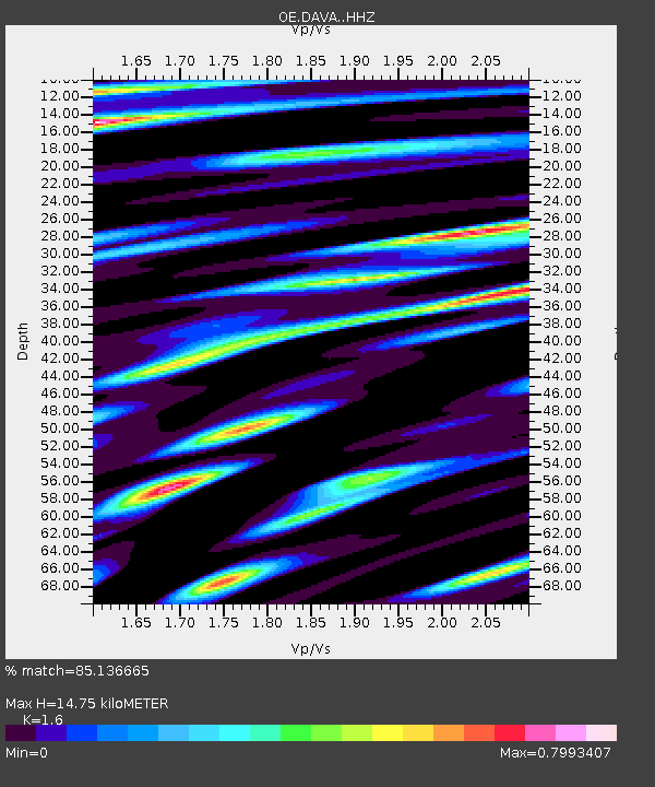
| Estimated Moho Depth: |
14.75 km |
| Estimated Crust Vp/Vs: |
1.60 |
| Assumed Crust Vp: |
6.416 km/s |
| Estimated Crust Vs: |
4.01 km/s |
| Estimated Crust Poisson's Ratio: |
0.18 |
|
| Radial Match: |
85.136665 % |
| Radial Bump: |
400 |
| Transverse Match: |
70.66376 % |
| Transverse Bump: |
400 |
| SOD ConfigId: |
25131211 |
| Insert Time: |
2021-09-07 06:03:00.399 +0000 |
| GWidth: |
2.5 |
| Max Bumps: |
400 |
| Tol: |
0.001 |
|

Signal To Noise
| Channel | StoN | STA | LTA |
| OE:DAVA: :HHZ:20210824T05:49:24.108002Z | 17.934074 | 1.1128707E-6 | 6.2053424E-8 |
| OE:DAVA: :HHN:20210824T05:49:24.108002Z | 6.299725 | 3.0859118E-7 | 4.8984862E-8 |
| OE:DAVA: :HHE:20210824T05:49:24.108002Z | 5.0145593 | 2.0376564E-7 | 4.0634802E-8 |
| Arrivals |
| Ps | 1.4 SECOND |
| PpPs | 5.8 SECOND |
| PsPs/PpSs | 7.2 SECOND |


