You are here: Home > Network List > IM - International Miscellaneous Stations Stations List
> Station NV32 NVAR Array, Mina, NV, USA > Earthquake Result Viewer
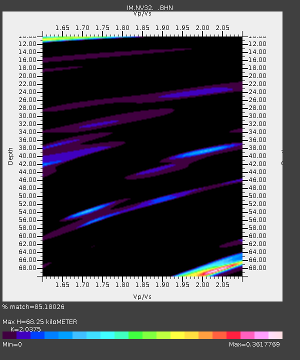
NV32 NVAR Array, Mina, NV, USA - Earthquake Result Viewer
| Earthquake location: |
Vanuatu Islands Region |
| Earthquake latitude/longitude: |
-20.9/173.8 |
| Earthquake time(UTC): |
2005/08/09 (221) 05:26:17 GMT |
| Earthquake Depth: |
24 km |
| Earthquake Magnitude: |
5.5 MB, 6.0 MS, 6.1 MW, 6.1 MW |
| Earthquake Catalog/Contributor: |
WHDF/NEIC |
|
| Network: |
IM International Miscellaneous Stations |
| Station: |
NV32 NVAR Array, Mina, NV, USA |
| Lat/Lon: |
38.33 N/118.30 W |
| Elevation: |
1829 m |
|
| Distance: |
86.7 deg |
| Az: |
46.863 deg |
| Baz: |
240.151 deg |
| Ray Param: |
0.043828566 |
| Estimated Moho Depth: |
68.25 km |
| Estimated Crust Vp/Vs: |
2.04 |
| Assumed Crust Vp: |
6.279 km/s |
| Estimated Crust Vs: |
3.082 km/s |
| Estimated Crust Poisson's Ratio: |
0.34 |
|
| Radial Match: |
85.18026 % |
| Radial Bump: |
400 |
| Transverse Match: |
81.46545 % |
| Transverse Bump: |
400 |
| SOD ConfigId: |
2475 |
| Insert Time: |
2010-03-09 11:57:41.861 +0000 |
| GWidth: |
2.5 |
| Max Bumps: |
400 |
| Tol: |
0.001 |
|

Signal To Noise
| Channel | StoN | STA | LTA |
| IM:NV32: :BHN:20050809T05:38:27.92502Z | 1.2617261 | 5.6157813E-5 | 4.4508717E-5 |
| IM:NV32: :BHE:20050809T05:38:27.92502Z | 2.390508 | 3.319193E-5 | 1.3884885E-5 |
| IM:NV32: :BHZ:20050809T05:38:27.92502Z | 3.7504668 | 1.738302E-4 | 4.6348952E-5 |
| Arrivals |
| Ps | 11 SECOND |
| PpPs | 32 SECOND |
| PsPs/PpSs | 44 SECOND |


