
Station IM NV32 - NVAR Array, Mina, NV, USA
Network: IM - International Miscellaneous Stations
Nearby stations (2 deg radius)
| Station | Name | (Lat, Lon) | Start / End | Elevation |
| NV32 | NVAR Array, Mina, NV, USA | (38.33, -118.30) | 1970-01-24 / 2499-01-01 | 1829 m |
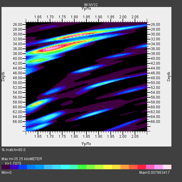
| Crust2 Type: | M7,medium thick extended crust, 0.5 km seds. |
| Thickness Estimate: | 35 km |
| Thickness StdDev: | 12 km |
| Vp/Vs Estimate: | 1.71 |
| Vp/Vs StdDev: | 0.09 |
| Vs Estimate: | 3.677 km/s |
| Poisson's Ratio: | 0.24 |
| Peak Value: | 0.01 |
| Assumed Vp: | 6.279 km/s |
| Ps Weight: | 0.33333334 |
| PpPs Weight: | 0.33333334 |
| PsPs Weight: | 0.33333328 |
| Residual Complexity: | 0.662 |
| Nearby stations H: | +- |
| (2.0 deg) Vp/Vs: | +- |
4 with match > 90% ( 33.333332 %) and 12 with match > 80% ( 100.0 %) out of 12.
Download stack as xyz text file.
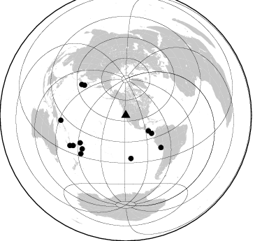
Azimuth Distribution of Events:
Prior Results for this Station
| Study | Thickness | Vp/Vs | Vp | Vs | Poissons Ratio | Extra |
| EARS | 35 km | 1.71 | 6.279 km/s | 3.677 km/s | 0.24 | |
| Crust2.0 | 35 km | 1.78 | 6.279 km/s | 3.533 km/s | 0.27 | M7,medium thick extended crust, 0.5 km seds. |
| Global Maxima | 35 km | 1.71 | 6.279 km/s | 3.677 km/s | 0.24 | amp=0.007863417 |
| Local Maxima 1 | 30 km | 1.82 | 6.279 km/s | 3.445 km/s | 0.28 | amp=0.0062967394 |
| Local Maxima 2 | 58 km | 1.64 | 6.279 km/s | 3.823 km/s | 0.21 | amp=0.0055434015 |
| Local Maxima 3 | 32 km | 1.86 | 6.279 km/s | 3.38 km/s | 0.30 | amp=0.0035496755 |
| Local Maxima 4 | 50 km | 1.91 | 6.279 km/s | 3.292 km/s | 0.31 | amp=0.003444876 |
| Predicted Arrivals for vertical incidence (zero ray parameter) | |
| Ps | 3.97 SECOND |
| PpPs | 15.20 SECOND |
| PsPs/PpSs | 19.17 SECOND |
Events Processed for this Station
Download zip of receiver functions as SAC
Plot maxima for each earthquake.
Events Used in the Stack
(12 events)| Radial Match | Distance | Baz | FERegion | Time | Lat/Lon | Depth | Magnitude |
| 97.03216 | 62.1 deg | 173.141 deg | Easter Island Region | 2005/07/11 12:01:35 GMT | (-23.8, -111.7) | 10 km | 6.0 MB, 5.4 MS, 5.8 MW, 5.8 MW |
| 94.15401 | 39.4 deg | 124.667 deg | Near Coast Of Nicaragua | 2005/07/02 02:16:43 GMT | (11.2, -86.2) | 27 km | 5.6 MB, 6.4 MS, 6.6 MW, 6.6 MW |
| 92.73635 | 76.2 deg | 238.781 deg | Fiji Islands Region | 2005/08/07 11:35:26 GMT | (-14.4, -177.3) | 10 km | 5.7 MB, 5.9 MS, 6.0 MW, 6.0 MW |
| 90.77524 | 84.7 deg | 229.474 deg | Kermadec Islands Region | 2005/07/11 23:06:01 GMT | (-27.0, -176.3) | 10 km | 5.5 MB, 5.7 MS, 6.0 MW, 5.9 MW |
| 86.64559 | 76.9 deg | 304.882 deg | Near S. Coast Of Honshu, Japan | 2005/07/23 07:34:56 GMT | (35.5, 140.0) | 61 km | 6.1 MB, 6.0 MW, 6.0 MW |
| 86.49678 | 78.6 deg | 232.403 deg | Tonga Islands | 2005/10/05 10:07:22 GMT | (-20.5, -174.3) | 15 km | 6.0 MB, 5.7 MS, 6.0 MW, 6.0 MW |
| 86.1232 | 93.2 deg | 265.662 deg | New Britain Region, P.N.G. | 2005/09/29 15:50:24 GMT | (-5.4, 151.8) | 25 km | 5.9 MB, 6.6 MS, 6.7 MW, 6.5 MW |
| 85.77793 | 90.8 deg | 241.576 deg | Southeast Of Loyalty Islands | 2005/08/11 09:08:46 GMT | (-22.7, 169.5) | 10 km | 5.7 MB, 6.0 MS, 6.2 MW, 6.2 MW |
| 85.18026 | 86.7 deg | 240.151 deg | Vanuatu Islands Region | 2005/08/09 05:26:17 GMT | (-20.9, 173.8) | 24 km | 5.5 MB, 6.0 MS, 6.1 MW, 6.1 MW |
| 84.75848 | 68.2 deg | 132.36 deg | Southern Peru | 2005/07/26 14:11:36 GMT | (-15.3, -73.0) | 110 km | 5.8 MB, 6.0 MW, 5.9 MW |
| 81.53361 | 45.1 deg | 124.797 deg | South Of Panama | 2005/08/27 18:38:20 GMT | (6.8, -82.4) | 10 km | 5.6 MB, 5.6 MS, 6.2 MW, 6.1 MW |
| 80.88329 | 73.1 deg | 305.932 deg | Near East Coast Of Honshu, Japan | 2005/08/24 10:15:28 GMT | (38.6, 143.0) | 10 km | 6.0 MB, 5.6 MS, 6.2 MW |
Losers
(0 events)| Radial Match | Distance | Baz | FERegion | Time | Lat/Lon | Depth | Magnitude | Reason |
