You are here: Home > Network List > IM - International Miscellaneous Stations Stations List
> Station NV32 NVAR Array, Mina, NV, USA > Earthquake Result Viewer
NV32 NVAR Array, Mina, NV, USA - Earthquake Result Viewer
| Earthquake location: |
Easter Island Region |
| Earthquake latitude/longitude: |
-23.8/-111.7 |
| Earthquake time(UTC): |
2005/07/11 (192) 12:01:35 GMT |
| Earthquake Depth: |
10 km |
| Earthquake Magnitude: |
6.0 MB, 5.4 MS, 5.8 MW, 5.8 MW |
| Earthquake Catalog/Contributor: |
WHDF/NEIC |
|
| Network: |
IM International Miscellaneous Stations |
| Station: |
NV32 NVAR Array, Mina, NV, USA |
| Lat/Lon: |
38.33 N/118.30 W |
| Elevation: |
1829 m |
|
| Distance: |
62.1 deg |
| Az: |
354.114 deg |
| Baz: |
173.141 deg |
| Ray Param: |
0.06042688 |
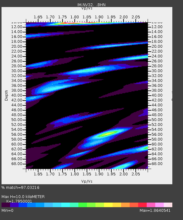
| Estimated Moho Depth: |
10.0 km |
| Estimated Crust Vp/Vs: |
1.80 |
| Assumed Crust Vp: |
6.279 km/s |
| Estimated Crust Vs: |
3.498 km/s |
| Estimated Crust Poisson's Ratio: |
0.27 |
|
| Radial Match: |
97.03216 % |
| Radial Bump: |
375 |
| Transverse Match: |
91.41891 % |
| Transverse Bump: |
400 |
| SOD ConfigId: |
2475 |
| Insert Time: |
2010-03-09 11:57:43.878 +0000 |
| GWidth: |
2.5 |
| Max Bumps: |
400 |
| Tol: |
0.001 |
|

Signal To Noise
| Channel | StoN | STA | LTA |
| IM:NV32: :BHN:20050711T12:11:25.25002Z | 8.594945 | 3.8253397E-4 | 4.4506854E-5 |
| IM:NV32: :BHE:20050711T12:11:25.25002Z | 2.2963166 | 3.4070064E-5 | 1.4836832E-5 |
| IM:NV32: :BHZ:20050711T12:11:25.25002Z | 15.639156 | 8.227901E-4 | 5.2610903E-5 |
| Arrivals |
| Ps | 1.3 SECOND |
| PpPs | 4.3 SECOND |
| PsPs/PpSs | 5.6 SECOND |


