You are here: Home > Network List > IM - International Miscellaneous Stations Stations List
> Station NV32 NVAR Array, Mina, NV, USA > Earthquake Result Viewer
NV32 NVAR Array, Mina, NV, USA - Earthquake Result Viewer
| Earthquake location: |
Kermadec Islands Region |
| Earthquake latitude/longitude: |
-27.0/-176.3 |
| Earthquake time(UTC): |
2005/07/11 (192) 23:06:01 GMT |
| Earthquake Depth: |
10 km |
| Earthquake Magnitude: |
5.5 MB, 5.7 MS, 6.0 MW, 5.9 MW |
| Earthquake Catalog/Contributor: |
WHDF/NEIC |
|
| Network: |
IM International Miscellaneous Stations |
| Station: |
NV32 NVAR Array, Mina, NV, USA |
| Lat/Lon: |
38.33 N/118.30 W |
| Elevation: |
1829 m |
|
| Distance: |
84.7 deg |
| Az: |
42.065 deg |
| Baz: |
229.474 deg |
| Ray Param: |
0.04530662 |
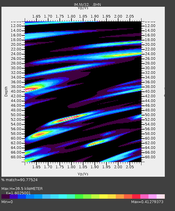
| Estimated Moho Depth: |
39.5 km |
| Estimated Crust Vp/Vs: |
1.60 |
| Assumed Crust Vp: |
6.279 km/s |
| Estimated Crust Vs: |
3.918 km/s |
| Estimated Crust Poisson's Ratio: |
0.18 |
|
| Radial Match: |
90.77524 % |
| Radial Bump: |
400 |
| Transverse Match: |
89.0712 % |
| Transverse Bump: |
400 |
| SOD ConfigId: |
2475 |
| Insert Time: |
2010-03-09 11:57:44.883 +0000 |
| GWidth: |
2.5 |
| Max Bumps: |
400 |
| Tol: |
0.001 |
|

Signal To Noise
| Channel | StoN | STA | LTA |
| IM:NV32: :BHN:20050711T23:18:04.148997Z | 1.5274718 | 7.4072916E-5 | 4.8493803E-5 |
| IM:NV32: :BHE:20050711T23:18:04.148997Z | 1.3999593 | 3.494912E-5 | 2.4964385E-5 |
| IM:NV32: :BHZ:20050711T23:18:04.148997Z | 5.2837663 | 2.9736207E-4 | 5.627843E-5 |
| Arrivals |
| Ps | 3.9 SECOND |
| PpPs | 16 SECOND |
| PsPs/PpSs | 20 SECOND |


