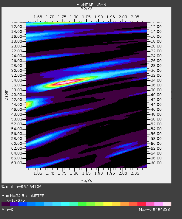
VNDAB Station B, Vanda, Antarctica - Earthquake Result Viewer

Earthquake location: Irian Jaya Region, Indonesia
Earthquake latitude/longitude: -3.6/135.4
Earthquake time(UTC): 2004/11/26 (331) 02:25:03 GMT
Earthquake Depth: 10 km
Earthquake Magnitude: 6.2 MB, 7.2 MS, 7.1 MW, 7.0 MW
Earthquake Catalog/Contributor: WHDF/NEIC
Network: IM International Miscellaneous Stations
Station: VNDAB Station B, Vanda, Antarctica
Lat/Lon: 77.52 S/161.85 E
Elevation: 151 m
Distance: 75.2 deg
Az: 174.249 deg
Baz: 332.627 deg
Ray Param: 0.05182642
Estimated Moho Depth: 34.5 km
Estimated Crust Vp/Vs: 1.77
Assumed Crust Vp: 6.245 km/s
Estimated Crust Vs: 3.533 km/s
Estimated Crust Poisson's Ratio: 0.26
Radial Match: 96.154106 %
Radial Bump: 321
Transverse Match: 88.7241 %
Transverse Bump: 400
SOD ConfigId: 2459
Insert Time: 2010-03-09 12:09:08.092 +0000
GWidth: 2.5
Max Bumps: 400
Tol: 0.001

Signal To Noise

ChannelStoNSTALTA
IM:VNDAB: :BHN:20041126T02:36:14.625002Z10.22258954.3482356E-74.253556E-8
IM:VNDAB: :BHE:20041126T02:36:14.625002Z8.0967782.811445E-73.4723012E-8
IM:VNDAB: :BHZ:20041126T02:36:14.625002Z27.104041.1637654E-64.2936975E-8
Arrivals
Ps4.4 SECOND
PpPs15 SECOND
PsPs/PpSs19 SECOND